

First Ice Storm Of The Season Late Tonight Into Wednesday.
Next Round Of Winter Weather Tonight Into Wednesday.
Valid At 1 PM MST Tuesday.
Valid At 11 AM MST Wednesday.
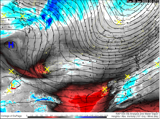
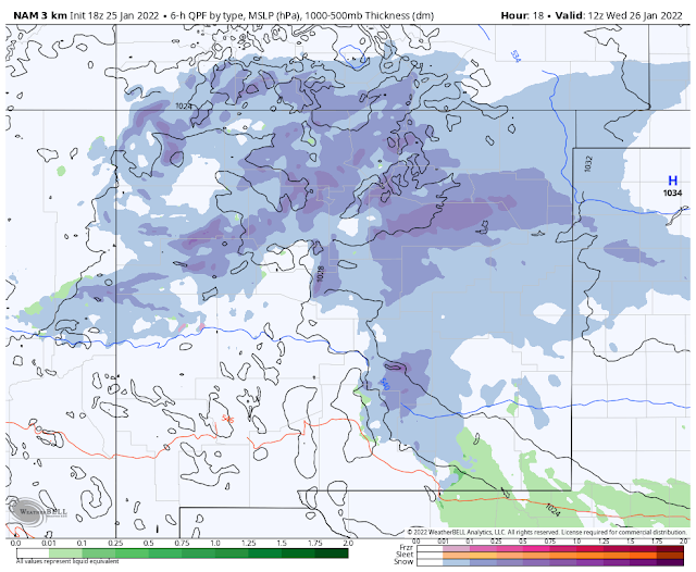
Looking at the 18,000' level (500 Millibars) of the atmosphere this Tuesday afternoon shows that a fairly strong and cold mid-upper level storm was centered over far northwestern Arizona as of 1 PM MST. This next inbound winter storm is forecast to continue moving southeast tonight into Wednesday morning. By around noontime tomorrow it is forecast to be located near Ruidoso. The storm is then forecast to swing east out of the state into the Texas Panhandle by sunset.
Valid Tonight.
Valid Wednesday.
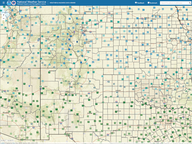
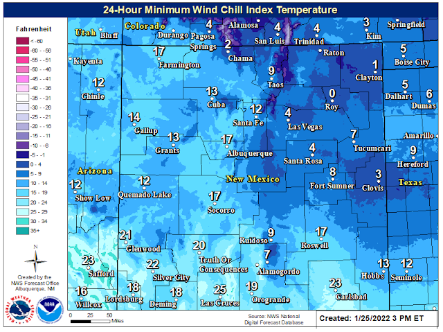
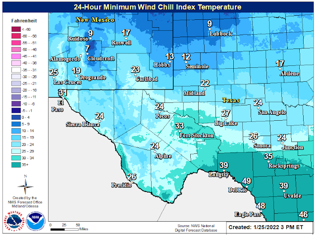
Current Wind Chill Temperatures At 3 PM MST.
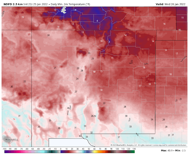
Temperatures Drop Tonight & Won't Recover Wednesday!
Arctic air has entered far northeastern New Mexico as of 3 PM MST this Tuesday afternoon. Temperatures at Raton and Clayton were near freezing with wind chills in the teens. This colder air will spread southward and westward tonight.
Northeasterly to easterly winds will develop overnight into Wednesday. Which combined with temps near to below freezing across the area will produce wind chill readings in the single digits in the mountains and parts of Eastern and Southeastern New Mexico and West Texas. Other locations will see wind chill readings in the teens to near 20ºF.
Our high temperatures here in Southeastern New Mexico for tomorrow (Wednesday) will occur at or around midnight tonight. Our afternoon highs will hover around freezing all day Wednesday with little change in the thermometer expected. This after highs this afternoon in the low 60's.
Our high temperatures here in Southeastern New Mexico for tomorrow (Wednesday) will occur at or around midnight tonight. Our afternoon highs will hover around freezing all day Wednesday with little change in the thermometer expected. This after highs this afternoon in the low 60's.
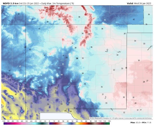
NWS NDFD Forecast High Temperatures Wednesday.
Valid At 5 AM MST Wednesday Morning.
Valid At 11 AM MST Wednesday Morning.
Black Ice On Area Roadways Will Make Travel Dangerous!
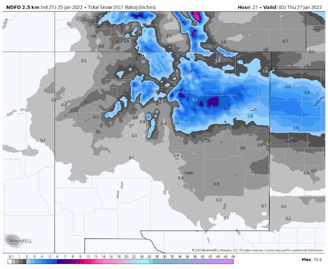
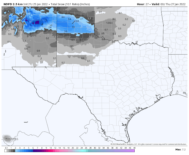
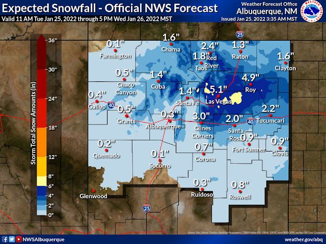
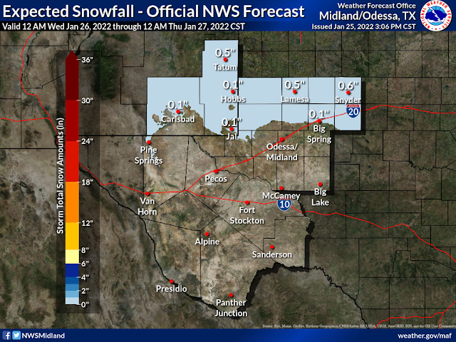
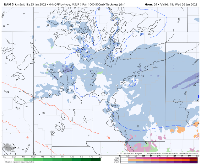
A wintry mix of precipitation is forecast for the mountains and area late tonight into Wednesday afternoon. Light rain and or light drizzle will change over to light freezing rain and light freezing drizzle early Wednesday morning locally. At times we may see a combination of sleet and snow mixing in with the freezing rain and drizzle. Current forecasts are calling for an inch of snow or less across the Southeastern Plains.
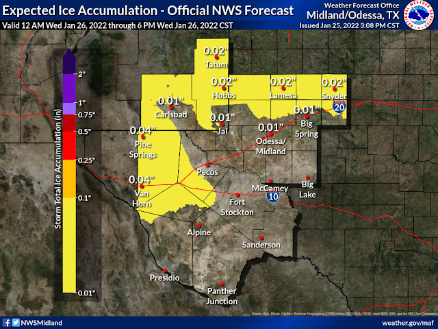
The biggest concern will be the freezing rain and freezing drizzle combined with areas of freezing fog which will lead to black ice formation on area roads. Add the snow on top of the ice and problems on local roadways will develop. Especially on bridges and overpasses. Exposed surfaces will also glaze over with ice accumulations of less than a tenth of an inch forecast currently (as of 3 PM MST Tuesday).
Light freezing drizzle and light freezing rain combined with freezing fog is also forecast for the Sacramento, Capitan, and Guadalupe mountains late tonight into Wednesday. Light snow will also mix in with the freezing precipitation at times making for dangerous driving conditions on local roads. Current forecasts do not call for significant snowfall amounts in the mountains. An inch or so will be possible.
Please Visit The Albuquerque National Weather Service Web Page For The Winter Storm Warning/Winter Weather Advisories For Northeastern And North Central New Mexico.
National Weather Service Midland/Odessa TX 150 PM CST Tue Jan 25 2022 NMZ027>029-033-034-TXZ271>274-278-261100- /O.NEW.KMAF.WW.Y.0002.220126T0800Z-220126T2000Z/ Guadalupe Mountains of Eddy County-Eddy County Plains- Northern Lea County-Central Lea County-Southern Lea County- Guadalupe and Delaware Mountains-Van Horn and Highway 54 Corridor- Eastern Culberson County-Reeves County Plains- Davis Mountains Foothills- Including the cities of Queen, Artesia, Carlsbad, Tatum, Hobbs, Lovington, Eunice, Jal, Pine Springs, Van Horn, Pecos, and Alpine 150 PM CST Tue Jan 25 2022 /1250 PM MST Tue Jan 25 2022/ ...WINTER WEATHER ADVISORY IN EFFECT FROM 2 AM CST /1 AM MST/ TO 2 PM CST /1 PM MST/ WEDNESDAY... * WHAT...Mixed wintry precipitation expected. Total snow accumulations of less than one inch. Ice accumulations up to .06 inch. * WHERE...Portions of Southeast New Mexico, The Guadalupe and Delaware Mountains, Van Horn area, Davis Mountain Foothills around Kent. * WHEN...From 2 AM CST /1 AM MST/ to 2 PM CST /1 PM MST/ Wednesday. * IMPACTS...Plan on slippery road conditions and low visibility. The hazardous conditions could impact the morning commute. * ADDITIONAL DETAILS...Interstate 10 and 20 split, Kent, Van Horn, Guadalupe Pass, Queen, and the Hope areas are of most concern. PRECAUTIONARY/PREPAREDNESS ACTIONS... Slow down and use caution while traveling. In New Mexico, the latest road conditions can be obtained by calling 800-432-4269. In Texas, the latest road conditions can be obtained by calling 800-452-9292. && $$
The Truth Is Stranger Than Fiction!


Comments
Post a Comment
Your comments, questions, and feedback on this post/web page are welcome.