

Turning Much Colder With A Chance For Light Snow Tonight Into Thursday.

Carlsbad, New Mexico.
Looking to the south at very high altocumulus standing lenticular clouds (estimated around 21,000'). While in the distance a grass fire burns just southwest of Black River Village.
Turning Much Colder With A Chance For Light Snow.
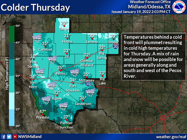
A weak upper-level trough of low pressure is draped overhead late this afternoon. An arctic cold front that moved through the area today will spread a much colder airmass over us into Friday morning. Temperatures to our north across the Eastern Plains of New Mexico have already dropped down into the 30's as of 5 PM MST this Wednesday afternoon.
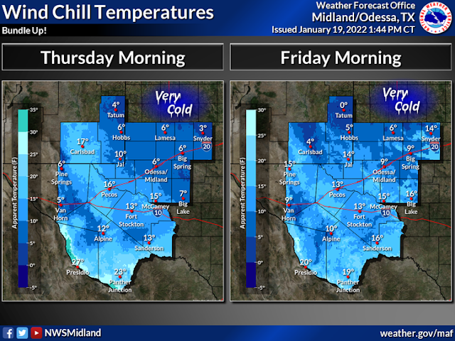
Lows tonight into Thursday morning will drop down into the low to mid-teens to near 20-degrees. Winch chill values Thursday morning are forecast to range from the single digits to teens across the lower elevations of Southeastern New Mexico and parts of West Texas. Highs locally across the Southeastern Plains of New Mexico and parts of West Texas will only be in the 30's on Thursday...many areas not much above freezing.
Low temperatures Friday morning are forecast to be close to Thursday morning's lows...maybe a few degrees warmer. Wind chill readings Friday morning are forecast to range from near 0º to the single digits areawide.


The Cloudcroft area managed to pick up a half of an inch to three-quarters of an inch of snow Tuesday night.
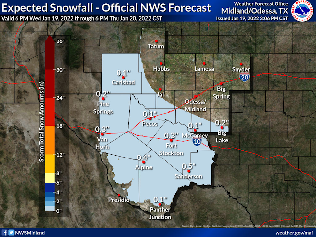
Scattered light rain showers are forecast to overspread the area late tonight then change over to a rain/snow mix before changing over to all snow on Thursday. Current forecasts indicate that for the most part Southeastern New Mexico and much of West Texas will see an inch or less of accumulating snowfall. A couple of inches are possible in the Sacramento mountains.
A second storm will affect the area this weekend with a chance for more snow.
A second storm will affect the area this weekend with a chance for more snow.
Special Weather Statements.
Special Weather Statement
National Weather Service Albuquerque NM
246 PM MST Wed Jan 19 2022

NMZ208-210-212>218-220>241-201800-
Southwest Mountains-Tusas Mountains Including Chama-
Glorieta Mesa Including Glorieta Pass-
Northern Sangre de Cristo Mountains-
Southern Sangre de Cristo Mountains-
East Slopes Sangre de Cristo Mountains-Upper Rio Grande Valley-
Espanola Valley-Santa Fe Metro Area-Lower Rio Grande Valley-
Sandia/Manzano Mountains Including Edgewood-Estancia Valley-
Central Highlands-South Central Highlands-Upper Tularosa Valley-
South Central Mountains-
Johnson and Bartlett Mesas Including Raton Pass-
Far Northeast Highlands-Northeast Highlands-Union County-
Harding County-Eastern San Miguel County-Guadalupe County-
Quay County-Curry County-Roosevelt County-De Baca County-
Chaves County Plains-Eastern Lincoln County-
Southwest Chaves County-San Agustin Plains and Adjacent Lowlands-
246 PM MST Wed Jan 19 2022

...LIGHT SNOWFALL WEDNESDAY EVENING THROUGH THURSDAY MORNING
ACROSS CENTRAL AND EASTERN NEW MEXICO...

A quick-hitting storm system will bring snow to portions of
northern and eastern New Mexico through Thursday morning. The
highest snow totals of 2 to 4 inches are likely across the Sangre
de Cristo Mountains as well as the Sacramento Mountains. A quick
1 to 2 inches is also possible across the northeast plains with a
dusting of snow elsewhere across the east. Slick and icy roadways
may make for difficult travel conditions early Thursday morning,
particularly along mountain passes. Interstate 25 from Las Vegas
to Raton Pass, U.S. Highway 64/84, and U.S. Highway 412 may also
be impacted. Motorists are encouraged to slow down and allow extra
time for the morning commute.

For the latest road conditions visit nmroads.com or dial 5-1-1.

$$

15
Special Weather Statement
National Weather Service Midland/Odessa TX
436 PM CST Wed Jan 19 2022

NMZ027>029-033-034-TXZ045>048-050>053-059>063-067>070-075-082-
270>279-281-282-201115-
Guadalupe Mountains of Eddy County-Eddy County Plains-
Northern Lea County-Central Lea County-Southern Lea County-Gaines-
Dawson-Borden-Scurry-Andrews-Martin-Howard-Mitchell-Loving-
Winkler-Ector-Midland-Glasscock-Ward-Crane-Upton-Reagan-Pecos-
Terrell-Guadalupe Mountains Above 7000 Feet-
Guadalupe and Delaware Mountains-Van Horn and Highway 54 Corridor-
Eastern Culberson County-Reeves County Plains-Chinati Mountains-
Marfa Plateau-Davis Mountains-Davis Mountains Foothills-
Central Brewster County-Presidio Valley-Lower Brewster County-
Including the cities of Queen, Artesia, Carlsbad,
Carlsbad Caverns NP, Tatum, Hobbs, Lovington, Eunice, Jal,
Seminole, Lamesa, Gail, Snyder, Andrews, Stanton, Big Spring,
Colorado City, Mentone, Kermit, Odessa, Midland, Garden City,
Monahans, Crane, McCamey, Rankin, Big Lake, Fort Stockton,
Dryden, Sanderson, Guadalupe Mountains NP, Pine Springs,
Van Horn, Pecos, Marfa, Fort Davis, Alpine, Big Bend NP,
Panther Junction, Marathon, Presidio, Lajitas, and Castolon
436 PM CST Wed Jan 19 2022 /336 PM MST Wed Jan 19 2022/

...WIDESPREAD ARCTIC BLAST WITH SOME SNOWFALL ACROSS PARTS OF THE
TRANS PECOS AND SOUTHEAST NEW MEXICO THURSDAY...

Very cold air that originated in the Canadian Yukon and then
strengthened across the northern high plains will make its
presence widely known overnight. Northeast winds of 15 to 20 mph
will usher in the frigid air and by 6 AM Thursday wind chill
readings will range from the single digits across much of the
Permian Basin and Southeast New Mexico to mid and upper teens
across the Trans Pecos.

There is the possibility of snow, especially across the Trans Pecos,
where one half inch to more localized amounts as high as 2 inches
are possible. Uncertainty exits as to where the most favored
areas for accumulating snow will occur. However the area from the
Davis Mountains to Glass Mountains and from Van Horn to the I-10
and I-20 split are suspected. Farther east across the Permian
Basin and Southeast New Mexico very dry air will undercut any
moisture aloft favoring flurries. The favored window of time of
for snow will be between 5 AM and 6 PM Thursday.

Prepare now for the cold weather, protect pipes, plant, pets, and
check on others.

$$
The Truth Is Stranger Than Fiction!


Comments
Post a Comment
Your comments, questions, and feedback on this post/web page are welcome.