A Gorillia Hail Kind Of Day For SE NM & W TX!
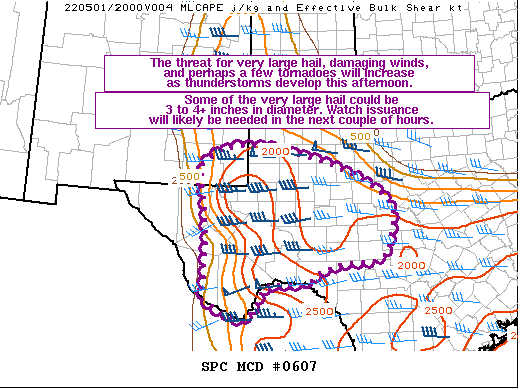
SPC Mesoscale Discussion #607.
Wow! You don't see wording for our neck of the woods like this very often from the SPC. 3" to 4"+ diameter hail. A gorilla hail kind of day for SE NM & W TX.
I'll be out chasing this afternoon. No core punching for me. Thinking the Carlsbad-Hobbs-Jal-Orla areas.
   Mesoscale Discussion 0607
   NWS Storm Prediction Center Norman OK
   0104 PM CDT Sun May 01 2022

   Areas affected...Portions of far southeastern NM into west TX and
   the Edwards Plateau

   Concerning...Severe potential...Watch likely

   Valid 011804Z - 012030Z

   Probability of Watch Issuance...95 percent

   SUMMARY...The threat for very large hail, damaging winds, and
   perhaps a few tornadoes will increase as thunderstorms develop this
   afternoon. Some of the very large hail could be 3 to 4+ inches in
   diameter. Watch issuance will likely be needed in the next couple of
   hours.

   DISCUSSION...Low-level moisture continues to stream northward early
   this afternoon in tandem with a 20-25 kt southeasterly low-level jet
   across parts of west TX and vicinity. Diurnal heating of this moist
   airmass and the presence of rather steep mid-level lapse rates
   indicated on the 12Z MAF sounding are already supporting MLCAPE of
   1500-2000 J/kg as of 18Z. Additional heating and surface dewpoints
   generally increasing into the low to mid 60s will likely foster even
   stronger instability by late afternoon, with MLCAPE of 2500-3500
   J/kg possible. The east-southeasterly low-level upslope flow will
   likely aid convective initiation across the higher terrain of
   southeastern NM and west TX over the next couple of hours. A veering
   and strengthening wind profile with height through mid levels will
   support around 40-50 kt of effective bulk shear, with considerable
   speed shear noted at mid/upper levels in various NAM/RAP forecast
   soundings across this region.

   This favorable thermodynamic and kinematic environment will easily
   support scattered supercells with an attendant threat for very large
   hail. Some of the this hail could be 3 to 4+ inches in diameter
   given the large reservoir of buoyancy that will be available,
   presence of steep mid-level lapse rates, and long/straight
   hodographs in the 3-9 km layer. Although the low-level flow is
   fairly modest at the moment, some strengthening of the southeasterly
   low-level jet is forecast by early evening. As low-level hodographs
   correspondingly increase/lengthen, there should be a risk for a few
   tornadoes, especially along/near the northward-advancing warm front.
   Severe/damaging winds could also become a concern as supercells may
   eventually congeal into small bowing clusters across parts of the
   Edwards Plateau this evening. Observational trends will be closely
   monitored for signs of convective initiation across west TX, and a
   watch will likely be needed in the next couple of hours.

   ..Gleason/Hart.. 05/01/2022

   ...Please see www.spc.noaa.gov for graphic product...

   ATTN...WFO...EWX...SJT...MAF...

   LAT...LON   29410418 30880413 32450434 32830377 32940319 32880226
               32560101 32220017 31889956 31499919 31129917 30429938
               30269972 30230049 30050113 29740151 29790230 29690263
               29230284 28940316 29160377 29410418
There Are None So Blind As Those Who Will "Not" To See.


Comments
Post a Comment
Your comments, questions, and feedback on this post/web page are welcome.