


Dryline Backs West Today Into Wednesday - T-Storm Chances Return.

South Of Artesia, NM.
Altocumulus Mammatus Clouds.
Blog Updated At 1:08 PM MDT Tuesday.


(7:30 AM MDT Tuesday, May 10, 2022).

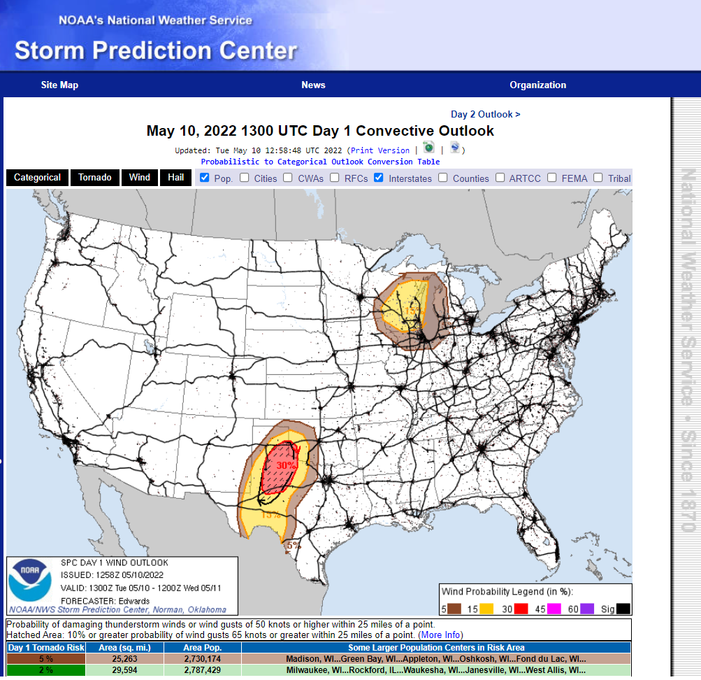
Dryline Thunderstorms Return.
As the dryline backs westward and northward into Southeastern and Eastern New Mexico this morning surface dew point temperatures are beginning to rise. As of 7:30 AM MDT dew point temperatures have already climbed above 50º southeast of a line from Hobbs to near Orla, Texas along the dryline. Dew Point temperatures have climbed up to 72º at the Odessa, Schlemeyer Airport and 70º at the Midland/Odessa International Airport. Meanwhile on the west side or dry side of the dryline dew point temperatures are mostly in the teens and 20's across the rest of Southeastern and Eastern New Mexico.
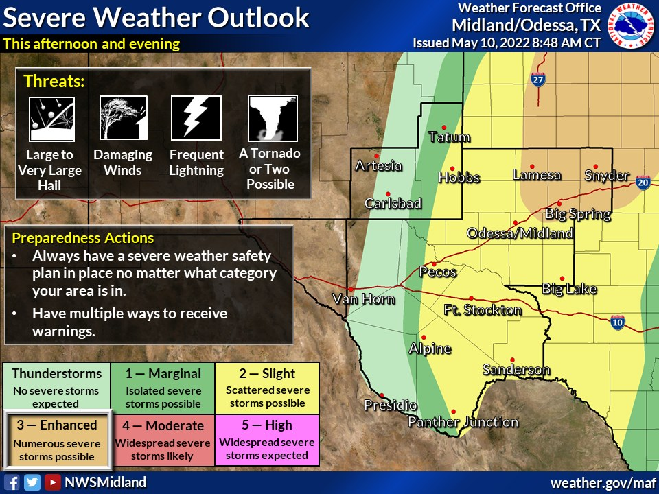
By this afternoon the dryline will have mixed east to near the NM/TX state line. A small area around Hobbs will have the best chances (Slight Risk Area) of seeing a few isolated to scattered thunderstorms this afternoon...some of which may become severe. Lesser chances for thunderstorms will occur the further west you go into the local area.
Some of these thunderstorms will last into the early evening hours and may be severe. The primary severe weather threats this afternoon and evening will be damaging thunderstorm wind gusts in excess of 58 mph. Severe-sized hail is also possible (quarter size or 1" in diameter or larger). As always deadly cloud-to-ground lightning strikes will accompany any thunderstorm.
Localized heavy rainfall from the strongest thunderstorms might possibly create localized flash flooding with the strongest storms but this will be isolated in nature. But overall most of the area will not get rainfall and certainly not enough to put a dent or end the ongoing drought.
Localized heavy rainfall from the strongest thunderstorms might possibly create localized flash flooding with the strongest storms but this will be isolated in nature. But overall most of the area will not get rainfall and certainly not enough to put a dent or end the ongoing drought.
Thunderstorm chances go up slightly Wednesday into Wednesday night as the dryline surges back west to the east slopes of the Guadalupe, Sacramento, and Capitan Mountains tonight.
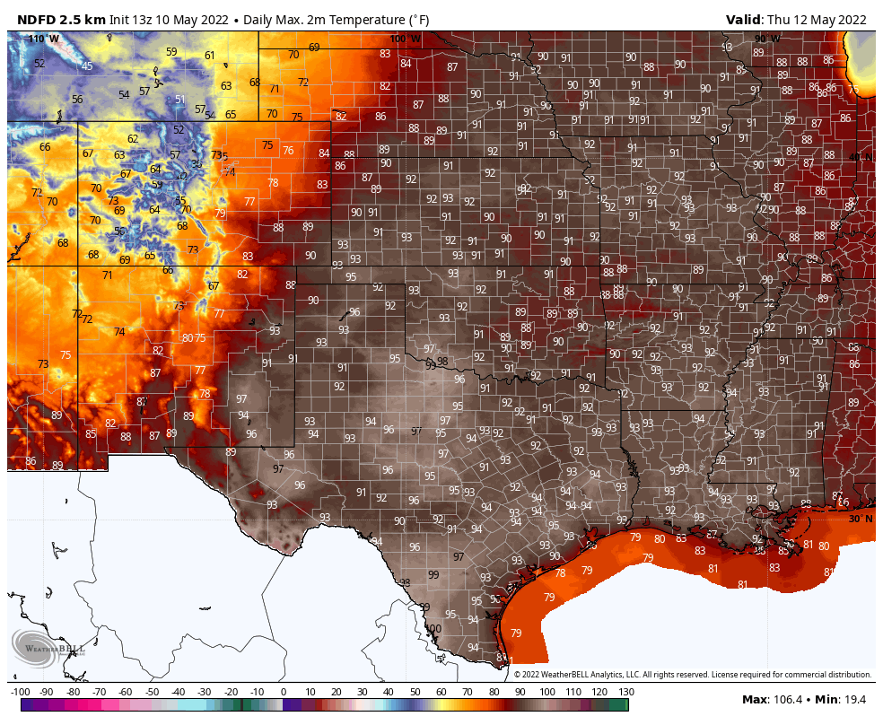
Continued Hot.
Today.

Wednesday.

Thursday.
Friday.

NWS NDFD Total Rainfall Forecast.

There Are None So Blind As Those Who "Will - Not" To See.


Bring on the rain!
ReplyDelete