

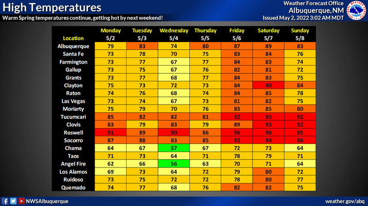
First Triple-Digit Temps This Weekend Ahead Of Our Next Windbag Of A Storm?

Valid At 6 PM MDT Sunday, May 8, 2022.
GFS 500 MB (18,000') Heights/Anomaly Forecast.

Valid At 6 PM MDT Sunday, May 8, 2022.
GFS 500 MB (18,000') Wind/Jet Stream Forecast.

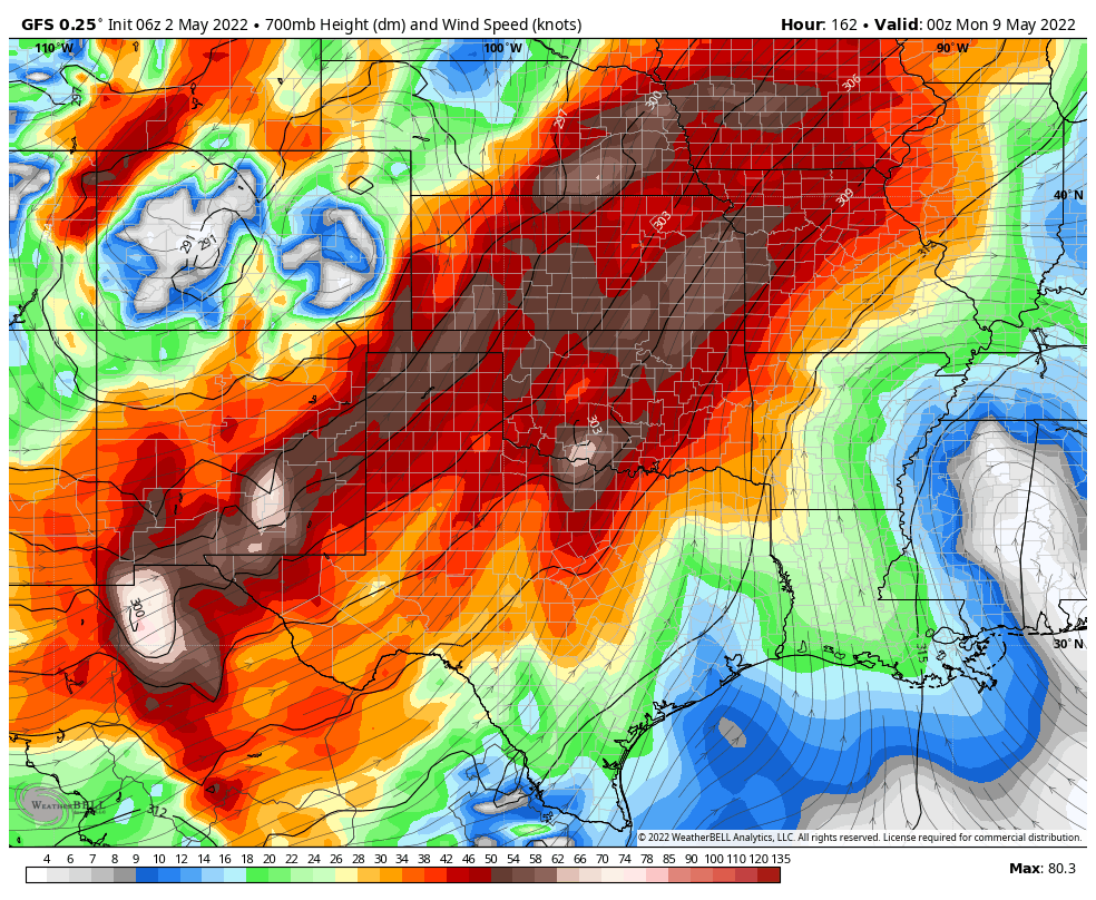
GFS 700 MB (10,000') Wind Forecast.
Valid At 6 PM MDT Sunday, May 8, 2022.

Valid Saturday, May 7, 2022.

ECMWF High-Temperature Anomaly Forecast.

ECMWF &-Day High/Low-Temperature Forecasts.
Roswell.

Artesia.

Carlsbad.

Sierra Blanca Regional Airport.

Uneventful Week Ahead - A Change Next Weekend.
Near normal to slightly above normal temperatures are forecast for the area today into Thursday. A couple of weak cold fronts will enter the area this week with little effect on our temperatures. Our afternoons will be breezy at times with no hope for rain this week.
A strong mid-upper level short wave trough of low pressure is forecast to dive into the Four Corners Region late this upcoming weekend. Details are sketchy this far out but it appears this storm will be another windbag for New Mexico and surrounding areas. More blowing dust is certainly possible. Critically Dangerous Fire Weather Conditions will continue off and on into the foreseeable future. Especially this next weekend.
A strong mid-upper level short wave trough of low pressure is forecast to dive into the Four Corners Region late this upcoming weekend. Details are sketchy this far out but it appears this storm will be another windbag for New Mexico and surrounding areas. More blowing dust is certainly possible. Critically Dangerous Fire Weather Conditions will continue off and on into the foreseeable future. Especially this next weekend.
By Friday our high temperatures here in Southeastern New Mexico are expected to soar up into the mid-upper 90's. We may see our first triple-digit highs of the season Friday and Saturday.
It's possible that another dryline severe weather event will set up this weekend also. I chased a prolific supercell thunderstorm that produced lots of large damaging hail from Lovington, New Mexico to Seagraves and Wellman, Texas yesterday. I'll post a blog with photos and videos of my chase in a day or two.
There Are None So Blind As Those Who "Will - Not" To See.


Comments
Post a Comment
Your comments, questions, and feedback on this post/web page are welcome.