My Blog Archive List (July 2010 - August 2025).

Show more

Cannon AFB (KFDX) Radar Outage

Updated 10/01/2025 11am The Cannon Air Force Base (KFDX) WSR-88D will remain inoperable for an extended period due to a hardware failure at the site. Parts have been ordered. There is currently no estimate on when the radar will return to service. KFDX radar is the only radar coverage for portions of eastern New Mexico. However, you may find KPUX, KAMA, KLBB, and KMAF radars useful. If you have questions or concerns, please contact Cannon AFB Public Affairs at 575-784-4131.

Viewing My Web Page

If you are viewing my web page on your cell phone, then be sure and click on the three white bars located in the top left-hand corner of the page (only visible on your phone). This is the menu bar, and it opens up additional links and graphics. Such as forecast maps, severe weather outlooks, current conditions, radar and satellite links, and more.

Seasons First Triple Digit Temps Saturday.

May 4, 2022.
Hondo, New Mexico.

Blast Furnace Weather Returns.


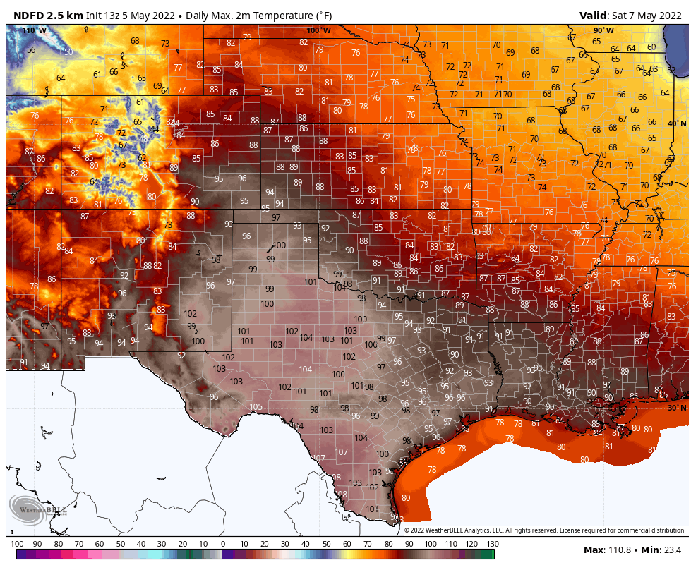
Saturday will be a blast furnace type of weather day for the local area as forecast high temps across the Southeastern Plains and nearby West Texas are expected to range from 100º to 103º. Southwesterly winds will gust up into the 25-35 mph range along with single-digit afternoon relative humidity values.

Southwesterly winds will gust up to around 30-45 mph in the mountains. 

Needless to say that the fire danger will continue to be in the Critically Dangerous to Extreme range off and on into the next week. Summer comes early this year as the drought continues to worsen.

The mountains will be somewhat cooler with highs on Saturday ranging from the low-mid 80's in the Ruidoso area to near 70º in Cloudcroft. Naturally the higher in elevation you go up the cooler the temps.

Yet another widespread dangerous high wind/blowing dust/Critically Dangerous Fire Weather event is shaping up for next Monday statewide. The dryline looks to become active again across parts of the Eastern and Southeastern Plains eastward into West Texas next week. 

There Are None So Blind As Those Who "Will - Not" To See.

Comments

Current US Hazardous Weather Watch/Warning Map

New Mexico

Eddy County

Guadalupe Mtns Eddy & Culberson County

Chaves County Plains & Mtn's

Lea County

Lincoln County

Otero County

Pagosa Springs, Colorado Flooding Oct 12, 2025

Arizona Flooding - Oct 12, 2025

🔴 Live 24/7 National Weather Radar & Alerts, Weather Intensity Score & YallBot!

Ruidoso Live Webcam

Ski Apache Webcam Live Link

Ski Apache Webcam Live Link
Click On The Image To Open It Up

Cloudcroft Live Webcam

Roswell Live EarthCam

New Mexico Weather Tweets

Average Daily High/Low Temperatures & Rainfall/Snowfall

My Rainfall Totals. 2.1 NNW Downtown Carlsbad, NM.

Top 10 Most Popular Posts

Artesia, NM Mothership Supercell Thunderstorm. 9-17-2016.

Monster Of A Snowstorm Coming This Christmas Weekend?

Powerful Winter Storm Is Hammering New Mexico! Worst Is Yet To Come.

25th Anniversary Of The Carlsbad, NM (May 31, 1991) Tornado Coming Up.

Major Winter Storm May Paralyze/Bury Parts Of NM & Nearby Areas Tonight Into Wednesday!

2011 Skywarn Spotter Training Classes & My Thoughts.

Tonight's GFS Is As Drunk As This Mornings ECMWF. Historic Snowstorm Next Weekend?

Are We Fixing To Go From Drought To Flood In SE NM?

Major Winter Storm To Hammer New Mexico & West Texas Thanksgiving Week!

Cloudcroft & Ruidoso, NM Seasonal Snowfall Totals.

My Favorite Blog List.

Substack

Disclaimer

This blog and its contents are for informational purposes only! Always have multiple sources of information available to rely upon during severe weather. Do not rely solely on the Internet. Be weather-aware, plan ahead, have a backup plan, and be ready to act before severe weather strikes your location.