Blast Furnace Weather Today & Friday - Strong Cold Front Arrives Saturday.


Valid AM MDT Through 6 PM MDT Thursday, May 19, 2022.

Smoke from the Black and Bear Trap fires continues to impact our local area and points eastward. That haze you see in the sky is not clouds nor haze but layers of smoke aloft from the above-mentioned fires. As of Wednesday, May 18th the Hermits Peak and Calf Canyon fires have burned 301,971 acres and are 34% contained. The Black Fire has burned 77,529 acres and is 0% contained. The Cerro Pelado Fire has burned 45,605 acres and is 74% contained. And the Bear Trap Fire has burned 17,122 acres and is 28% contained. 


Today.


Friday.


Red Flag Warnings continue in effect for much of New Mexico and nearby areas today and Fire Weather Watches are in effect for Friday. Critically Dangerous Fire Weather Conditions will prevail today into Friday. Strong gusty southwesterly-westerly winds will gust up to around 40-50 mph over much of northern and central New Mexico today and Friday further aggravating the ongoing fire fighting efforts around the state. Southwesterly winds are forecast to gust up to around 25-35 mph across Southeastern New Mexico today and Friday.


Today.


Friday.


Saturday.


NWS NDFD Forecast Low Temperatures Sunday Morning.


NWS NDFD Forecast High Temperatures & Anomalies.

Sunday. 


Blast Furnace Weather Today & Friday - Cold Front Saturday.


Valid At 6 PM MDT Monday, May 23, 2022.


Our recent trend of excessively hot, bone dry, and sometimes windy days will continue today and Friday before a change occurs Saturday. Forecast high temperatures across Southeastern New Mexico today and Friday will range from 100º to 104º. These temps are some 10º to 15º above normal for the date.

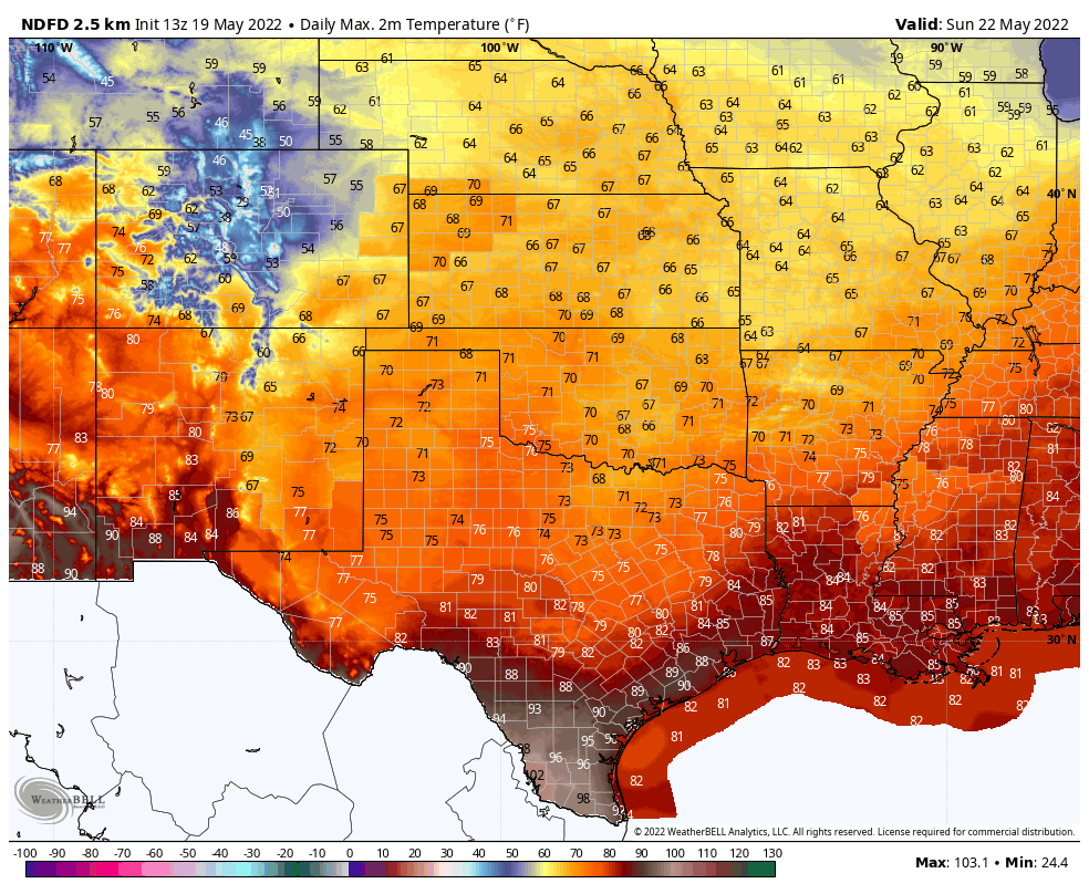
Highs across the Sacramento Mountains today will range from the low 70's in the Cloudcroft area to the mid 80's in the Ruidoso area. Highs on Friday will range from the mid-upper 60's in the Cloudcroft area to near 80 in the Ruidoso area.

A strong cold front (for this time of the year) is forecast to drop south into New Mexico on Saturday ushering in much colder temperatures Saturday into Monday morning. High temperatures across the Southeastern Plains on Sunday are only forecast to be in the low-mid 70's. These temps will be some 10º to 15º below normal. A welcome change for sure. 

Highs across the Sacramento Mountains on Sunday are forecast to be in the 60's. Lows Sunday morning are forecast to drop down to near 40º to near 50º. Lows in the Sacramento Mountains Sunday morning are forecast to range from the mid 30's to near 40º.

WPC Precipitation Forecast.

Valid Today Through Tuesday Morning.

There are indications in the forecast models that we may see some measurable rainfall return to the local area from Sunday night into next Tuesday or so. Low-level moisture is forecast to increase across the area as a couple of upper air disturbances traverse across the region. The dryline may become active again Monday and Tuesday along with the possibility of severe thunderstorms breaking out along and east of it. The best chances for measurable rainfall will generally occur over the eastern one-third of the state.


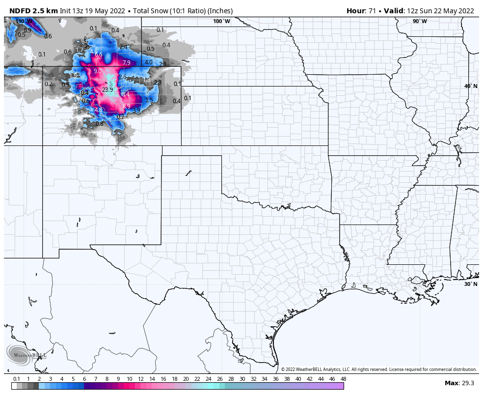
NWS NDFD Storm Total Snowfall Forecast.

Valid At 6 AM MDT Sunday Morning.

A late-season snowstorm is forecast to impact the Denver area and much of Colorado Friday and Saturday. Winter Storm Warnings and Watches are in effect for much of North-Central and Northeastern Colorado. Denver could see up to 9" of snow from this storm. Although somewhat rare for this late in the spring this is not an unprecedented event.


All indications are that La Niña conditions will prevail through our summer into the early winter. Which would also support the idea that our current drought will also continue into the summer. 

EL NIÑO/SOUTHERN OSCILLATION (ENSO)
DIAGNOSTIC DISCUSSION
issued by
CLIMATE PREDICTION CENTER/NCEP/NWS
and the International Research Institute for Climate and Society
12 May 2022
 

ENSO Alert System Status: La Niña Advisory


Synopsis:  Though La Niña is favored to continue, the odds for La Niña decrease into the late Northern Hemisphere summer (58% chance in August-October 2022) before slightly increasing through the Northern Hemisphere fall and early winter 2022 (61% chance).

Below-average sea surface temperatures (SSTs) persisted during April across most of the central and eastern equatorial Pacific Ocean [Fig. 1]. Over the past month, the Niño index values decreased, with the latest weekly values ranging from -1.1°C to -1.5°C [Fig. 2], which are quite negative for this time of year. Subsurface temperatures anomalies (averaged between 180°-100°W and 0-300m depth) remained negative [Fig. 3], reflecting an extensive area of below-average temperatures from the surface to ~100m depth across the central and eastern equatorial Pacific Ocean [Fig. 4]. For the monthly average, low-level easterly and upper-level westerly wind anomalies dominated the equatorial Pacific. Convection remained significantly suppressed around the Date Line and was enhanced over the Philippines [Fig. 5]. Overall, the coupled ocean-atmosphere system reflected the continuation of La Niña.

The most recent IRI/CPC plume average for the Niño-3.4 SST index forecasts borderline La Niña conditions during the Northern Hemisphere summer, with increasing odds for La Niña into the fall [Fig. 6]. Similar to last month, the forecaster consensus predicts Niño-3.4 index values to weaken into the summer, but remaining below the threshold of La Niña (Niño-3.4 values equal to or less than -0.5°C). In the near-term, westerly wind anomalies are predicted for mid-late May which supports the weakening of below-average surface and subsurface oceanic temperatures in the coming months. However, much of the model guidance is also hinting at a re-strengthening of La Niña conditions again in the fall and upcoming winter. In summary, though La Niña is favored to continue, the odds for La Niña decrease into the late Northern Hemisphere summer (58% chance in August-October 2022) before slightly increasing through the Northern Hemisphere fall and early winter 2022 (61% chance; click CPC/IRI consensus forecast for the chances in each 3-month period).

This discussion is a consolidated effort of the National Oceanic and Atmospheric Administration (NOAA), NOAA's National Weather Service, and their funded institutions. Oceanic and atmospheric conditions are updated weekly on the Climate Prediction Center web site (El Niño/La Niña Current Conditions and Expert Discussions). Additional perspectives and analysis are also available in an ENSO blog. A probabilistic strength forecast is available here. The next ENSO Diagnostics Discussion is scheduled for 9 June 2022.

To receive an e-mail notification when the monthly ENSO Diagnostic Discussions are released, please send an e-mail message to: ncep.list.enso-update@noaa.gov.


There Are None So Blind As Those Who "Will - Not" To See.

Comments

Current NWS National Watches/Warnings In Effect

Current NWS National Watches/Warnings In Effect
Click On The Map For The Latest Updates

New Mexico

Chaves County Plains & Mtn's

Eddy County

Culberson County

Lea County

Lincoln County

Otero County

Current Watches In Effect

SPC Mesoscale Discussions

Storm Prediction Center (SPC) Day 1 Outlook

NWS Regional Radar

NWS Regional Radar

NWS Midland Radar

Cannon AFB Radar

NWS Albuquerque Radar

Holloman AFB Radar

NWS El Paso Radar

NWS Lubbock Radar

GOES-East - Sector view: Southern Rockies - GEOColor

Current US Temps

Current US Wind Chill/Heat Index Temperatures

NWS Midland Regional Forecast

NWS Midland Regional Forecast

NWS Midland Regional Forecast

NWS Albuquerque Regional Forecast

NWS Albuquerque Regional Forecast

NWS Albuquerque Regional Forecast

NWS Albuquerque Regional Forecast

NWS Albuquerque Regional Forecast

NWS Albuquerque Regional Forecast

NWS Albuquerque Regional Forecast

NWS Albuquerque Regional Forecast

NWS El Paso Regional Forecast

NWS El Paso Regional Forecast

NWS Lubbock Regional Forecast.

NWS Lubbock Regional Forecasts

NWS Lubbock Regional Forecast

NWS Lubbock Regional Forecast

NWS Forecast High Temps Today

NWS Forecast Low Temps Tonight

24-Hour Minimum Wind Chill Forecast

NWS Albuquerque Storm Total Snowfall Forecast

NWS Albuquerque Storm Total Rainfall Forecast

NWS Midland Storm Total Rainfall Forecast

NWS El Paso Storm Total Rainfall Forecast

Average Daily High/Low Temperatures & Rainfall

Average Daily High/Low Temperatures & Rainfall