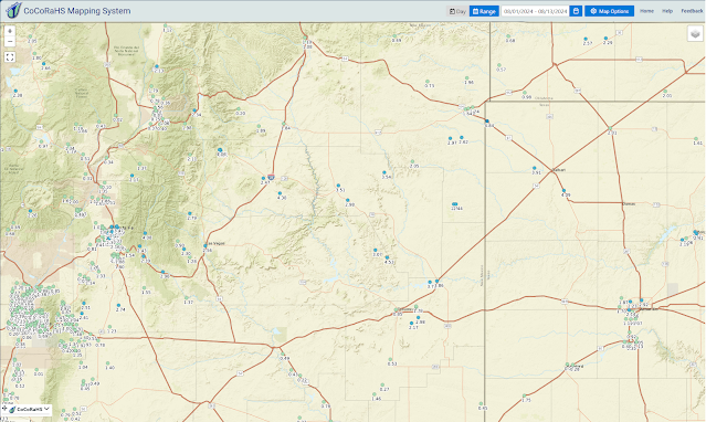
How Hot Has This Summer Been - T-Storms For Many But Not All Of NM.
(August-September-October).
Scattered T-Storms Over Most Of New Mexico.
As the mid-upper level monsoonal high moves off to the east of New Mexico, and re-centers itself over eastern Texas today and tomorrow, a mid-upper level trough of low pressure will swing eastward across the state. This will help increase the chances for scattered t-storms over much of New Mexico over the next couple of days. Most favored areas will continue to be over and near the mountains.
A Flood Watch remains in effect today for parts of the northern mountains and the Sacramento mountains. Scattered to numerous t-storms are forecast to produce heavy to very heavy rainfall today into this evening. As has been the case all summer the burn scar areas will be suspectable to flash flooding even from moderate rainfall amounts.
A few isolated t-storms may drift off of the Sacramento, Capitan, and Guadalupe mountains this afternoon and evening and out onto the southeastern plains.
Other than that our daily high temps across the southeastern plains will continue to range from 100F to 105F for the rest of the week and into the first of next week. Although it has been a hot and dry summer for us it has not been the hottest or driest on record. In 1934 the Carlsbad National Weather Service Climate Co-Op Station recorded 80 days where their daily high temps reached 100F or above. Artesia and Artesia 73 days. So far this year the Carlsbad Airport has recorded 40 days at or above 100F and Artesia 30 days. And the Roswell Airport 41 days.
Nothing has changed as far as the long-range outlooks from now through October are concerned. Above normal temps and drier than normal looks to be the norm. But then again it only takes the remnant tropical moisture from one Hurricane to move up into the area from the Baja Region or from the Gulf of Mexico to change existing conditions. We can, and have, gone from drought to flood in just a matter of a few days. The burning question remains will this be the case this year? Not anytime soon it appears...for now anyway.
(February 15th - August 12th, 2024).
Roswell Weather Service Office.
(1893 - 1972).
(1972 - 2024).
Artesia NWS Climate Co-Op Station.
(1905 - 2024).
Carlsbad NWS Climate Co-Op Station.
(1900 - 2021).
(1930 - 2024).
(1913 - 2022).
(1941 - 2024).
(1919 - 2023).
Year-To-Date.
(January 1st - August 13th, 2024).
(August 1st - August 13th, 2024).
August To-Date.
(August 1st - August 13th, 2024).
There Are None So Blind As Those Who "Will - Not" To See...107.


Comments
Post a Comment
Your comments, questions, and feedback on this post/web page are welcome.