Looking Forward To Big Changes In Our Weather Next Week.
Atoka - South Of Artesia, NM.
ECMWF 500 MB (18,000' MSL) Forecast.
Valid At 6 AM MDT Monday.
GFS 10-Day Rainfall Total Forecast.
Carlsbad.
Models Getting Excited About The End Of Next Week.
First of all note the reported low temperatures across the Rockies and Great Basin areas this morning. Lots of 30's and 40's. A change has started...fall is knocking on the door for some.
Not only are the computer forecast models starting to get excited so to speak about big changes in our weather coming next week, especially next weekend and beyond, so am I. This mornings runs of the GFS, ECMWF, and GEM models all are pointing to a much cooler and wetter period for New Mexico the end of next week and beyond.
Normally I don't get too excited about forecasts that are 7 to 10 days out but after enduring a very hot and dry summer it doesn't take much to excite me weatherwise. The Euro is the most optimistic as far as cooling is concerned. The GFS has a similar forecast as the Euro as far as rainfall is concerned, but has a more widespread pattern from the mountains eastward into Texas.
Anyway I am fully aware that these model forecasts are a stretch this far out in time, and their forecasts will change as we head into next week. So take these forecasts with a grain of salt and be ready for changes. Overall the big picture still calls for a turn to cooler temps, and some much needed rainfall for many areas of the state, including southeastern New Mexico.
A cold front is still forecast to drop down the eastern plains around next Thursday and Friday which will aid in the cool down and increase in low-level moisture. Thunderstorms will increase in coverage as we head towards the end of the week. Given the time of the year and the upper air pattern later next week, I think we will see a couple of days with severe weather also.
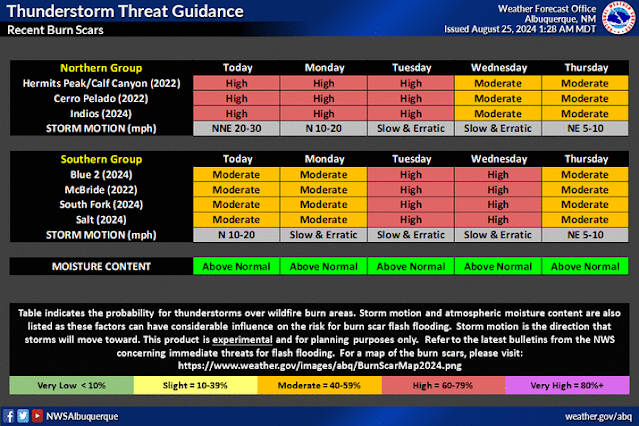
Thunderstorms dropping heavy rainfall will be the cause for flash flooding concerns too. Not just in the mountains either. Especially from slow and erratic moving thunderstorms, and training thunderstorms...one right after another over the same location.
As has been the case this year the burn scar areas will be of particular concern for sudden, and devastating, or even catastrophic flash flooding. I'm sure that the folks in the Ruidoso area don't want to hear this after what they have suffered with this summer from the devastating flash flooding in their area.
Flood Watches are in effect for Monday for parts of the Sangre de Cristo Mountains and Lincoln County. We will see more of this activity next week.
Current model forecasts have many areas potentially picking up 1" to 3" storm totals late next week into with isolated 3" to 6" totals possible. If and that's a really big if the current models continue this trend in their forecasts.
Don't focus of the details of these forecasts yet but just know that we are going to see some much needed relief late next week into the Labor Day weekend. How cool and how wet are yet to be accurately determined.
There Are None So Blind As Those Who "Will - Not" To See...107.


Comments
Post a Comment
Your comments, questions, and feedback on this post/web page are welcome.