A Pattern Change Will End The Relentless Heat & Increase Our Chances For T-storms.
16-Springs Canyon.
East Of Cloudcroft, NM.
Sunday.
Saturday.
Sunday.
Carlsbad.
Roswell.
Sierra Blanca Regional Airport.
Weather Prediction Center (WPC) 7-Day Rainfall Total Forecast.
NWS Albuquerque Burn Scar Flash Flood Matrix Forecast.
NWS Albuquerque Rainfall Chance Forecast.
Finally A Break & End To Our Horrid Summer.
Come next Sunday, September 1st, our meteorological summer will have finally come to a close. And not soon enough for many of us.
Meteorological Fall: September 1st through November 30th.
Meteorological Winter: December 1st through February 28th/29th.
Meteorological Spring: March 1st through May 31st.
Meteorological Summer: June 1st through August 31st.
The models aren't exactly in total agreement concerning the details, but overall they agree that a pattern change is underway. This change in the mid-upper level pattern over the U.S. will mean an end to our horrid summer from hell. So far here at our home in Carlsbad, NM, I've recorded 52 days in which I reached a high temp of 100F or higher. Not a record by any means but enough already.
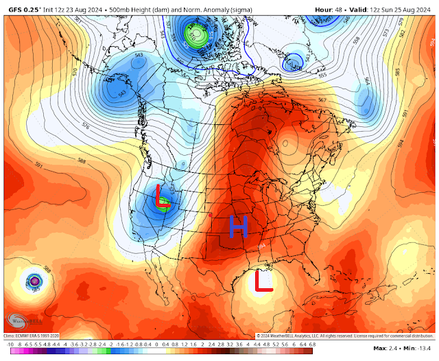
The relentless and persistent monsoonal dome of high pressure that has camped out in our neck of the woods this summer will finally scoot off to the northeast away from us. This will allow an easterly wave to slide to the east along the Gulf Coast today through Monday. After entering south Texas on Monday it is then forecast to head off to the northwest towards West Texas by next Tuesday.
A closed mid-upper level low centered over the California and Oregon border this morning will meander around that area and the Pacific Northwest into early next week. This will allow a mid-level trough of low pressure to dig southward into the Four Corners Region. A secondary closed mid-upper level low/trough of low pressure may force a cold front southward into the state and area late next week. If this happens it would possibly increase our chances for more t-storms and rainfall.
All of this simply means that we are entering our fall upper air pattern as summer fades and our daylight becomes less every day. The Polar and Subtropical jets will become more active as we head into September. As will the Atlantic Basin hurricane season. What that means for New Mexico's weather remains highly uncertain.
After a reprieve from t-storms and flash floods in the Ruidoso area scattered t-storms have once again blossomed up over the Sac's this afternoon. This activity will continue through the weekend and ramp up the first to middle of next week. Some of these t-storms will drop heavy rainfall which will aggravate the flash flood threat over the burn scar areas.
As monsoonal moisture increases over the state this weekend into next week the threat for t-storms to produce heavy rainfall and localized flash flooding will also increase especially next week. The burn scar areas will continue to be a concern for rapid flash flooding.
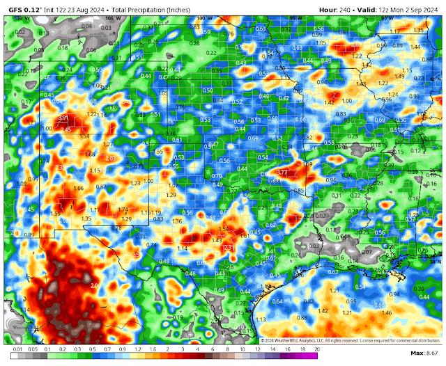
If you draw a line on a map from roughly El Paso to Roswell to Clayton then everything to the left of this line or west of it will have the best chances for t-storms and rainfall. Everyone to the right of that line or east of it will have the least chances over the next week.
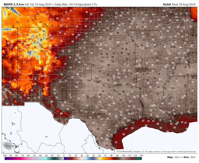
As far as southeastern New Mexico is concerned...well there is good news and not-so-good news. The good news is that our daily high temps will finally start dropping below 100F come Sunday into next week. We will see our daily highs much closer to seasonal averages with readings in the 90's next week instead of 100+.
Now the not-so-good news. It's going to take a bit longer for our chances for significant and meaningful rainfall to occur. That may still be about a week away. If not more depending upon what model forecast you believe. Between now and the end of next week we will start to see a few hit-and-miss widely scattered t-storms. Heavy on the mostly miss type. It's not a lot to look forward to just yet but it's a start hopefully to wetter days ahead. September is typically our wettest month of the year. Our best chances for rain will occur next week.
Our nights will slowly start cooling off as well. It's been rather ridiculous to have morning after morning with low temps in the mid-70s to near 80. Anyway, changes are occurring so here's looking forward to cooler and wetter times ahead. Football season and fall are knocking on our front door.
There Are None So Blind As Those Who "Will - Not" To See...107.


Great info! Thank you
ReplyDelete