Posts

Showing posts from June, 2016

Why Are My Weather Posts Missing From Facebook.

Hello everyone. I just wanted to let you know that my Facebook page was shut down without any warning by Facebook this past Saturday, June 8th. All I was told was that I had violated their community standards. I don't know what triggered that; they didn't tell me. I was told this may be permanent or for six months.
My guess is that it may be because I posted several comments and articles from my Substack page about the riots in LA, and that must have triggered/angered someone, and they complained, thus Facebook shut me down. I don't know this as fact, though. I have appealed this decision, and I'm still waiting for their reply. I have read on X that this has happened to other Facebook users posting about the LA riots as well.
I always share my weather blog posts (that I post here) on my Facebook page and my X page. This included over twelve different New Mexico and West Texas Facebook Community sites. So there are thousands of you out there (based on my views and shares of those posts) who will no longer see those posts. My Facebook page may or may not be restored.
This is another good reason (as the National Weather Service often reminds us) to have multiple ways of receiving severe weather alerts when severe weather threatens your location. My weather web page is one of those ways, and I really appreciate all of you who have and still do use it. Thank you so much!!!
If my Facebook page is restored, I will continue to share my weather blog posts and some of the NWS Watches and Warnings...as I have been doing for years now.

Carlsbad, New Mexico Lightning Show 6-25-2016.

Image
A thunderstorm was rolling into Carlsbad, New Mexico from the southwest and I was 10 miles south of Artesia or 30 miles to the north of Carlsbad looking to the south when I took these. Lesson learned tonight was that the vehicle lights coming towards the camera were really playing havoc with the exposure settings. Not my best lightning shots but my wife and I had fun anyway...in spite of the swarms of mosquitoes that were attacking us. The Truth Is Stranger Than Fiction!

T-Storms Dotted The NM Landscape Yesterday & Overnight.

Image
Radar Estimated & 24-Hour Reported Rainfall Totals. Depicted above is the reported 24-hour rainfall totals as of 7 AM MDT this morning and the radar estimated rainfall totals. Notice how spotty in nature the heavier rainfall totals are...very typical for summertime thunderstorms in New Mexico.  24-Hour Lightning Strike Density Map. 24-Hour Rainfall Totals. (As Of 6 AM MDT This Morning).  June Rainfall Totals. (As Of 6 AM MDT This Morning). Thunderstorms dotted the some of the landscape of New Mexico yesterday into the overnight hours. We had thunder here in Carlsbad off and on from around 11:30 PM until 4:30 AM this morning. I measured .16" in my rain gauge which brings my June total to .26", and my year-to-date total to 2.15". We certainly could use much more of the wet stuff. Sun Is Blank Again - Missing Its Sunspots. This now makes 5 days this year that the sun has gone blank.  Spotless...

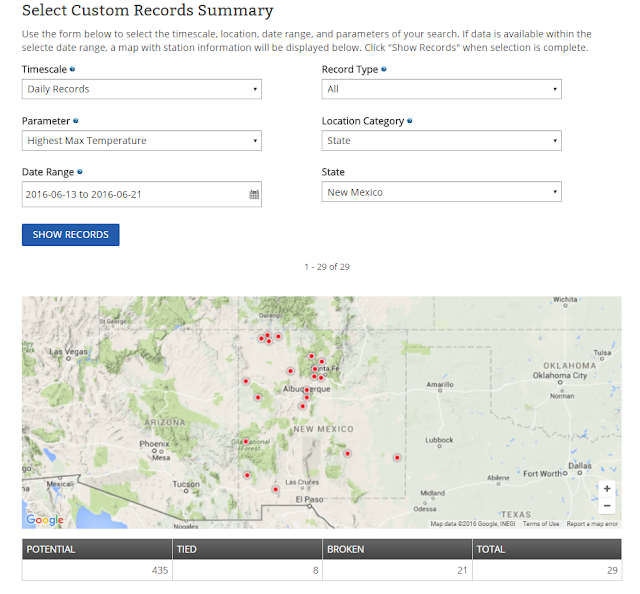
Recent "New Daily Record High Temps" In NM.

Image
New Daily Record High Temps In NM. (June 13-21, 2016).   The Truth Is Stranger Than Fiction!

Saturday, June 18, 2016 Hottest Day Of Year So Far For SE & S NM.

Image
Blog Updated @ 1:20 PM MDT. RTMA Temps @ 5 PM MDT Saturday. Reported High Temps Saturday. (NWS MesoWest). Local Airport Reported High Temps Saturday. My High/Low Temps So Far This Month. (2.1 NNW Downtown Carlsbad, NM). Yesterday (Saturday, June 18, 2016) was one of the hottest if not the hottest day of the year for many of us in southern and southeastern New Mexico. The Carlsbad Climate Co-Op Station registered a high temp of 108ºF making this their hottest reading of the summer so far.  The El Paso Airport came in with 108ºF yesterday for their highest temp so far. The Pecos, TX Airport reported 108ºF yesterday tying  their highest reading with Friday. The Roswell Airport ended up with a high temp of 106ºF but their highest temp so far this month occurred this past Wednesday with 107ºF . The Artesia Airport reported 104ºF yesterday and this ties the 104ºF reported on this p...

Heat Wave Advisory Continues Today In NM - A Look At High Temps So Far.

Image
Smoke From The Dog Head Forest Fire Thursday.    As of 11 PM MDT last night the Dog Head Forest Fire (burning in the Manzano Mountains) southeast of Albuquerque had consumed some 17,000 acres and was 0% contained. 24 homes and 21 other buildings had also been lost to the fire. Notice in the visible satellite images above that smoke from the fire was carried eastward into Eastern New Mexico and West Texas, and then northward into Colorado and Western Kansas on Thursday. Check out this Facebook video posted by Gary Gurule of a close slurry drop on the fire! Heat Wave Continues. RAP 500 MB Analysis @ 13Z/7 AM MDT This Morning.   Our current heat wave is forecast to continue today across much of Eastern, Southeastern, and Southern New Mexico as well as across parts of West Texas. In fact a Heat Wave Advisory remains in effect for the area. Today potentially could be the hottest day of this heat wave. We get somewhat of a break fo...

NWS Albuquerque Burn Scar Matrix

Current National Weather Service Watches/Warnings In Effect.

New Mexico

Chaves County Plains & Mtn's

Eddy County

Culberson County

Lea County

Lincoln County

Otero County

Current US Temps

Current US Wind Chill/Heat Index Temperatures

WPC 7-Day Precipitation Forecast

Roswell Live EarthCam

Ruidoso Live Webcam

Cloudcroft Live Webcam

NWS Midland 3-Day Precipitation Forecast

NWS Midland 3-Precipitation Chances

New Mexico 3-Day Precipitation Forecast

New Mexico Precipitation Chances

NWS El Paso 3-Day Precipitation Forecast

NWS El Paso Precipitation Chances

US 24-Hour Precipitation Forecast

US 3-Day Precipitation Forecast