Temperature RollerCoaster Ride Continues.
South Of Cloudcroft Oct 7th, 2017.
Much colder air lies behind a cold front draped across the Rockies this morning. This front is forecast to slide south into Southeastern New Mexico and West Texas late tonight into early Sunday morning. An upper level trough of low pressure swinging eastward through the northern Rockies will kick the cold front south tonight.
Valid At 6 AM MDT This Saturday Morning.
Valid At Midnight MDT Tonight.
NWS NDFD High Temperature Anomaly Forecast For Today.
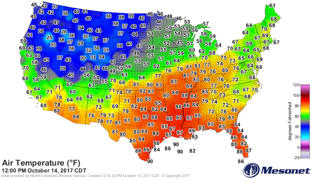
Forecast high temps today across the local area are expected to be in the mid 80's to the low 90's. These temps will be some 5 to 15-degrees above normal for the date.
NWS NDFD Normal High Temps For October 14th.
Normal highs for Southeastern New Mexico for the date are in the upper 70's to near 80.
NWS NDFD Forecast High Temps For Sunday.
Highs on Sunday behind the cold front will be some 20 to 25-degrees colder than today's readings and will be in the mid to upper 60's.
NWS NDFD Forecast High Temperature Anomalies Sunday.
Sunday's highs in the mid to upper 60's will be some 10 to 15-degrees below normal for the date.
NWS NDFD Forecast Low Temps Monday Morning.
Forecast low temperatures come Monday morning are in the upper 30's to low 40's.
Average Temperature For October 2017.
(Oct 1st - Oct 13th).
Locally we are running a couple of degrees above normal for the average temperature for the first 13 days of the month. While much of the West and Northwest has been below normal.
Average Temperature For The Year-To-Date.
(Jan 1st - Oct 13th).
Interesting Forecast From The European Model.
Valid At 6 PM Sunday, Oct 22, 2017.
ECMWF 850 MB (5,000') Temperature Forecast.
(In Degrees Centigrade).
(In Degrees Centigrade).
Valid At 6 PM MDT Saturday, Oct 21, 2017.
Last nights run of the European forecast model (ECMWF) had an interesting forecast for us by the end of next weekend. Its places a deep and cold closed mid and upper level low over south-central New Mexico by Sunday the 22nd. This particular model forecast also has an inch of snow in Clines Corners and Ruidoso and 21 inches in Angel Fire. Not to mention much colder air overspreading the state behind a strong cold front.
Oh well such goes the forecast eight days out. Remember we can hardly count of this as being reliable this far out in time and this mornings run of the GFS does not pick up on this. Should it be true though this would be climatology correct for snow in the Sacramento Mountains of south-central New Mexico for this time of the fall. Not so much for Angel Fire though. 21 inches of fresh snow is pretty excessive.
Remember too that on average most of the local area sees its first frost by around the last two weeks of October. So its time to cool down and I'm ready for it.
(October 14th).
The Truth Is Stranger Than Fiction!


Comments
Post a Comment
Your comments, questions, and feedback on this post/web page are welcome.