Posts

Showing posts from April, 2019

Why Are My Weather Posts Missing From Facebook.

Hello everyone. I just wanted to let you know that my Facebook page was shut down without any warning by Facebook this past Saturday, June 8th. All I was told was that I had violated their community standards. I don't know what triggered that; they didn't tell me. I was told this may be permanent or for six months.
My guess is that it may be because I posted several comments and articles from my Substack page about the riots in LA, and that must have triggered/angered someone, and they complained, thus Facebook shut me down. I don't know this as fact, though. I have appealed this decision, and I'm still waiting for their reply. I have read on X that this has happened to other Facebook users posting about the LA riots as well.
I always share my weather blog posts (that I post here) on my Facebook page and my X page. This included over twelve different New Mexico and West Texas Facebook Community sites. So there are thousands of you out there (based on my views and shares of those posts) who will no longer see those posts. My Facebook page may or may not be restored.
This is another good reason (as the National Weather Service often reminds us) to have multiple ways of receiving severe weather alerts when severe weather threatens your location. My weather web page is one of those ways, and I really appreciate all of you who have and still do use it. Thank you so much!!!
If my Facebook page is restored, I will continue to share my weather blog posts and some of the NWS Watches and Warnings...as I have been doing for years now.

48-Hour Rainfall Totals - As Of April 24th, 2019.

Image
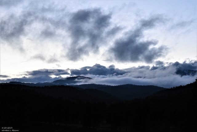
April 13th, 2019. Sunset At Inn Of The Mountain Gods Southwest Of Ruidoso, NM.  NWS 48-Hour Rainfall Totals. (As Of 6 AM MDT Wednesday, April 24th, 2019). NM & W TX 48-Hour Rainfall Totals. (As Of 6 AM MDT Wednesday, April 24th, 2019). SE New Mexico CoCoRaHS Precipitation Summary. (As Of 8 AM MDT Wednesday, April 24th, 2019). NWS Albuquerque 48-Hour Precipitation/Storm Summary. PUBLIC INFORMATION STATEMENT NATIONAL WEATHER SERVICE ALBUQUERQUE NM 935 AM MDT WED APR 24 2019 PRELIMINARY SNOW REPORTS ACROSS NORTH AND CENTRAL NEW MEXICO FOR THE LAST 48 HOURS. ...COUNTY... STORM TOTAL TIME/DATE OF LOCATION /INCHES/ MEASUREMENT ...COLFAX COUNTY... RED RIVER 11 ENE 11.0 700 AM 4/23 - SHUREE SNOTEL. RED RIVER 5 ESE 9.0 300 AM 4/23 - RED RIVER PASS SNOTEL. BLACK LAKE 5 ESE 5.0 915 ...

Thunderstorms & Cooler Temps Mon Night - Wednesday!

Image
April 13th, 2019. Looking west across the take at the Inn of The Mountain Gods southwest of Ruidoso as light snow was falling. There was 1/2" on the ground that Saturday morning. Surface Map Forecast. Valid At 6 PM MDT Monday, April 15th, 2019. GFS 500 Millibar (18,000' MSL) Forecast. Valid At 6 PM MDT Monday, April 15th, 2019. Valid At 6 AM MDT Wednesday, April 17th, 2019. Storm Prediction Center Severe Weather Outlook. (Day 2 Severe Weather Outlook Issued At 11:37 PM MDT Easter Sunday). Severe Weather Outlook For Monday, April 15th, 2019. A couple of features are forecast to come together the first half of this upcoming work week to give the area a decent shot of wetting rains, mountain snows across northern New Mexico, and cooler temperatures.  An upper level trough of low pressure will continue dropping southeastward from southern Nevada this Easter Sunday morning into far southwestern Arizona or northwestern Mexico by...

Ruidoso Flash Flooding From Dolly's Remnants July 26th - 28th, 2008.

Image
5:45 AM MDT July 27th, 2008. Infrared Satellite Image Of Remnant Moisture From Former Hurricane Dolly. Remnants Of Hurricane Dolly July 27, 2008. At the end of July, 2008 Hurricane Dolly moved inland near Brownsville, Texas as a Category 1 Hurricane. Her remnant moisture then moved northwestward up the Rio Grande Valley and into southern New Mexico. During the night of Saturday July 26th into the following day, excessive rainfall fell over the Sacramento Mountains, and the Sierra Blanca Wilderness drainage area west of Ruidoso, New Mexico. Excerpts From My Blog July 27, 2008- "As a result, some of the worst flooding in 100 years occured in Ruidoso, New Mexico late Saturday night into Sunday. The Rio Ruidoso River rose to over 11 feet in Ruidoso, and the Mescalero Lake at the Inn of the Mountain Of Gods rose to within a foot of the spillway. Bonito Lake was overflowing it's spillway. Many roads in the Ruidoso area were closed includ...

Storm Summary April 18th, 2019.

Image
Blog Updated At 3:08 PM MDT Thursday, April 18th, 2019. April 12th, 2019. Snow showers partially obscuring the Capitan Mountains. NWS 2-Day Precipitation Summary. (As Of 6 AM MDT Thursday, April 18th, 2019). New Mexico Reported 2-Day Precipitation Totals. (As Of 9 AM MDT Thursday, April 18th, 2019). Note: These 2-day totals do not include the New Mexico CoCoRaHS totals. These totals include a combination of professional and amateur automated weather station liquid precipitation reports.   SE New Mexico CoCoRaHS 2-Day Precipitation Totals. (As Of 9 AM MDT Thursday, April 18th, 2019). Note: The CoCoRaHS 2-day precipitation totals listed above are collected from a core group of volunteer rainfall and snowfall observers (ordinary citizen public reports) and do not include the precipitation totals reported from automated weather stations.  Cloudcroft At 10:02 AM MDT This Morning. Ski Apache...

NWS Albuquerque Burn Scar Matrix

Current National Weather Service Watches/Warnings In Effect.

New Mexico

Chaves County Plains & Mtn's

Eddy County

Culberson County

Lea County

Lincoln County

Otero County

Current US Temps

Current US Wind Chill/Heat Index Temperatures

WPC 7-Day Precipitation Forecast

Roswell Live EarthCam

Ruidoso Live Webcam

Cloudcroft Live Webcam

NWS Midland 3-Day Precipitation Forecast

NWS Midland 3-Precipitation Chances

New Mexico 3-Day Precipitation Forecast

New Mexico Precipitation Chances

NWS El Paso 3-Day Precipitation Forecast

NWS El Paso Precipitation Chances

US 24-Hour Precipitation Forecast

US 3-Day Precipitation Forecast