


Major Winter Storm For New Year's Eve & New Year's Day?
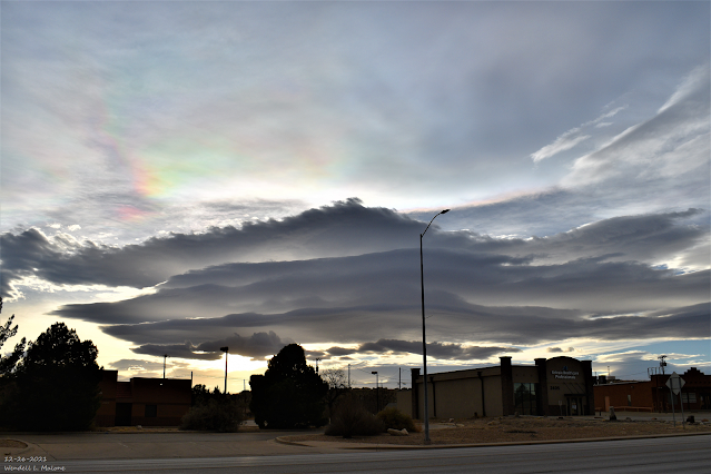
December 26, 2021.
Carlsbad, New Mexico.
Stacked Altocumulus Standing Lenticular Clouds.
My Time Lapse Video Of Altocumulus Standing Lenticular Clouds.
Over Carlsbad, NM Sunday, December 26, 2021).
A Winter Storm To Usher In New Year's?
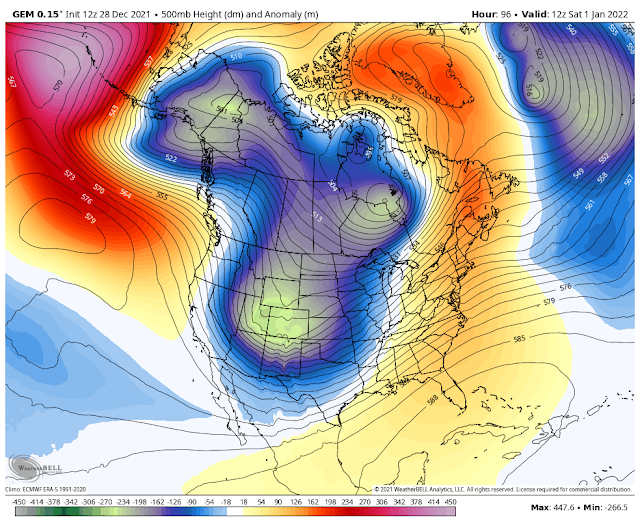
Valid At 5 AM MST New Year's Morning.
All of the forecast models are in pretty good agreement this Tuesday morning concerning the strength, location, and movement of a long-wave 500 millibar long-wave trough of low pressure that will swing across the state and region New Year's Eve into New Year's evening. It is still early so there may be some changes in the trajectory, and strength of this storm in the forecast models before it arrives.
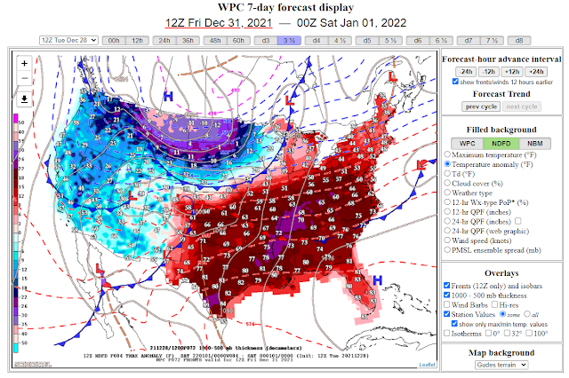

A colder airmass will move into the state and region behind a frontal passage on New Year's Day. After seeing weeks of highs locally in the 70's to near 80 in the lower elevations of Southeastern New Mexico and West Texas this will be a welcome relief to those who love winter. Especially after the string of record high temperatures that were established earlier this month and over the Christmas holidays. Locally our highs will average in the 60's today into Friday before dropping down into the 50's on New Year's Day and the 40's and 50's next Sunday at the lower elevations.
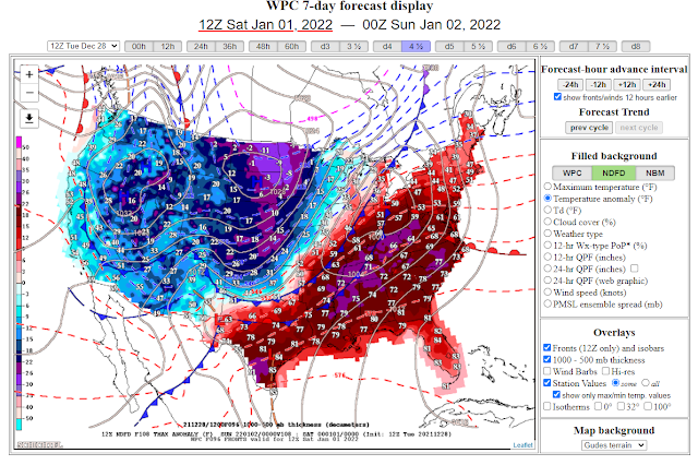
How Cold For The New Year's Weekend?
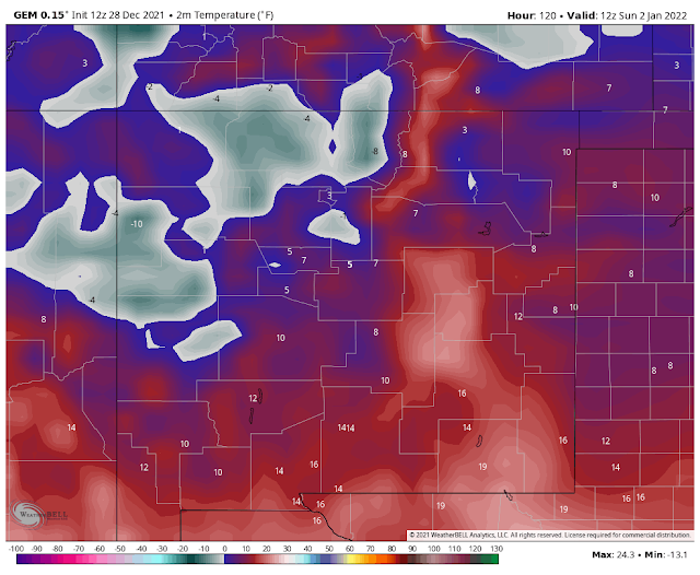
Some of the coldest low temperatures we've seen this season locally may occur Sunday morning.
Canadian (GEM) Forecast High Temperatures Sunday Afternoon.
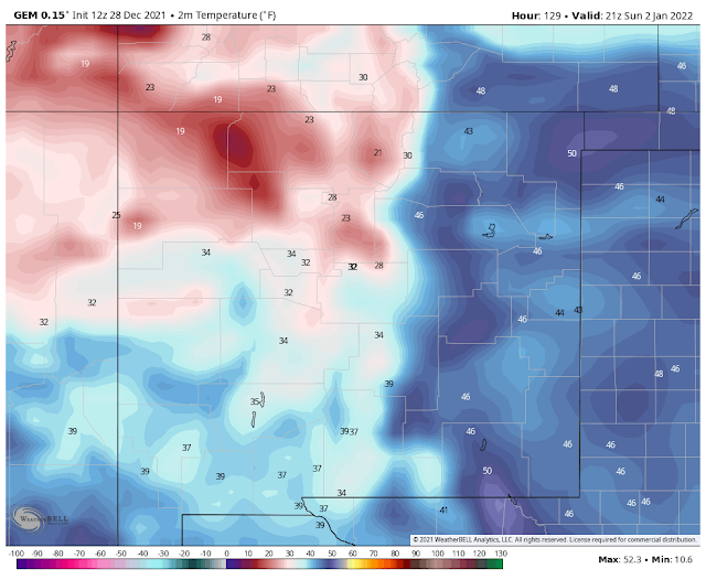
This morning's run of the Candian forecast model (GEM) has the coldest temperatures for the New Year's weekend. However, the other models aren't that much warmer than what you see above.
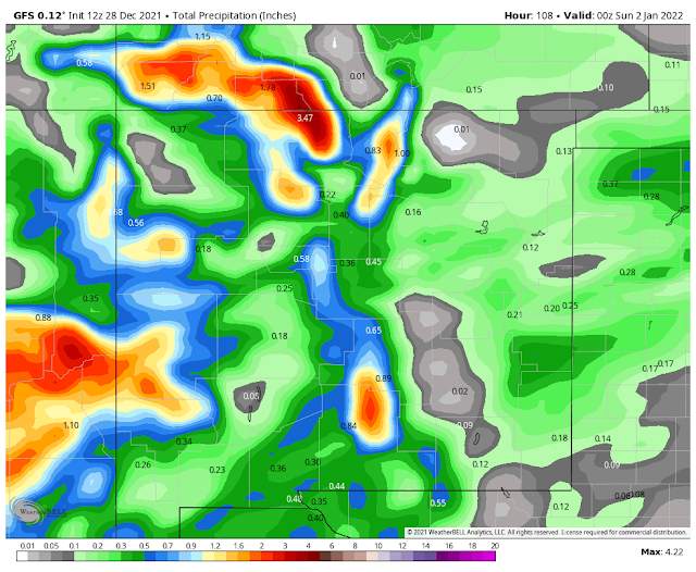
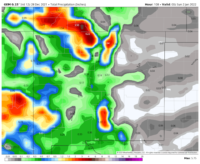
Storm Total Rainfall Forecast Amounts.
(Today Through New Year's Day).

U.S. GFS.
Canadian (GEM).
German (ICON).

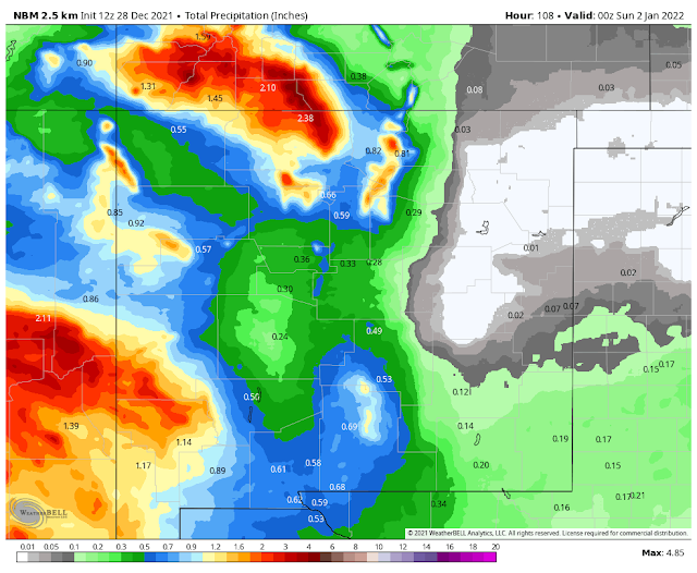
One thing that the models are pretty close on is that this incoming winter storm will drop it's heaviest precipitation over the mountains of the state.
As of this writing (Tuesday early afternoon), it appears that the Southeastern Plains will only get a quarter of an inch of rain or less. Remember this could change depending upon the storm track and timing. Rain showers are currently forecast to break out Thursday night and continue into Friday.
As of this writing (Tuesday early afternoon), it appears that the Southeastern Plains will only get a quarter of an inch of rain or less. Remember this could change depending upon the storm track and timing. Rain showers are currently forecast to break out Thursday night and continue into Friday.
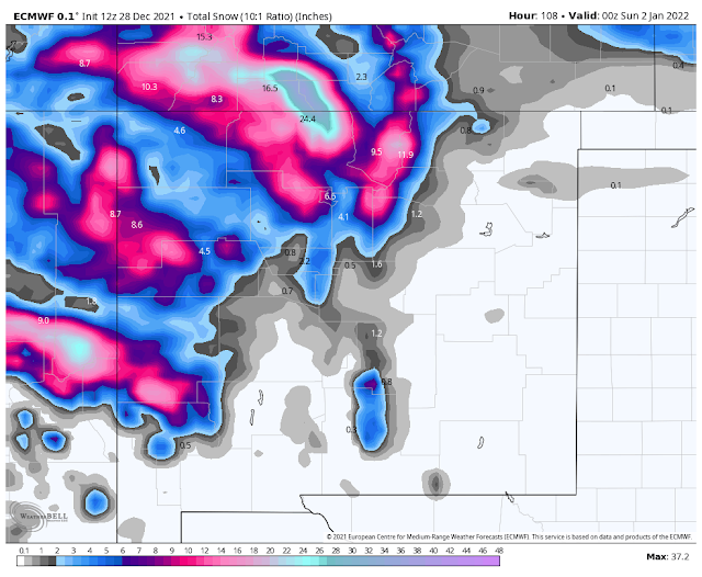
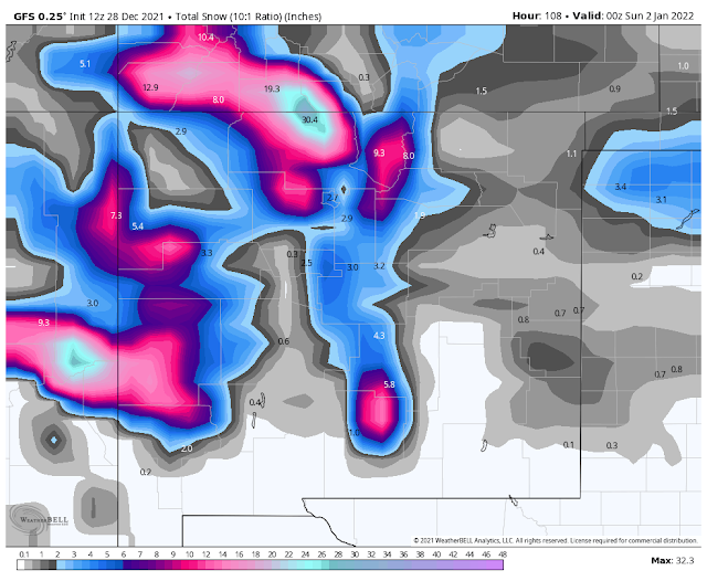
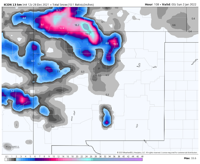
Storm Total Snowfall Forecast Amounts.
(Today Through New Year's Day).
U.S. GFS.
Canadian (GEM).

German (ICON).
National Blend Of Models (NBM).
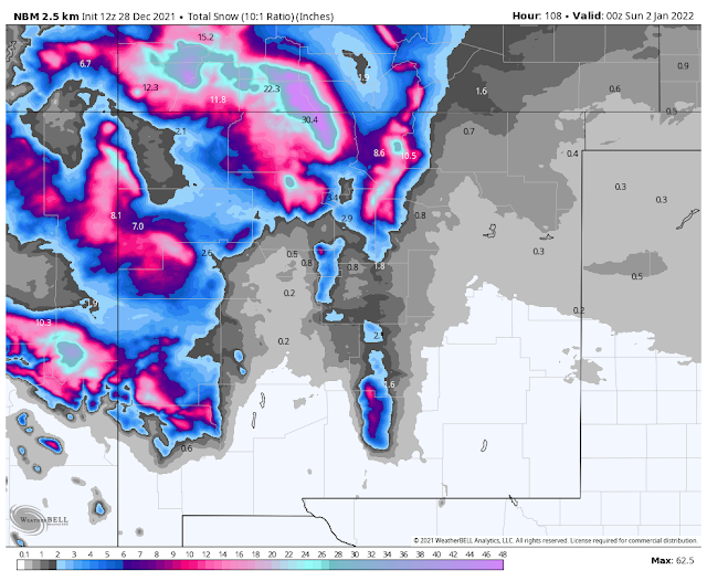
Another thing that the models are predicting is that this will be a significant snow producer for the state's mountains. Especially across western and northern New Mexico. How much snow falls over the Capitan, Sacramento, and Guadalupe mountains? Good question and for now it looks like above 7,000' anywhere from 6" to a foot will be possible. Maybe much higher above 8,000 to 9,000'.
Snow levels on Friday currently look to be high generally around 8,000'. Friday night snow levels will drop down to around 5,000' to 6,000'. There is the potential for this storm to produce heavy to very heavy snow in the Sacramento and Capitan mountains.
Snow is currently (as of Tuesday) forecast to spread across the Sacramento mountains Thursday night into New Year's Day. Scattered snow showers of the off-and-on variety will occur today through Thursday.
Snow is currently (as of Tuesday) forecast to spread across the Sacramento mountains Thursday night into New Year's Day. Scattered snow showers of the off-and-on variety will occur today through Thursday.
By the time the colder air arrives behind the frontal passage on New Year's Day the precipitation will be coming to an end across the Southeastern Plains. So for now it seems our chances for accumulating snows are very low.
High Wind/Blowing Dust Event New Year's Eve & Day.

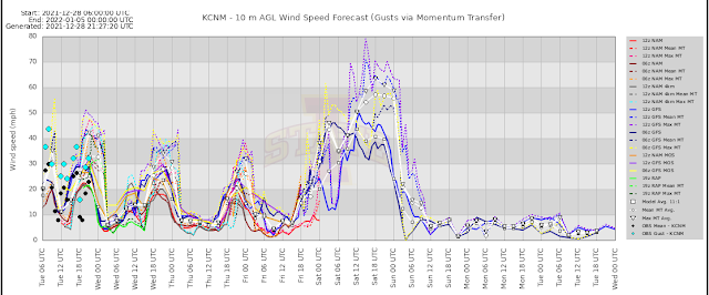
High winds will once again plague the mountains today through Wednesday evening, while breezy to windy conditions will exist at the lower elevations. New Year's Eve and New Year's Day will see another high wind and blowing dust event area-wide as our winter storm takes aim on the state. Today's Bufkit Meteogram Generator (Iowa State) forecast models are forecasting gusts in the 60-80 mph range for Carlsbad on New Year's Day.
Local National Weather Service Forecasts.
Take a look at Cloudcroft's New Year's Eve and New Year's Day forecast above...west-southwest winds sustained at 28 to 33 mph with gusts near 60 mph with a low temperature of 19ºF. That produces a wind chill value of -1ºF. Gusts are not normally factored in when considering wind chill values but a gust of 60 mph with a temp of 19ºF produces a wind chill of -21ºF. With a forecast high temperature on New Year's Day of only 23ºF, and sustained winds of 34-39 mph with gusts near 60 mph...that wind chill will be just as brutal.
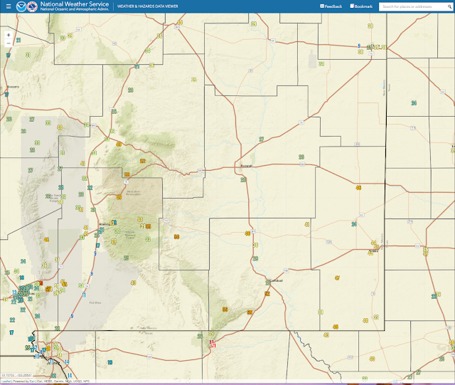
NWS MesoWest Reported Peak Wind Gusts.
Sunday.
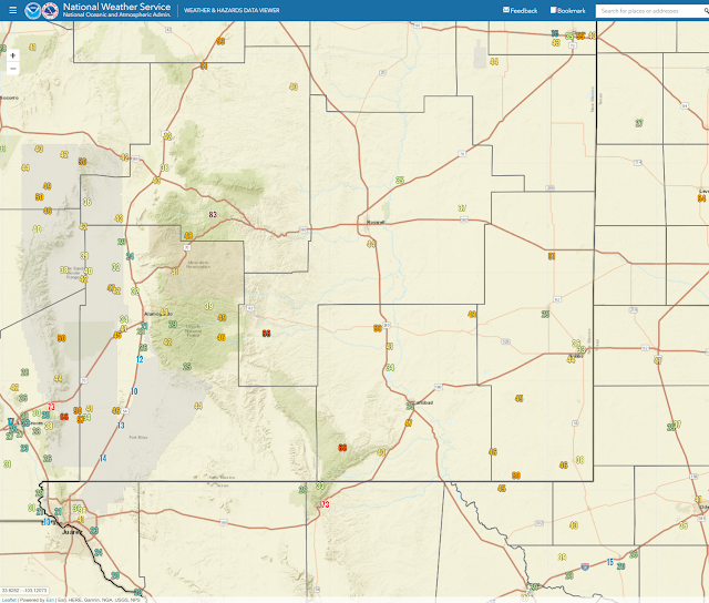
Monday.
Tuesday.
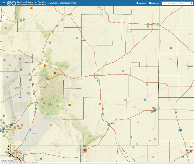
Local Reported Peak Wind Gusts.
Sunday.
Sunday, Dec 26th the following peak wind gusts were recorded:
Sierra Blanca Regional Airport northeast of Ruidoso: west-southwest winds are sustained at 56 mph with gusts to 82 mph.
The Bowl Raws north of Guadalupe Peak 79 mph.
Pine Springs Raws in the Guadalupe Mtn's Natl Park 73 mph.
Buck Mountain PWS (10,676') northwest of Ruidoso 70 mph.
Dunken Raws 66 mph.
White Sands Missile Range Headquarters 63 mph.
Capitan PWS 62 mph.
San Augustin Pass east of Las Cruces 59 mph.
Clines Corners ASOS 54 mph.
Guadalupe Pass 54 mph.
Nogal PWS 54 mph.
Tuesday.
As of 2:00 PM MST this Tuesday morning the following peak gusts have been recorded:
If you are planning on traveling through Guadalupe Pass or the Sacramento and Guadalupe mountains today ..use extra caution because of high winds.
The Bowl Raws just north of Guadalupe Peak 81 mph.
Pine Springs Raws 71 mph.
Once again the Guadalupe Pass ASOS is down (this is getting ridiculous) so no reports there.
San Augustin Pass on US Hwy 70 east of Las Cruces 68 mph.
Bat Draw Raws at Carlsbad Caverns 59 MPH (at 12:52 AM MST).
The Smokey Bear Raws in Ruidoso 58 mph.
The Queen Raws 56 mph.
The Mayhill Raws 55 mph.
Carlsbad Airport ASOS 52 MPH (1:05 AM MST).
Dunken Raws 50 MPH.
The Sierra Blanca Regional Airport northeast of Ruidoso 52 mph at 12:15 AM MST (just after midnight).
Note: On Sunday the Sierra Blanca Regional Airport located northeast of Ruidoso clocked a peak gust of 83 mph.
The Truth Is Stranger Than Fiction!


Comments
Post a Comment
Your comments, questions, and feedback on this post/web page are welcome.