

A Series Of Western Storms Will Just Dump On The Sierra Nevada!
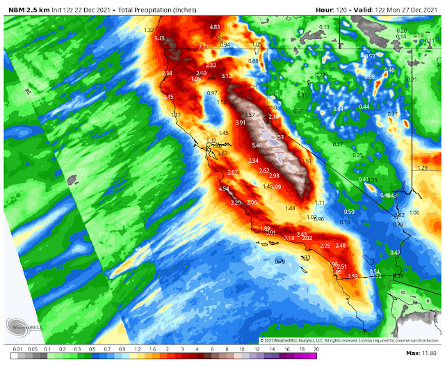
National Blend Of Models (NBM) 5-day Storm Total Precipitation Forecast.
A Series Of Western Storms Will Just Dump On The Sierra Nevada!
Over the next week, a series of powerful Western U.S. winter storms will just dump on the Sierra Nevada Mountains and nearby areas. This is one of those events that you just sit back and marvel at...and one for the record books too!
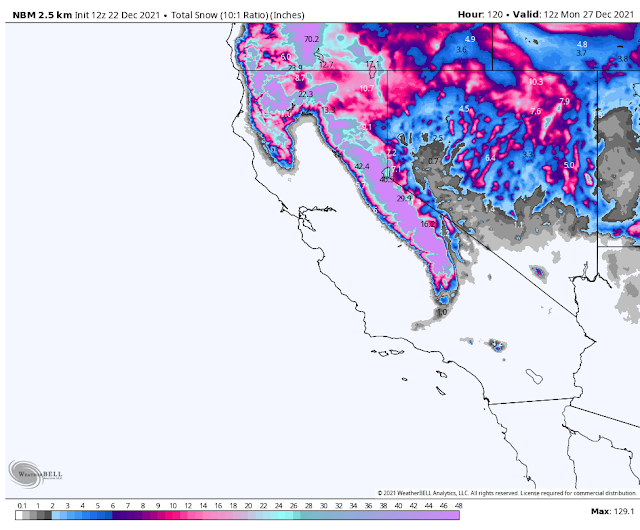
Over the course of the next five days (today through next Monday morning) the National Blend of Models (NBM) is forecasting 129" of snowfall (just short of 11 feet) and nearly 12" of rain for areas highlighted above. Through in some mountain wind gusts of 85 mph at the higher elevations and you have the makings of a historic set of winter storms...blizzards.
Over the course of the next five days (today through next Monday morning) the National Blend of Models (NBM) is forecasting 129" of snowfall (just short of 11 feet) and nearly 12" of rain for areas highlighted above. Through in some mountain wind gusts of 85 mph at the higher elevations and you have the makings of a historic set of winter storms...blizzards.
This Mornings Reno, NV Area Forecast Discussion (AFD).
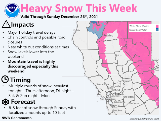
 Area Forecast Discussion
  National Weather Service Reno NV
  231 AM PST Wed Dec 22 2021

  ...MAJOR TRAVEL DISRUPTIONS THROUGH THE HOLIDAY WEEKEND...

  .SYNOPSIS...

  Stormy weather continues this with rain and snow, mainly for the
  Sierra and northeast California. Be prepared for major travel
  disruptions and delays over Sierra passes, especially Thursday. Be
  prepared for winter travel conditions as heavy snow will continue in
  the Sierra through most of the holiday weekend, with chances for
  accumulating snow down into western Nevada valleys Friday.

  &&

  .SHORT TERM (Through Wednesday Night)...

  The main message remains the same, "Travel across the Sierra will be
  difficult to impossible at times through the holiday weekend".

  . Snow which had already started over NE California and progress
    south into the higher elevation areas around the Lake Tahoe Basin.
    Impacts over Donner Summit/Carson Pass should continue through
    Wednesday into Thursday morning.

  This first system is the short delay of colder air and precipitation
  into the West Coast as the upper trough splits and flattens the
  upper ridge that stubbornly shifts east in the central Rockies. Much
  of the stronger forcing will lift northeast into OR, but enough
  forcing will remain to complement the weak isentropic lift into the
  Sierra, northeast CA, and for northwest NV.

  Snow levels may start low this morning at ~4500-6000 feet as
  precipitation moves into the region with colder air still trapped in
  many valleys. Through Wednesday, a gradually increasing southerly
  flow may push snow levels as high as 7000-7500 feet over the much of
  the Sierra south of I-80 to include the Lake Tahoe Basin. The rising
  snow levels may only bring light snow to the lower elevations of NE
  California and the Tahoe Basin. Snow levels are currently expected
  to peak Wednesday afternoon below descending slowly through
  Wednesday night into Thursday morning. Above about 7000` we should
  still see around foot or so of new snow with more on the way.

  Although much the Reno area will be largely spared during this first
  winter system, most areas below 6000 feet will see mostly rain. But
  there is a slight chance surrounding higher foothill areas could
  receive up to an inch of accumulated snow early Thursday morning as
  snow level start to slowly inch across the region.

  In western Nevada, expect breezy winds over most areas with
  increased chances of rain showers spreading into the rest of Western
  Nevada Wednesday afternoon through Thursday as this first impulse
  moves further inland. Winds across the Sierra crest will be howling
  from the southwest 75-85 mph. -Amanda

  .LONG TERM (Thursday Onward)...

  ...Main Takeaways Upfront...

  1. The forecast remains on track to see several rounds of
  significant snowfall, eventually spreading into Western NV by
  Friday.

  2. Major travel impacts with very long delays and possible road
  closures across Sierra and NE California passes. Hazardous driving
  conditions may persist over higher elevation roadways even if
  temporary breaks in snowfall intensity occurs. Chain controls are
  almost guaranteed, so do not attempt traversing the Sierra through
  early next week without being properly prepared for winter
  weather.

  3. Check your flight status regularly and be sure your patience
  is packed in the suitcase. Consider downloading apps for CALTRANS
  and NDOT (QuickMap and NVRoads, respectively) and frequently check
  road conditions before venturing out.

  4. While spillover precipitation is likely to occur into western
  NV by Thursday morning, this is expected to be rain due to high
  snow levels until colder air arrives on Friday. Expect winter
  driving conditions into lower valleys to be possible through the
  weekend.

  5. Very chilly temperatures look to arrive for New Years weekend
  with widespread highs at or below freezing.

  ...Nitty-Gritty Details...

  By the start of the period Thursday morning, hi-resolution models
  agree on the initial push of spillover precipitation into Western
  NV to begin around this time. This is not to say that periodic
  bouts of rain showers and high elevation snow will not occur in
  the short-term. It just suggests the strongest mid-level winds
  (with orthogonal trajectory to the Sierra), moisture push, and
  forcing out ahead of the upper level trough will result in more
  favorable spillover set up. Consequently, this is when we expect
  precipitation rates to get cranking in the Sierra, which is
  reflected by the start time of the upgrade from Winter Weather
  Advisory to Winter Storm Warning for Greater Tahoe Area and
  Northeast CA.

   -Caveat time... Snow levels do not look super impressive to start
    with,as southerly warm air advection looks to keep things
    ranging from 6000ft across NE CA to 6500-7000 across Tahoe Basin
    to 7500 for the Eastern Sierra. This makes Thursday morning a
    troublesome forecast as Mono county and the eastern Sierra
    should see very intense snowfall rates, but snow levels will be
    right around I-80 pass level and likely just above Lake Tahoe
    level. Probabilistic snow-level guidance keeps Donner pass right
    around a 50/50 shot of being all snow (with periodic mixing at
    times) and just about no chance of snow at lake level (should be
    rain, with perhaps some mixed precip at times).

  As the upper level trough approaches the region, colder air will
  get pushed into the area through the day on Thursday, resulting
  in a gradual trend downward in snow levels. BY Thursday afternoon,
  those north of US-50 should see snow levels between 5000-6000ft
  from north to south. Outside of Sierra ridges, the strongest winds
  at this time look to be down south across the 395 corridor in
  Mono county, in addition to northern Washoe. Nothing blockbuster,
  but it could result in areas of blowing snow and reduced
  visibility...

  Snow levels will crash as the cold front approaches the region
  Thursday night. We should see a full transition to snow for the
  lower valleys by Friday morning, with nothing really suggesting
  they will rise above valley floors through the remainder of next
  week so they will no longer be a major forecast concern...

  As suggested in previous forecast issuance, the biggest concern
  for widespread (all of NE California and Western Nevada) travel
  impacts will start Friday, as model consensus is in rather good
  agreement of accumulating snowfall in the lower elevations
  starting this time. It is challenging to pinpoint a clear-cut
  break in the action at any point through Tuesday, as no ensemble
  cluster is in good agreement as far as timing goes. In other
  words, GFS ensemble provides a slight break both Saturday morning
  and especially Monday afternoon where as European ensemble shows a
  lull late Friday night and Sunday evening. It`s worth noting that
  all ensemble clusters have high-end "tails" through these time
  periods, hence the difficulty in saying with certainty when we
  will see a break in precipitation. It`s best to prepare for some
  level of impacts through this entire time period and we should get
  better ideas in the coming days of when breaks in the action, if
  any, can be anticipated.

  Greatest chance for strong to even damaging winds will arrive
  Sunday, with about a 30-40% chance damaging winds (60mph or
  greater) across Surprise Valley, 30% along US-395 in Washoe
  Valley, and a 40% chance along US-395 between Topaz Lake and
  Bridgeport. It`ll officially be after Christmas, so your
  decorations may not be able to hangout through New Years...

  A couple of slider-like systems look to drop into the region from
  the north next region Monday, Wednesday, and again on Friday. The
  coldest signals are Wednesday and Friday, however. Each of these
  will bring an additional shot of snowfall along with reinforcing
  cold air. If you dislike chilly temperatures now will be the time
  to take that trip to Florida you`ve been promising your kids. All
  of us may struggle to get above freezing through all of next
  weekend. Brr

  -Dustin

  &&

  .AVIATION...

  LLWS and moderate turbulence due to mountain waves for all terminals
  will persist through Wednesday night.

  A series of systems that approach the area will bring rounds of
  heavy mountain snow. Visibilities will be diminished greatly with
  mountain obscuration likely and periods of LIFR/IFR for KTRK and
  KTVL the remainder of this morning into Wednesday night. For the
  valleys and terminals such as KRNO, KCXP, and KMEV, light to
  moderate precipitation could be in the form of rain/snow transitions
  at times on Thursday.

  Flight conditions will include icing issues and wind gusts that will
  create moderate to severe turbulence and LLWS. Friday, snow levels
  will drop to valley floors, bringing increased chances of snow to
  all terminals.

  -Amanda

  &&

  .REV Watches/Warnings/Advisories...
  NV...Winter Weather Advisory until 4 AM PST Thursday NVZ002.

       Winter Storm Warning from 4 AM Thursday to 4 PM PST Sunday
       NVZ002.

  CA...Winter Weather Advisory until 4 AM PST Thursday above 5000 feet
       in CAZ071.

       Winter Storm Warning from 4 AM Thursday to 4 PM PST Sunday
       CAZ071.

       Winter Storm Warning from 4 PM this afternoon to 4 PM PST Sunday
       CAZ073.

       Winter Weather Advisory until 4 AM PST Thursday CAZ072.

       Winter Storm Warning from 4 AM Thursday to 4 PM PST Sunday
       CAZ072.

  &&


 For more information from the National Weather Service visit...
 http://weather.gov/reno
The Truth Is Stranger Than Fiction!


.png)


Comments
Post a Comment
Your comments, questions, and feedback on this post/web page are welcome.