

Dangerous High Wind/Blowing Dust Event For This Christmas Eve!

December 19, 2021.
Instead of icicles, snowmen, and a White Christmas this year we are getting tumbleweeds, needle grass, blowing dust, and high winds. This Christmas Eve will be one to remember weather-wise and not in a good way either. A very dangerous high wind event with Critically Dangerous Fire Weather Conditions for a small part of the Southeastern plains and parts of West Texas.
Storm Analysis This Christmas Eve Morning.


(At 12Z or 5 AM MST This Morning).
Forecast models indicate that our inbound Christmas Eve Winter Storm has tracked a little further south than they have been forecast for the past couple of days. This is important because it means that more of New Mexico will see lowland rain showers and high mountain snows. But not across Eastern and Southeastern New Mexico.
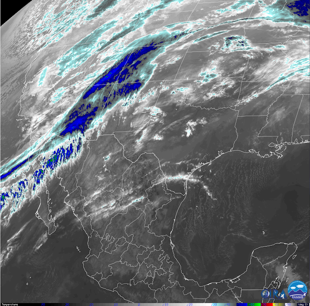
Regional radar and satellite images this morning show a band of layered clouds stretching from southwest of the Baja California Region northeastward to the Four-Corners. Embedded within this band are lowland rain showers and high mountain snow showers. This activity will spread eastward today as a Pacific cold front moves southeastward across the state this afternoon and evening.
A shortwave trough of low pressure at the mid-levels will sweep across the state today. A surface low will develop over southeastern Colorado setting the stage for a tight surface pressure gradient across the area this afternoon.
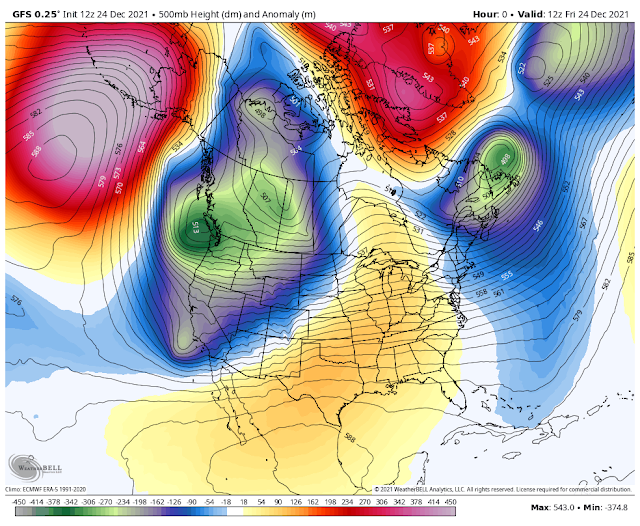
By this afternoon winds at the 700 millibar (10,000') level are forecast to be in the 60-80 knot or 69-92 mph range. At the 500 millibar (18,000') level these winds are forecast to be in the 100-120 knot or 115-138 mph range. With a 300 millibar (30,000') jet stream wind speed max overhead of 130 knots or 150 mph. What all of this means is that as the atmosphere at the surface heats up as the day progresses, this warming or mixing will interact with these very strong winds aloft. Meaning that as these high winds aloft get mixed down, or pulled down to the mountains and plains the result will be dangerous wind gusts.
High Wind Warnings, Wind Advisories, and Red Flag Warnings are in effect for all of the local area today through this evening. We get somewhat of a break on Christmas Day but another high wind event is on tap for Sunday. Another break occurs Monday with a repeat Tuesday. And looking down the road into the New Years' weekend yet another Winter Storm will be impacting the state.
Long-range forecasts have been calling for a pattern change in our weather and thus we see this today with storm #1.
Temperature-wise we may see a number of local daily high-temperature records for Christmas Eve tumble today. There even could be a few locations that tie or break their all-time record highs for the month of December. High temps today will average some 15 to 25-degrees above normal.
Dangerous Christmas Eve High Wind/Blowing Dust Event!
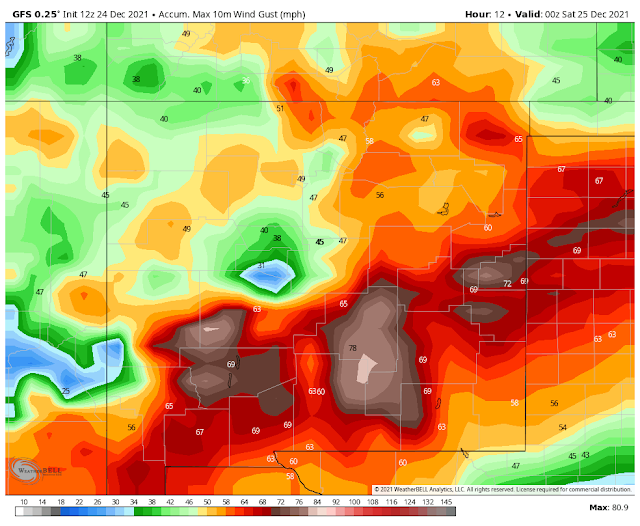
Concerns are high this morning over today's high wind event. High Wind Warnings that are in effect for the state and local area call for the following:
South Central Mountains including the Cloudcroft, Sunspot, Mayhill, Weed/Sacramento, Timberon/Pinon, Elk, and Dunken areas. West winds becoming sustained at 35 to 45 mph with gusts over 70 mph! Some damages to roofs, west-facing windows, power poles and lines, outbuildings/sheds, and trees may occur today.
South Central Mountains including the Cloudcroft, Sunspot, Mayhill, Weed/Sacramento, Timberon/Pinon, Elk, and Dunken areas. West winds becoming sustained at 35 to 45 mph with gusts over 70 mph! Some damages to roofs, west-facing windows, power poles and lines, outbuildings/sheds, and trees may occur today.
Will this high wind event be as bad as the Cloudcroft March 13th, 2019 event? I sincerely hope not but the potential is there. One thing that may prevent this is that band of clouds and rain and snow showers approaching from the west. Clouds inhibit or prevent somewhat the mixing of the atmosphere. Along with a chance for rain and snow showers. This may or may not limit how high these winds get today. Snow levels will remain high today, above 10,000' lowering tonight to around 7,000'. Cloudcroft has a 60% chance of rain showers this afternoon and a 50% chance of rain or snow showers this evening.
South Central Mountains including the Picacho, Ruidoso, Capitan, Mescalero, and the Dunken areas. West winds becoming at 35 to 45 mph with gusts over 70 mph! Some damages to roofs, west-facing windows, power poles and lines, outbuildings/sheds, and trees may occur today. In fact, as of 10:15 AM MST, the Sierra Blanca Regional Airport northeast of Ruidoso has west-southwest winds sustained at 45 mph with gusts to 64 mph.
Southeastern Plains Forecast.
Southwest winds will become sustained at around 35-45 mph with gusts to 60 mph. Some higher gusts will be possible especially in the normally wind-prone areas such as near or over the foothills.
The Guadalupe Mountains including the Queen, Pines Springs, and Guadalupe Pass areas. West winds of 40 to 50 mph with gusts of 75 mph or possibly higher. The Bowl Raws has already reported a peak gust to 71 mph.
Areas of blowing dust will develop reducing the visibility. Localized areas of blowing dust will suddenly with little warning reduce the visibility down to zero in the following areas: Exposed or freshly plowed farmlands, fields, lots, Pecan Orchards, highway construction sites.
Of concern, area-wide is the potential for localized wind damage to roofs, west-facing windows, power poles and lines, outbuildings/sheds, farm irrigation equipment (sprinkler systems) and trees may occur today.
Of concern, area-wide is the potential for localized wind damage to roofs, west-facing windows, power poles and lines, outbuildings/sheds, farm irrigation equipment (sprinkler systems) and trees may occur today.
Of concern is the potential for wildland fires, grass fires, and forest fires during the high winds. Any fire that develops will have the potential to rapidly spread and grow.


(Today Through 5 AM MST Monday).

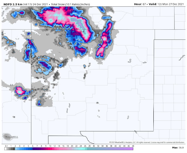
NWS NDFD Storm Total Precipitation Forecast.
(Today Through 5 AM MST Monday).
The Truth Is Stranger Than Fiction!


Comments
Post a Comment
Your comments, questions, and feedback on this post/web page are welcome.