

Major Winter Storm Still On Track To Hammer New Mexico - Especially The Mountains
December 26, 2021.
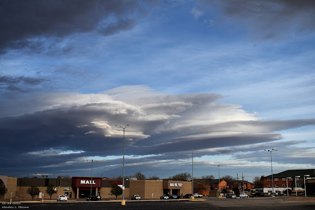
Carlsbad, New Mexico.
Stacked Altocumulus Standing Lenticular Clouds.
Still On Track For A Major Winter Storm!
(At 11 AM MST Thursday).
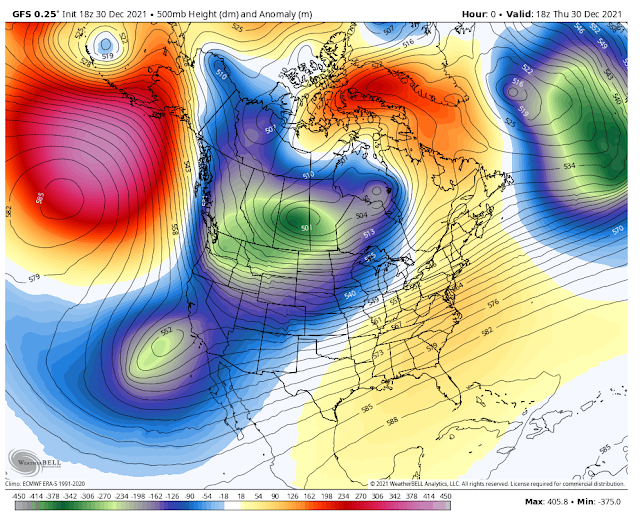
GFS 500 MB (18,000') Forecast.
(Valid At 11 AM MST Friday).
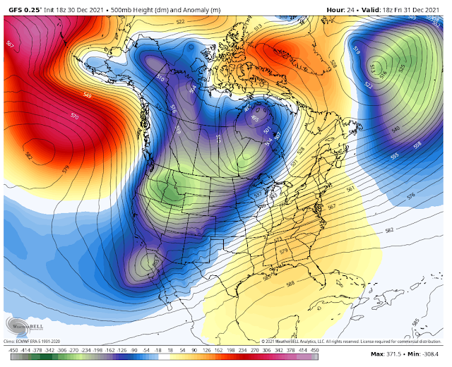
GFS 500 MB (18,000') Forecast.
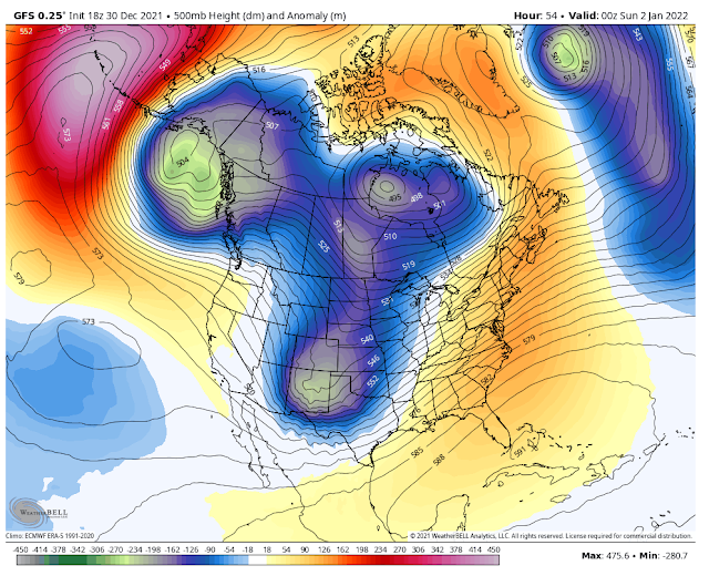
(Valid At 5 PM MST New Year's Day).
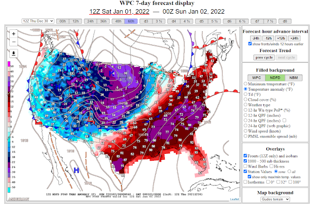
Just as I mentioned in yesterday's blog the computer forecast models are slowing our incoming winter storm down a little bit. This morning's 11 AM MST run of the U.S. GFS model is also digging the long-wave trough of low pressure a tad further south on New Year's Day. All this means is that the arrival of the coldest air across our local area won't occur until late Friday afternoon and evening. And with a slower-moving storm, the potential for heavier rainfall and snowfall is reasonable.
Overall we may end up with a slower and stronger storm than what has been forecast the past couple of days. The models still forecast an abundant fetch of mid-level subtropical moisture to get pulled northeastward into the area from the Eastern Pacific Ocean. In fact, forecast soundings over southern New Mexico indicate near-record high moisture levels in the atmosphere for this time of the year as per the El Paso/Santa Teressa National Weather Serice Office discussion this afternoon. After one of the driest falls on record, this is good news for the area and especially the mountains.
Overall we may end up with a slower and stronger storm than what has been forecast the past couple of days. The models still forecast an abundant fetch of mid-level subtropical moisture to get pulled northeastward into the area from the Eastern Pacific Ocean. In fact, forecast soundings over southern New Mexico indicate near-record high moisture levels in the atmosphere for this time of the year as per the El Paso/Santa Teressa National Weather Serice Office discussion this afternoon. After one of the driest falls on record, this is good news for the area and especially the mountains.
(New Year's Day).
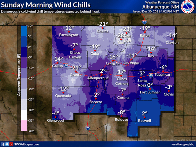
Note the forecast high temperatures in the teens for eastern Colorado and Kansas on New Year's Day. Wind chill values across New Mexico are going to be brutal New Year's Night into Sunday morning adding to the misery factor of anyone who will be outdoors.
Dangerous Wind Chill Values.
(Valid At 5 AM MST Sunday).
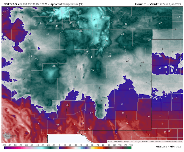
Apparent temperatures are similar to wind chill temperatures but include the humidity factor so these values can be lower than the wind chill.
We will see wind chill/apparent temperature values drop down into the near-zero and the single digits across Southeastern New Mexico New Year's Night into Sunday morning.
We will see wind chill/apparent temperature values drop down into the near-zero and the single digits across Southeastern New Mexico New Year's Night into Sunday morning.
These values will drop down into the single digits on New Year's Eve night. And sub-zero values across the Sacramento and Capitan mountains on New Year's night into early Sunday morning. Maybe even as low as -5ºF to -15ºF. These values will be in the dangerous category. Southwest winds are forecast to gust up to around 45-55 mph over the Sac's and Capitan's New Year's Eve into New Year's night.
Low temperatures Sunday morning over northern New Mexico are forecast to be in the -10ºF to -20ºF range. Apparent temperatures in some locations there will be around -30ºF.
Low temperatures Sunday morning over northern New Mexico are forecast to be in the -10ºF to -20ºF range. Apparent temperatures in some locations there will be around -30ºF.
Description given in the National Digital Forecast Database (NDFD) Documentation: Apparent Temperature: The perceived temperature in degrees Fahrenheit derived from either a combination of temperature and wind (Wind Chill) or temperature and humidity (Heat Index) for the indicated hour. When the temperature at a particular grid point falls to 50 F or less, wind chill will be used for that point for the Apparent Temperature. When the temperature at a grid point rises above 80 F, the heat index will be used for Apparent Temperature. Between 51 and 80 F, the Apparent Temperature will be the ambient air temperature. NWS NDFD Forecast High/Low Temperatures. New Year's Eve Morning Lows. 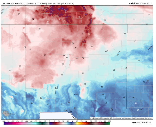 New Year's Eve Daytime Highs. 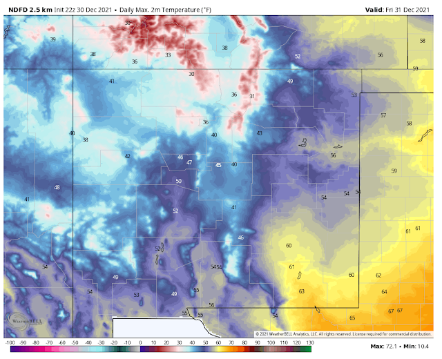 New Year's Morning Lows. 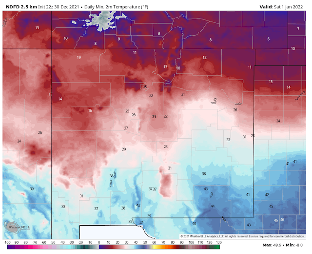 New Year's Day Highs.  Sunday Mornings Lows.  Sunday's High Temps. 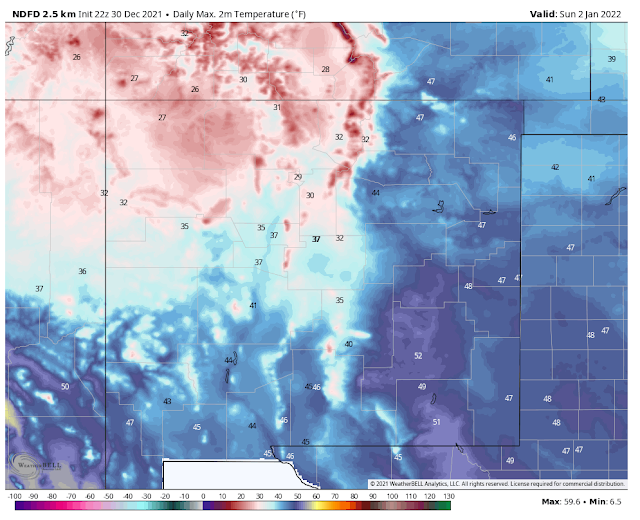 Low temperatures across the Southeastern Plains Sunday morning are forecast to be in the teens. I still won't be surprised to see a few of our normally colder valley locations drop down into the single digits. Lows across the Sacramento and Capitan mountains Sunday morning are forecast to be in the single digits with some of the normally higher colder mountain valleys dropping below zero. How Much Rain & Snow? 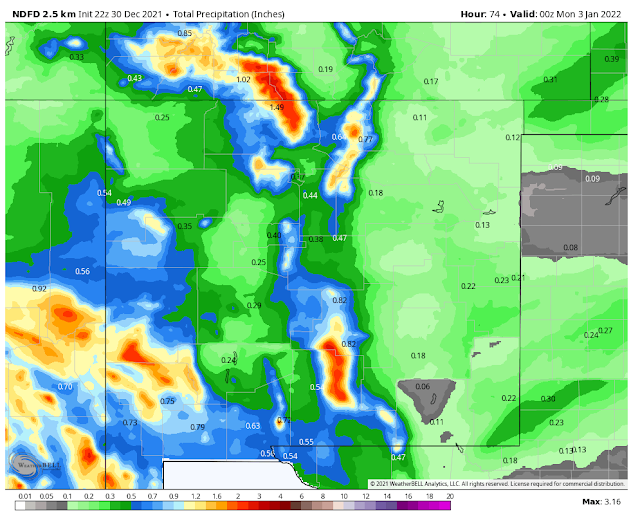 The latest model forecasts continue to call for a quarter of an inch of rain or less for the Southeastern Plains from this storm. I think that this may be underdone somewhat. Parts of the local area may end up with more. NWS NDFD Storm Total Snowfall Forecast. 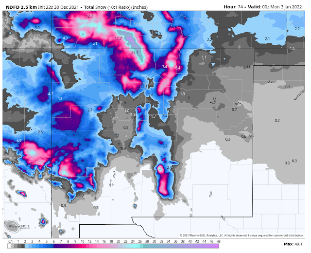 Major Winter Storm For The Mountains! Numerous Winter Storm Warnings, Watches, and Winter Weather Advisories continue in effect for many areas of western, northern, and central New Mexico from tonight into New Year's Day. An Avalanche Watch remains in effect for parts of the northern mountains as well. Please visit the Albuquerque National Weather Service Office for the details via the link. Winter Storm Watches are in effect for the northern and southern Sacramento mountains from New Year's Eve morning through New Year's Day. Snow levels tonight are forecast to drop down to around 7,500' tonight over the Sacramento and Capitan mountains. Cloudcroft may get 1" - 3" by New Year's Eve morning. Snow levels rise up to 8,500' to 9,000' on New Year's Eve Day. Cloudcroft may see a rain/snow mix until late in the day. Snow levels on New Eve Night start out at around 8,000' then drop down to around 6,000' later in the night. Snow levels on New Year's Day are forecast to be around 7,000' then lowering through the night. Generally, locations across the Sac's and Capitans expect the following storm total snowfall amounts by Sunday morning: Below 6,000' less than 3". (Dunken, Pinon, Picacho, Carrizozo areas). 6,000' to 7,500' 4" to 8". (Elk, Mayhill, Weed, Sacramento, Timberon, Mountain Park, Ruidoso Downs, Capitan, Nogal, Mescalero areas). Above 7,500' 6" to 12". (Upper Ruidoso, Alto, Wimsatt, Cloudcroft, Silver Lake, Bonito Lake areas). Locally up to 15 - 18" possible above 8,000'. Highest peaks (Sunspot, Ski Apache, Capitan Mountains above 8,000'). 24" - 30". Blowing Snow & Drifting Snow Will Cause Travel Problems! Snow heavy at times along with blowing snow, drifting snow, and dangerously low visibilities and white-out conditions will cause significant travel problems over New Mexico's mountains and nearby areas tonight into Sunday morning. Some locals may even experience blizzard conditions at times. This includes the Sacramento and Capitan mountains where southwest winds are forecast to gust up into the 45-55 mph New Year's Eve into New Year's night. Many roads in the advisories areas of the state including the Sacramento and Capitan mountains will see difficult to impossible driving conditions. Expect road closures in some areas. Please heed all watches, warnings, and advisories. This winter storm will have major impacts on parts of the state. A high wind event is still forecast for the Southeastern Plains New Year's Eve night into New Year's Day. High Wind Warnings and Watches are already in effect for the Guadalupe mountains. I expect to see additional high wind watches and warnings locally...issued tomorrow. Current thinking is that southwest winds may gust up to around 55-65 mph New Year's Eve Night into New Year's Day. Should the Southeastern Plains get more rain than is currently forecast this will help to dampen the high winds and minimize the blowing dust. If not we are looking at another blowing dust event with the high winds. New Mexico Highway & Road Information.
|
The Truth Is Stranger Than Fiction!


.png)


A very delightful article that you have shared here.Windstorm Damage Your blog is a valuable and engaging article for us, and also I will share it with my companions who need this info. Thankful to you for sharing an article like this.
ReplyDelete