

First Significant/Major Winter Storm Of The Season Just In Time For The New Year's Holiday Weekend!
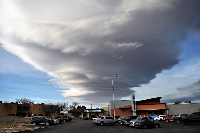
December 26, 2021.
Carlsbad, New Mexico.
Stacked Altocumulus Standing Lenticular Clouds.
First Significant/Major Winter Storm Of The Season Just In Time For The New Year's Holiday Weekend!
( At 11 AM MST This Wed Dec 29, 2021).
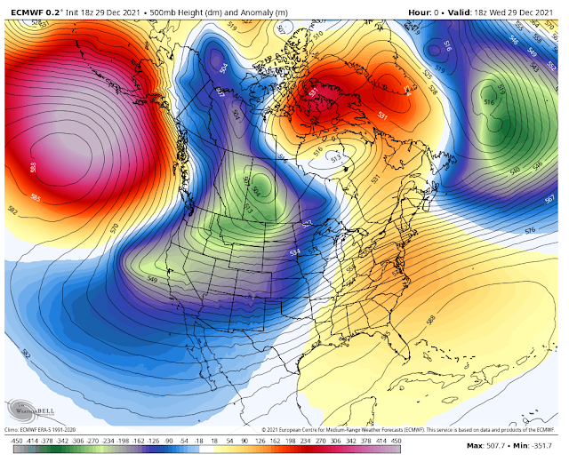
European (ECMWF) 500 MB (18,000') Forecast.
( Valid At 11 PM MST Thursday, Dec 30, 2021).
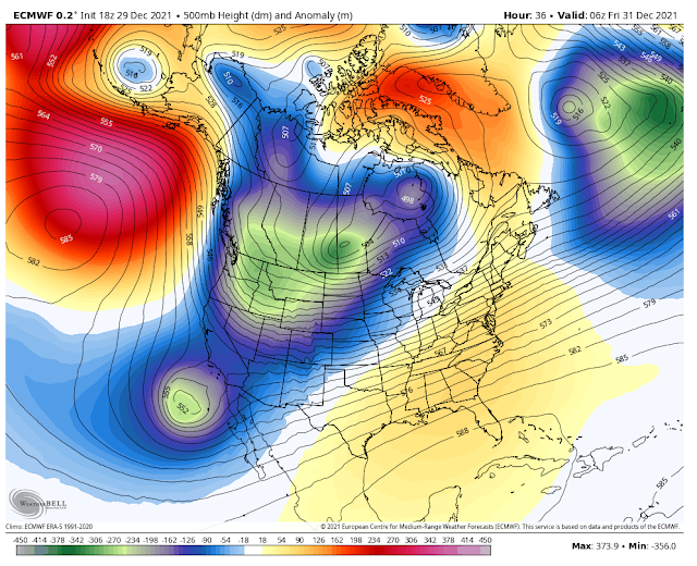
European (ECMWF) 500 MB (18,000') Forecast.
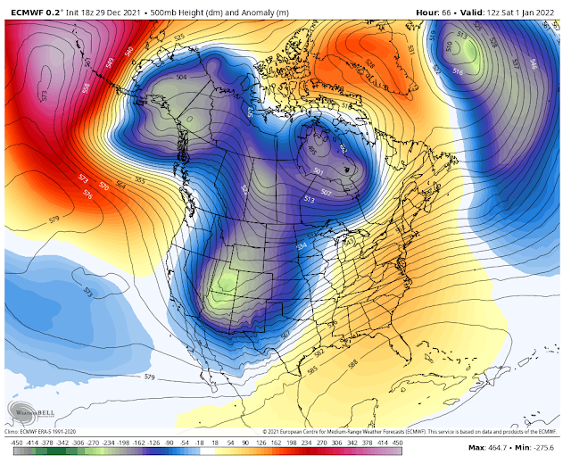
( Valid At 5 AM MST New Year's Day, Jan 1, 2022).
For those of you who have been reading my weather blog posts for a while now know that most of the time I start out by looking at the mid-upper levels of the atmosphere. This generally means from about 10,000' up through about 40,000'. Because this is where most storms form. I usually pick the 500 millibar level or the 18,000' level like depicted in the maps above because this is roughly halfway up into our atmosphere. The jet stream generally resides between about 18,000' to 40,000'. Give or take a few thousand feet depending on how deep a storm or trough is.
Today's 11 AM MST run of the European model seems to have the best handle on how our developing winter storm will impact New Mexico including our local areas Thursday into New Year's Day. So I'm using its forecast maps for this blog.
First of all note the deep and unusually strong long-wave trough of low pressure stretching southward and southwestward from north of Alaska this morning, all the way to nearly the Hawaiian Islands.
The bottom part of this long-wave trough of low pressure at the 18,000' level is forecast to break off into a strong closed low southwest of San Diego by Thursday night. By New Year's Day, this closed low is forecast to get absorbed and pulled northeastward into the long-wave trough of low pressure approaching the Four Corners by sunrise New Year's Day.
Closed mid-upper level lows like cut-off lows are tricky when it comes to forecasting. They often don't behave the way the models forecast them to, which creates forecasting headaches. Will this one prove to be a headache? Time will tell. What this low is going to do is latch onto abundant mid and high-level moisture over the Eastern Pacific Ocean and sling it northeastward into the Desert Southwest as the winter storm approaches.
Surface Map Forecast.
(Valid New Year's Day).
A back door cold front is forecast to surge southward and southwestward down the eastern plains of New Mexico on New Year's Day. A much colder airmass will accompany this frontal passage. The front will arrive in Southeastern New Mexico New Year's night. Following the frontal passage, and the departing mid-upper level storm, Sunday morning will see some of the coldest low temperatures of the season locally and across New Mexico. Places like Angel Fire and other high northern New Mexico valleys may drop down into the -10ºF to -20ºF range Sunday morning. Locally across the Sacramento mountain's lows, Sunday morning are forecast to fall into the single digits. Don't be surprised of some locations bottom out below zero.


Highs Thursday.
Lows New Year's Eve Morning.
Highs New Year's Eve.
Lows New Year's Day.
Highs New Year's Day.
Lows Sunday Morning
Highs Sunday.
(Valid Thursday Through 5 AM MST Sunday).
This is going to be a fairly wet storm with decent rains across southern New Mexico below 6,000'. Southeastern New Mexico may get a little more than what the forecast map above shows.
(Valid Thursday Through 5 AM MST Sunday).
Heavy To Very Heavy Mountain Snows!
This winter storm is going to be a blessing to New Mexico's mountains where the higher peaks and valleys of the western and northern mountains are expected to get one to three feet.
Winter Storm Watches have been issued for western and northern areas of New Mexico, and the northern and southern Sacramento mountains of the state. The Winter Storm Watches for the Sacramento and Capitan mountains go into effect Thursday afternoon and continue through New Year's Day morning.
Locally these two Winter Storm Watches include the following locations and their expected snowfall amounts listed below:
Below 6,000' less than 3'. (Dunken, Pinon, Picacho, Carrizozo areas).
6,000' to 7,000' 3" to 6". (Elk, Mayhill, Weed, Sacramento, Timberon, Mountain Park, Ruidoso Downs, Capitan, Nogal, Mescalero areas).
Above 7,500' 6" to 12". (Upper Ruidoso, Alto, Wimsatt, Cloudcroft, Silver Lake, Bonito Lake areas).
Highest peaks (Sunspot, Ski Apache, Capitan Mountains above 8,000') one to two feet.
A mix of rain and snow will occur off and on Thursday into Thursday night, as snow levels fluctuate between 6,000' to 9,000' over the Sacramento and Capitan mountains. New Year's Eve will see snow levels generally around 9,000' during the day, then dropping Friday night.
Cloudcroft will see a mix of rain and snow on New Year's Eve day with a forecast high of 33ºF. Ruidoso is forecast to see rain on New Year's Eve Day with a forecast high of 44ºF. Snow levels will drop down to 6,000' or maybe a little lower during New Year's Eve night into New Year's Day.
Blowing and drifting snow will become a travel problem for the Sacramento and Capitan mountains on New Year's Eve night into New Year's Day. Some roads may become impassable and closed due to the heavy snow, blowing and drifting snow, and very low visibilities. In some places near zero with little to no warning. Localized blizzard conditions could develop and are not totally out of the question.
Blowing and drifting snow will become a travel problem for the Sacramento and Capitan mountains on New Year's Eve night into New Year's Day. Some roads may become impassable and closed due to the heavy snow, blowing and drifting snow, and very low visibilities. In some places near zero with little to no warning. Localized blizzard conditions could develop and are not totally out of the question.
Additional Winter Storm Watches and or Warnings and Winter Weather Advisories may be issued for the state for the Thursday night into New Year's Day time frame by our local National Weather Service Offices.
Southwest to west winds are forecast to gust between 45-60 mph over the Sacramento and Capitan mountains from New Year's Eve Day into New Year's Day. Locally higher gusts are possible across the higher mountain ridges and peaks.
Dangerous wind chill values down to near zero or below will also occur New Year's Eve night into New Year's Day. Some values may be as low as -5º to -10ºF at times across the higher elevations.
Low temperatures over the Sacramento and Capitan mountains Sunday morning will be in the single digits. Some of the normally higher colder mountain valleys may drop down below zero.
Low temperatures over the Sacramento and Capitan mountains Sunday morning will be in the single digits. Some of the normally higher colder mountain valleys may drop down below zero.
By the way, Ski Apache opened today with two of the lower slopes available using man-made snow. This storm will be a blessing for them.
Southeastern New Mexico.
This will be a mountain dream of a storm for those who love snow. As of this writing (Wednesday evening) not so for the Southeastern Plains. Unless the storm track changes and the incoming winter storm slows down, we get left out as far as snow goes. There may be some light snowfall in northern and western Chaves County, and near the foothills of the Sac's west of Hope.
Scattered rain showers are forecast to develop locally Thursday night and continue off and on into New Year's morning. Current local forecasts are calling for a storm total of a quarter of an inch or less for us.
Scattered rain showers are forecast to develop locally Thursday night and continue off and on into New Year's morning. Current local forecasts are calling for a storm total of a quarter of an inch or less for us.
Strong southwesterly to westerly winds will once again rake the local area Thursday night into New Year's Day. New Year's Day will be the windiest. Sustained winds of 30-40 mph with gusts to 50-60 are expected. Once again localized areas of blowing dust will also develop during the higher gusts and over and near our normally dust-prone areas.
A High Wind Watch is in effect for the Guadalupe mountains of Southeastern New Mexico Thursday into Thursday evening. Southwest winds are forecast to gust up to 60 mph.
A High Wind Watch is in effect for the Guadalupe mountains of Southeastern New Mexico Thursday into Thursday evening. Southwest winds are forecast to gust up to 60 mph.
Additional High Wind Watches/Warnings and Wind Advisories may be issued for the state for the Thursday night into New Year's Day time frame by our local National Weather Service Offices.
As the storm departs the area Sunday morning our low temperatures are forecast to drop down into the low to mid-teens. A few of our normally colder locations like Bitter Lakes, Artesia, and Lakewood may drop down close to 10ºF.
The Truth Is Stranger Than Fiction!


Comments
Post a Comment
Your comments, questions, and feedback on this post/web page are welcome.