

Summary Of Reported Peak Wind Gusts - Wednesday, Dec 15, 2021.
New Mexico & Regional NWS MesoWest Reported Peak Wind Gusts Wednesday.
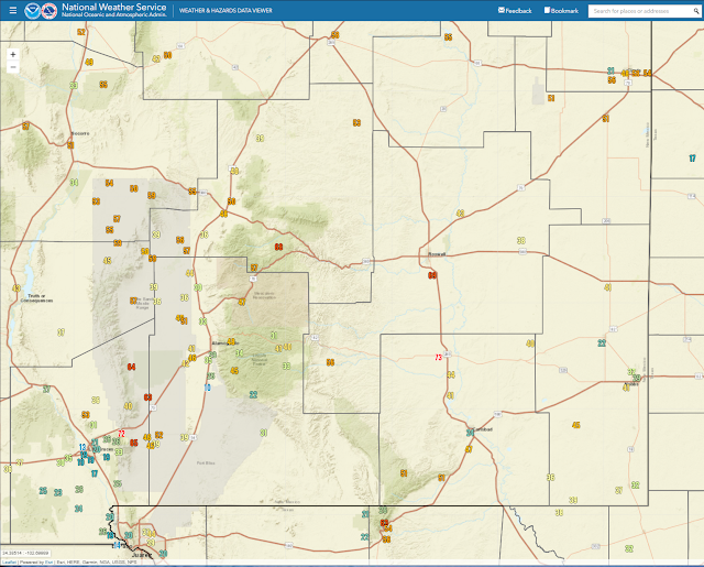
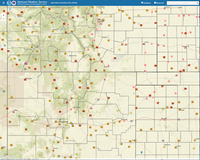
New Mexico Reported Peak Wind Gusts.
NTSGUST 
• 8 SSW RED RIVER - 103 mph
• 6 NE LAS VEGAS - 90 mph
• 10 SSE MAGDALENA - 85 mph
• RATON CREWS AIRPORT - 84 mph
• LOS CERRILLOS - 81 mph
• 4 N AGUA FRIA - 77 mph
• 2 ENE CLAYTON - 76 mph
• 9 ENE TUCUMCARI - 76 mph
• 7 ENE TUCUMCARI - 74 mph
• 4 SSE ROSWELL - 69 mph
• 12 SSW EL VADO - 69 mph
• 2 SSW FORT STANTON - 68 mph
• 3 NE EDGEWOOD - 68 mph
• 1 SE LOS ALAMOS - 67 mph
• 4 WSW MILLS - 66 mph
• 12 S MONERO - 66 mph
• 5 E LOWER COLONIAS - 66 mph
• 3 S CAPULIN - 65 mph
• 6 WNW GLORIETA - 64 mph
• STANLEY - 63 mph
• 2 W FARMINGTON - 63 mph
• 12 N NAVAJO DAM - 63 mph
• 1 SSE CLINES CORNERS - 63 mph
• 5 S ARROYO HONDO - 62 mph
• 5 E TIJERAS - 62 mph
• 2 NNW ANGEL FIRE - 62 mph
• 2 SSW LOS ALAMOS - 62 mph
• 16 SSE EL MORRO - 61 mph
• 1 E SEDILLO - 61 mph
• 12 ENE BELL RANCH - 60 mph
• 10 S BINGHAM - 59 mph
• 6 NW EDGEWOOD - 59 mph
• 9 ESE MESITA - 59 mph
• 1 N RED HILL - 59 mph
• 3 ENE CLOVIS - 58 mph
• 3 WNW GALLUP - 58 mph
• 2 ESE SANTA ROSA - 58 mph
• 21 SE BOSQUE DEL APACHE REFUGE - 57 mph
• 5 WSW OSCURO - 57 mph
• 3 ENE MAGDALENA - 57 mph
• 2 NE DUNKEN - 56 mph
• 5 S ALBUQUERQUE - 56 mph
• 1 N CANNON AFB - 56 mph
• 3 NNE LA CIENEGA - 55 mph
• 1 NW SUMNER LAKE - 55 mph
• 16 SE CORONA - 55 mph
• 3 ESE MORIARTY - 55 mph
• 3 NNW TEXICO - 55 mph
• 15 NW CARRIZOZO - 55 mph
• BLOOMFIELD - 55 mph
• MAGDALENA - 54 mph
• 2 E STANLEY - 52 mph
• 2 SSW MILAN - 52 mph
• 1 W CONCHAS - 51 mph
• 13 SE TOLAR - 51 mph
• 4 NW ESPANOLA - 51 mph
• 6 NW ALBUQUERQUE - 50 mph
• 1 WNW LAS NUTRIAS - 49 mph
• 5 NNW FARMINGTON - 49 mph
• 22 SE BOSQUE DEL APACHE REFUGE - 48 mph
• NARBONA PASS - 46 mph
• 1 W MOUNTAINAIR - 46 mph
• 11 SE BOSQUE DEL APACHE REFUGE - 46 mph
• 2 S SOCORRO - 46 mph
• 9 SW CUBA - 45 mph
Last updated:
0451 PM 12/15/20
0451 PM 12/15/20
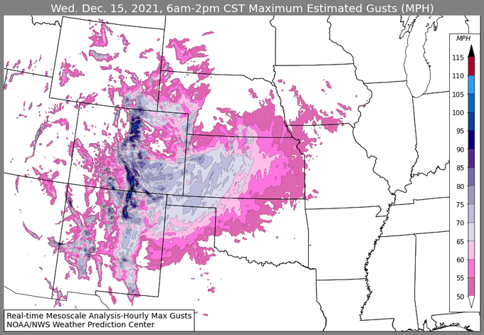
Here is a brief look at both the estimated and observed maximum wind gusts across the central U.S. for the 24 hour period ending 9 am CT. For a more detailed list, visit WPC's storm summary (wpc.ncep.noaa.gov/discussions/nf
). Local NWS forecast offices will have more information as well.
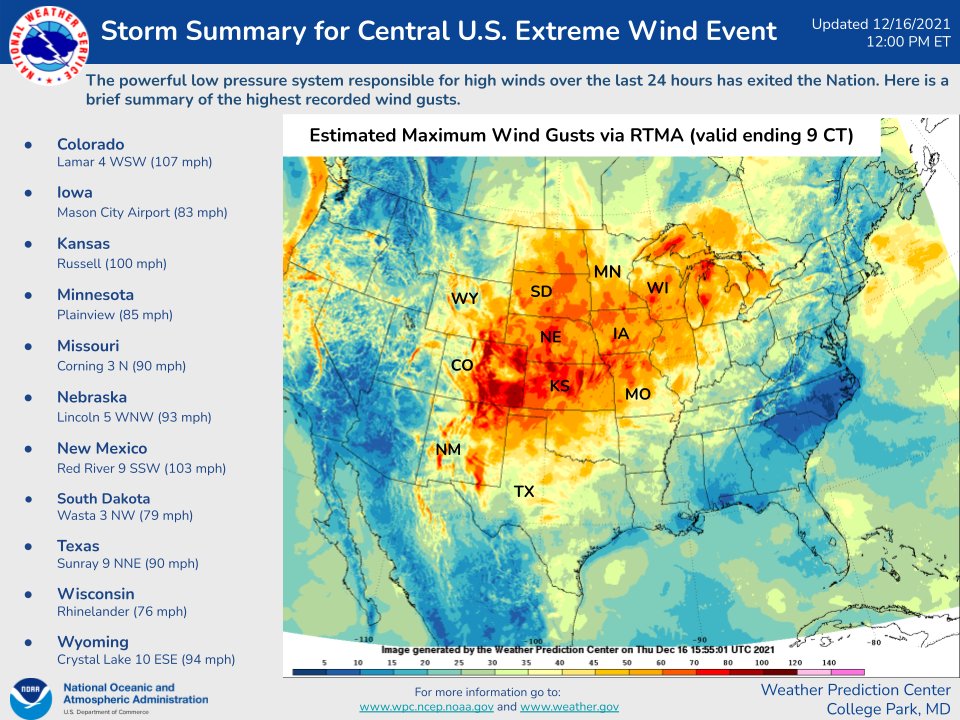
Wednesday's high wind event was one for the record books. Southwest to west wind gusts of 75 to 100 mph or higher were measured in New Mexico, the Texas and Oklahoma Panhandles, Colorado, Kansas, and Nebraska.
Locally the Artesia Airport clocked the strongest gust at 73 mph. While the Carlsbad Airport only peaked out at 41 mph. Even Guadalupe Pass didn't see the expected 70-90 mph gusts and only peaked out at 58 mph.
The reason for the much less strong wind gusts south of Artesia was due to the location of the jet stream. The core of the jet stream remained north of Carlsbad with the strongest winds aloft. So the best mixing of the strong winds aloft occurred north of the Carlsbad area. Tumbleweeds had a heyday as well. Blowing dust was bad from Artesia northward during the peak wind gusts.
The reason for the much less strong wind gusts south of Artesia was due to the location of the jet stream. The core of the jet stream remained north of Carlsbad with the strongest winds aloft. So the best mixing of the strong winds aloft occurred north of the Carlsbad area. Tumbleweeds had a heyday as well. Blowing dust was bad from Artesia northward during the peak wind gusts.
The Truth Is Stranger Than Fiction!


.png)


Comments
Post a Comment
Your comments, questions, and feedback on this post/web page are welcome.