


Our Next Fast Moving Winter Storm Will Be A Wind Bag.

White Pine Road.
Seven Rivers, NM.

Surface Map Forecast.

Our Next Fast Moving Winter Storm Will Be A Wind Bag.
Our local weather of late has been rather quiet and boring. A change to this tranquility will begin with tomorrows fast moving mid-upper level storm zipping across northern New Mexico. A second and stronger storm is forecast to affect the region late this weekend. A third around next Tuesday.
A fast moving Pacific cold front will race across the state on Wednesday behind the departing mid-upper level storm. Scattered lowland rain showers and mountain snows are forecast for the western and northern mountains of the state.
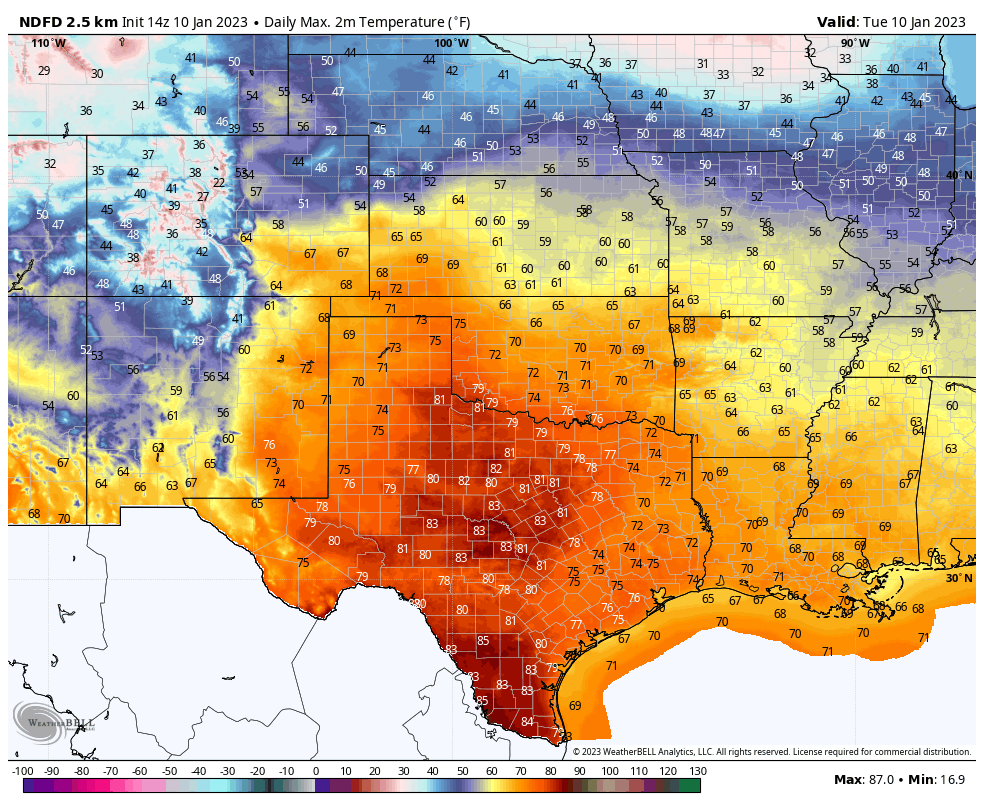
Near record to record warmth is forecast locally today ahead of our next winter storm. Our afternoon high temps across the southeastern plains and parts of West Texas are expected to top out today in the low 70's to near 80º range. A few local daily record high temps may be tied or broken. High temps today will be some 11º to 22º above normal. Our highs on Wednesday will be about ten degrees cooler. And our highs on Thursday will be close to normal with readings in the 50's.
High temps today across the Sacramento mountains are forecast to range from the low to mid 50's in the Sacramento/Weed/High Rolls/Mountain Park areas to the mid 60's in the Mayhill area, to the mid to upper 50's in the Ruidoso area, to the low to mid 40's in the Cloudcroft/Sunspot areas. These readings will be around 10º lower tomorrow and Thursday in the colder air mass behind the front.
As slow warming trend commences Friday into next weekend ahead of the next storm.
As slow warming trend commences Friday into next weekend ahead of the next storm.
NWS NDFD Forecast High Temp Anomalies Today.

NWS NDFD Forecast High Temperatures Wednesday.

NWS NDFD Forecast High Temp Anomalies Wednesday.

NWS NDFD Forecast High Temps Thursday.


Southeastern Plains.
Roswell Airport (ThreadEx Station) - (1893 - 2022) 78 in 1953
Caprock NWS Climate Co-Op Station (2007 - 2022) 77 in 2017.
Hope NWS Climate Co-Op Station (1905 - 2022) 76 in 2005.
Artesia NWS Climate Co-Op Station (1905 - 2022) 82 in 2017.
Carlsbad NWS Climate Co-Op Station (1900 - 2021) 80 in 1911.
Carlsbad Airport (1930 - 2022) 78 in 1953.
Carlsbad Caverns NWS Climate Co-Op Station (1935 - 2022) 79 in 2017.
Hobbs NWS Climate Co-Op Station (1913-2020) 73 in 1945.
Tatum NWS Climate Co-Op Station (1919 - 2016) 75 in 2005.
WIPP NWS Climate Co-Op Station (1886 -2022) 81 in 2017.
Jal NWS Climate Co-Op Station (1919 - 2022) 80 in 1953.
Sacramento Mountains.
Ruidoso NWS Climate Co-Op Station (1941 - 2022) 68 in 1990.
Picacho NWS Climate Co-Op Station 78 in 1990.
Picacho NWS Climate Co-Op Station 78 in 1990.
Cloudcroft NWS Climate Co-Op Station (1901 - 2022) 58 in 1990.
Elk NWS Climate Co-Op Station 79 in 1953.
Mountain Park NWS Climate Co-Op Station (1894 2022) 64 in 2005.
Alamogordo NWS Climate Co-Op Station (1892 - 2009) 76 in 1909.


High Winds/High Fire Danger/Localized Blowing Dust.
Once again this next inbound winter storm will swing across the northern areas of the state tomorrow. When this happens the southern and eastern areas of the state end up strong winds. This will be the case Wednesday.
Southwesterly to westerly winds will become sustained at around 30-40 mph with gusts near 50 mph (possibly higher in some areas) tomorrow across the Southeastern Plains. Additional Wind Advisories or High Wind Warnings may be required locally.
Southwesterly to westerly winds will become sustained at around 30-40 mph with gusts near 50 mph (possibly higher in some areas) tomorrow across the Southeastern Plains. Additional Wind Advisories or High Wind Warnings may be required locally.
A High Wind Watch remains in effect for the Guadalupe/Delaware/Davis mountains from Wednesday morning through Wednesday evening. West winds are forecast to increase to sustained speeds of 40-55 mph with gusts near 65-75 mph.
A High Wind Watch remains in effect for eastern Lincoln County and southwestern Chaves County from Wednesday morning through Wednesday afternoon. West winds are forecast to become sustained at 30-40 mph with gusts near 65 mph.
A High Wind Watch remains in effect for the southern Sacramento mountains from Wednesday morning through Wednesday afternoon. West winds are forecast to become sustained at 30-40 mph with gusts near 60 mph.
A Fire Weather Watch remains in effect for all of Southeastern New Mexico and most of West Texas on Wednesday. A Fire Weather Watch means that critical fire weather conditions are forecast to occur. Listen for later forecasts and possible Red Flag Warnings.
Localized areas of blowing dust will also occur associated with the stronger winds gusts and the frontal passage. As always this will be especially true over and near the following areas:
Open or freshly plowed farmland, fields, lots, and highway construction sites. Sudden drops in the visibility with little warning will occur in and near these areas.
Open or freshly plowed farmland, fields, lots, and highway construction sites. Sudden drops in the visibility with little warning will occur in and near these areas.

NWS NDFD Storm Total Precipitation Forecast.


Moderate to severe drought conditions still exist across the Southeastern Plains with abnormally dry conditions across the Sacramento, Capitan, and Guadalupe mountains. A pattern change still looks to occur after the middle of the month going into the end of the month. The jet stream is expected to start sending more storms our way down the road. The question is how wet will they be? And will they break the ongoing drought? For now the answer is no they will not at least locally. We will have to see what the last half of this winter season has to offer.
Always Check The Home Page For The Latest/Current Watch/Warning/Forecast Information.


Comments
Post a Comment
Your comments, questions, and feedback on this post/web page are welcome.