


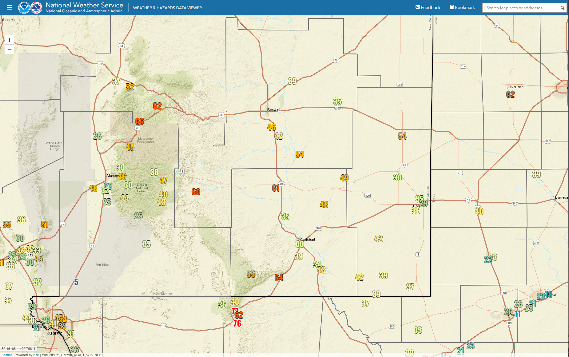
Storm Summary Peak Wind Gusts Reported Sunday - Monday, January 16, 2023.

Looking East On US Hwy 70.
Altocumulus Standing Lenticular Clouds (ACSL) West Of Roswell, NM.
Reported Peak Wind Gusts Sunday.
Bowl Raws located just N of Guadalupe Peak 77 mph.
Guadalupe Pass ASOS 76 mph.
3 Cross PWS NE of Elk & N of Dunken 71 mph.
Smokey Bear Raws located 1 mile NW of Ruidoso 66 mph.
Buck Mtn PWS Near Ski Apache 65 mph.
Bat Draw Raws - Carlsbad Caverns Visitor Center 64 mph.
Pine Springs Raws - Guadalupe Mtn's Natl Park 62 mph.
Sierra Blanca Regional Airport 62 mph.
Artesia Airport AWOS 61 mph.
Dunken Raws 60 mph.
Seven Rivers - KOA Campground PWS 60 mph.
Queen Raws 55 mph.
Mayes Ranch PWS - SW of Whites City 55 mph.
Tatum PWS 54 mph.
Hagerman NMC26 54 mph.
Mayhill PWS - W of Mayhill 52 mph.
Seven Rivers NMCC (Located 2 miles NE of Lakewood) 52 mph.


ublic Information Statement
National Weather Service El Paso TX/Santa Teresa NM
821 PM MST Sun Jan 15 2023

...HIGHEST WIND REPORTS...

Location                     Speed     Time/Date       Lat/Lon
WSMR Museum                  76 MPH    0945 AM 01/15   32.38N/106.48W
WSMR Building 1830           75 MPH    0910 AM 01/15   32.37N/106.47W
WSMR Main Post               70 MPH    0950 AM 01/15   32.37N/106.49W
San Agustin Pass 1.6 E Organ 70 MPH    0935 AM 01/15   32.43N/106.57W
Globe                        70 MPH    0905 AM 01/15   32.38N/106.47W
Condron Field (WSMR)         67 MPH    0955 AM 01/15   32.34N/106.41W
Biggs Field AWOS             66 MPH    1030 AM 01/15   31.85N/106.38W
South Franklin Peak          59 MPH    0145 PM 01/15   31.86N/106.49W
Chiricahua Desert Museum     55 MPH    0740 AM 01/15   31.87N/109.02W
El Paso International Airpor 55 MPH    1251 PM 01/15   31.82N/106.38W
Cdrrc Camp Location          55 MPH    1045 AM 01/15   32.58N/106.87W
WSMR EMRE                    55 MPH    0935 AM 01/15   32.47N/106.50W
El Paso NE - KB5HPT          54 MPH    0131 PM 01/15   31.92N/106.43W
WSMR Apache                  53 MPH    0955 AM 01/15   32.63N/106.39W
Mayhill - Dimension Point Ob 52 MPH    1130 AM 01/15   32.91N/105.53W
Brillo West                  52 MPH    0925 AM 01/15   32.96N/106.54W
Sierra Blanca (TTU/WTM)      51 MPH    0105 PM 01/15   31.16N/105.35W
Deming ASOS                  51 MPH    0252 PM 01/15   32.27N/107.72W
Las Cruces AWOS              51 MPH    1155 AM 01/15   32.27N/106.92W
Holloman AFB AWOS            48 MPH    1206 PM 01/15   32.85N/106.08W
Dell City (TTU/WTM)          46 MPH    0156 PM 01/15   31.95N/105.20W
High Rolls                   46 MPH    1029 AM 01/15   32.94N/105.84W
Hachita Valley               46 MPH    1040 AM 01/15   31.70N/108.34W
WSMR Pony                    46 MPH    0615 AM 01/15   32.87N/106.49W
Dripping Springs RAWS        45 MPH    0126 PM 01/15   32.32N/106.59W
Mayhill RAWS                 45 MPH    0101 PM 01/15   32.91N/105.47W
Mescalero RAWS               45 MPH    0941 AM 01/15   33.16N/105.77W
Santa Teresa NWS RSOIS       45 MPH    1229 PM 01/15   31.87N/106.70W
Las Cruces                   44 MPH    1215 PM 01/15   32.36N/106.72W
Santa Teresa AWOS            44 MPH    1135 AM 01/15   31.88N/106.70W
South Radium Springs         44 MPH    0210 PM 01/15   32.48N/106.90W
San Andres RAWS              44 MPH    0401 PM 01/15   32.58N/106.53W
T-or-C ASOS                  43 MPH    0217 PM 01/15   33.23N/107.27W
Organ (DACFC)                43 MPH    1213 PM 01/15   32.42N/106.60W
Las Cruces - Las Colinas     42 MPH    1218 PM 01/15   32.38N/106.74W
Dona Ana County Fairgrounds  42 MPH    1232 PM 01/15   32.26N/106.97W
Las Cruces - Tierra Grande ( 42 MPH    1230 PM 01/15   32.39N/106.67W
T Or C Golf Course           42 MPH    0155 PM 01/15   33.15N/107.26W
WSMR LC-32                   42 MPH    0910 AM 01/15   32.41N/106.40W
Butterfield Trail Ranch      41 MPH    0159 PM 01/15   32.26N/107.24W
Las Cruces - S Fork LC Arroy 41 MPH    1245 PM 01/15   32.34N/106.71W
Lordsburg Playa I10 MP7 (NMD 41 MPH    1000 AM 01/15   32.25N/108.93W
Lordsburg Playa I10 MP9 (NMD 41 MPH    1250 PM 01/15   32.27N/108.90W
North Lordsburg Playa        41 MPH    1000 AM 01/15   32.25N/108.95W
Lincoln Portable             41 MPH    0230 PM 01/15   32.75N/105.49W
WSMR C-Station               41 MPH    0955 AM 01/15   32.36N/106.38W
Weed - Dark Ridge Obs        40 MPH    0150 PM 01/15   32.80N/105.47W
Burro Mountain RAWS          40 MPH    0859 AM 01/15   32.67N/108.54W
Lordsburg Playa I10 MP12 (NM 40 MPH    1250 PM 01/15   32.29N/108.87W

Observations are collected from a variety of sources with varying
equipment and exposures. We thank all volunteer weather observers
for their dedication. Not all data listed are considered official.
Always Check The Home Page For The Latest/Current Watch/Warning/Forecast Information.


Comments
Post a Comment
Your comments, questions, and feedback on this post/web page are welcome.