

Line Up The Winter Storms!

Mayhill, New Mexico.

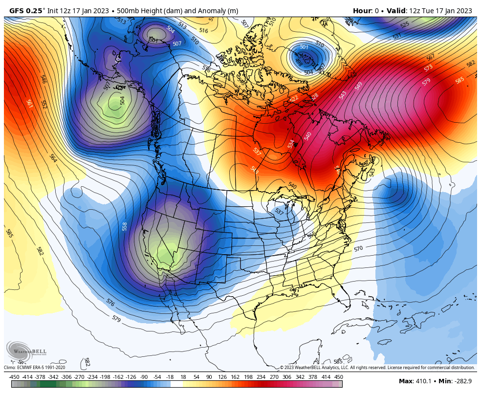
GFS 500 MB Forecasts.


Storm after storm will be our weather theme for awhile. La Nina is dying and we are beginning to enter a neutral phase. The question is how long will we remain in the neutral phase before we transition into El Nino conditions...hopefully by this fall and next winter.
Anyway whenever the atmosphere undergoes a major pattern shift things get chaotic and crazy. We see this every year with seasonal changes and this current shift out of La Nina conditions will likely be stormy and unsettled into the spring. Computer forecast model mayhem rules as they struggle with the complicated and changing upper air pattern.


Local Two Day Snowfall Totals.
As of 8 AM MST this morning the Cloudcroft National Weather Service Climate Co-Op Station recorded a two day snowfall total of 3.9". This brings their January total to 4.0" and their seasonal total (Oct 1, 2022 - Jan 17, 2023) to 32.6" Normal to date total for them is 33.5"
Compare this with the El Nino winter of 1957 and 1958. Officially Cloudcroft recorded 180.0" of snow for that season (Oct 1, 1957 - April 30, 1958). This total is second only to the 1914-1915 season with 180.1". Incredibly their snowiest month on record for all available station locations (1901 - 2023) was 82.0" in March, 1958.
Compare this with the El Nino winter of 1957 and 1958. Officially Cloudcroft recorded 180.0" of snow for that season (Oct 1, 1957 - April 30, 1958). This total is second only to the 1914-1915 season with 180.1". Incredibly their snowiest month on record for all available station locations (1901 - 2023) was 82.0" in March, 1958.

(Oct 1, 2022 - Jan 16, 2023).

Local Two Day Snowfall Totals.

Lincoln County Seasonal Snowfall Totals.
(Oct 1, 2022 - Jan 16, 2023).

More Snow Today.
Winter Weather Advisories remain in effect for the southern and northern Sacramento mountains until midnight tonight.
Additional snowfall totals of 3" to 7" are forecast for the Cloudcroft area today above 7,500'. Gusty westerly winds between 30-40 mph will produce localized areas of blowing snow and wind chill temperatures as low as 8º today and -3º tonight.
Additional snowfall totals of 3" to 7" are forecast for the Cloudcroft area today above 7,500'. Gusty westerly winds between 30-40 mph will produce localized areas of blowing snow and wind chill temperatures as low as 8º today and -3º tonight.
Additional snowfall totals of 2" to 4" are forecast in the Ruidoso area today. Gusty westerly winds up to around 45 mph will create areas of blowing snow.
Additional snowfall totals of 9" to 13" are forecast for Ski Apache today. Westerly winds gusting up to around 55 mph today will create areas of blowing snow. Wind chill values today into Wednesday night will drop down to around -2º.
Today's winter storm will exit stage right and leave New Mexico by tomorrow morning. A Pacific cold front will move eastward across the state and clear southeast New Mexico tonight. Another winter storm is set to impact the local area and state Friday into the weekend. And a third potentially colder and stronger storm is due the first of next week.
An isolated thunderstorm or two will be possible today across the northeastern and eastern plains of the state. Wintertime thunderstorms are not unheard of in New Mexico. When they are accompanied by snow (thundersnow) they are really fun to experience.
Widely scattered rain showers are possible today across the Southeastern Plains but rainfall totals are forecast to stay below a tenth of an inch.
Our second winter storm due to impact the region Friday into the weekend may produce a wintry mix across the Southeastern Plains Friday night into Saturday.
This third storm may be strong and cold enough to produce snow at the lower elevations such as the El Paso area and the souther desert areas of New Mexico. As well as across the Southeastern Plains.


High Winds & Blowing Dust For SE NM & W TX Wednesday.
Bowl Raws N of Guadalupe Peak 77 mph.
Guadalupe Pass ASOS 75 mph.
Pine Springs W Tx Mesnet Station 67 mph.
Pinery Raws - Pine Springs 56 mph.
Carlsbad Airport ASOS 55 mph.
Lincoln Portable Raws - S of Weed 50 mph.
Lincoln Portable Raws - S of Weed 50 mph.
Yet another high wind and blowing dust event is forecast for the Southeastern Plains and parts of West Texas tomorrow.
West winds sustained at around 30 to 45 mph with gusts around 65 mph are possible Wednesday in Eddy County. A High Wind Watch remains in effect on Wednesday.
West winds sustained at around 30 to 45 mph with gusts around 65 mph are possible Wednesday in Eddy County. A High Wind Watch remains in effect on Wednesday.
West winds sustained at around 45 to 60 mph with gusts near 80 mph are forecast for the Guadalupe mountains of Eddy County, and Culberson County in West Texas, including the Guadalupe Pass area. A High Wind Watch remains in effect for these areas on Wednesday.
These watches may be upgraded to warnings later today or Wednesday morning and additional High Wind Watches/Warnings and or Wind Advisories may also be issued for the local area so keep abreast of your local forecasts. Dangerous cross winds on north/south facing highways may make travel difficult to dangerous in some of these areas.
Blowing dust may become widespread on Wednesday with significant drops in the visibility possible across the Southeastern Plains and nearby areas. Sudden drops in the visibility down to near zero may occur during the strongest gusts especially over and near the following locations:
Freshly plowed, exposed, or open farmlands, fields, and lots. As well as highway construction sites and other dust prone locations.


8-14 Day Long-Range Temperature Outlook.

10-Day Precipitation Outlook.

8-14 Day Precipitation Outlook.


Comments
Post a Comment
Your comments, questions, and feedback on this post/web page are welcome.