


Significant Ice Storm For SE NM & West Texas?

Vaughn, New Mexico.
Snow drifts and patches still left over from a storm that across the area a week ago. These snow fences in the Vaughn area have been up for as long as I can remember. And that's at least fifty years. They were erected to help reduce the deep snow drifting that occurs in this area along the north-south orientated US Hwy 285. Strong westerly winds occurring after a storm create huge drifts that sometimes blocks traffic.

European (ECMWF) 500 MB (18,000' MSL) Forecasts.


Valid At 5 AM MST Wednesday Morning.


Surface Map Forecast.


If you think that is cold here in Southeastern New Mexico and West Texas then take a look at the temperatures to our north. Single digit temperatures cover all of the eastern plains of Colorado. Teens are noted in far northeastern New Mexico and the Texas Panhandle. While the Southeastern Plains temps have risen to 32º, most of West Texas is still in the low to mid twenties. Areas of freezing fog with pockets of mist, freezing drizzle have us socked in east of the mountains. A few breaks in the clouds are showing up but these will quickly fill back in tonight.
This arctic air mass is very shallow and only a couple of thousand feet deep. At 4 PM MST the temperature at the Mayhill was 55º and 51º in Ruidoso, while it was was 30º in Artesia. In far northeastern New Mexico Clayton was 12º.
Peter Sinks, Utah cratered to a bone numbing -62ºF for a low temperature this morning. Exactly 21 years ago on this date they also recorded a low of -62ºF on January 30, 2002.
Significant Ice Storm Shaping Up.

European (ECMWF) Sleet Accumulation Forecast.
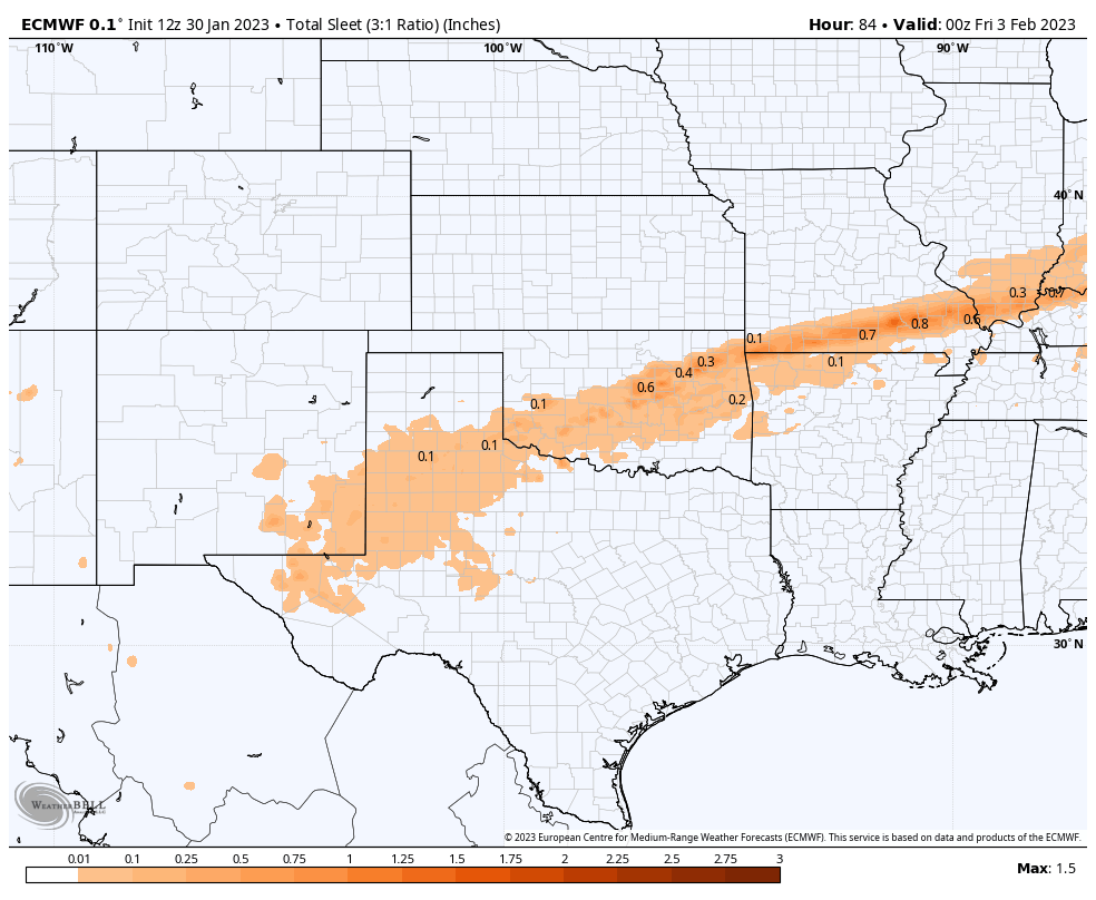
Valid Today Through 5 PM MST Thursday.

Valid Today Through 5 PM MST Thursday.
(As Of 3:30 PM MST Monday Afternoon).


Significant Ice Storm For SE NM & West Texas!
Another powerful and complicated winter storm is already making life miserable for a lot of us east of the mountains today. Arctic air is locked in and isn't going anywhere anytime soon. As you may have guessed the computer forecast models once again are struggling with this set up. Bottom line is that conditions go down hill tonight into at least Thursday morning with the worst of the ice storm expected to occur Tuesday night into Thursday morning.The models are struggling with the temperature, precipitation type, precipitation amounts, and coverage. So like a broken record this winter expect to see changes with some of our local forecasts.
A deep and cold closed mid/upper-level low is forecast to very slowly move southeastward from near Los Angeles, California today to the northern Baja Region by Wednesday morning. Then slide eastward south of the US and Mexico border Wednesday into Thursday before turning northeast and ejecting out of our local area by Thursday night. How fast it moves out of the area or how long it remains to our southwest will have huge impacts upon our local forecasts.
A Winter Weather Advisory is in effect for Eddy, Lea, and Culberson Counties and parts of West Texas from 11 PM MST tonight through 11 AM MST Wednesday. A Winter Storm Warning is in effect further east across Texas. Ice may damage trees and bring down power lines and other utility lines in areas of West Texas covered in the Winter Storm Warning.
Another round of freezing fog, light freezing drizzle, and or light freezing rain is forecast tonight into Tuesday. Light icing with glaze is expected on exposed surfaces, roadways, bridges and overpasses. A more significant threat for freezing fog, freezing drizzle and freezing rain will exist Tuesday night into Wednesday night. Sleet may mix in with the freezing drizzle and freezing rain off and on at times Tuesday night through Thursday. Current forecasts call for ice accumulations across Eddy and Lea Counties of a tenth of an inch or less. However this may change with heavier accumulations possible.
Another round of freezing fog, light freezing drizzle, and or light freezing rain is forecast tonight into Tuesday. Light icing with glaze is expected on exposed surfaces, roadways, bridges and overpasses. A more significant threat for freezing fog, freezing drizzle and freezing rain will exist Tuesday night into Wednesday night. Sleet may mix in with the freezing drizzle and freezing rain off and on at times Tuesday night through Thursday. Current forecasts call for ice accumulations across Eddy and Lea Counties of a tenth of an inch or less. However this may change with heavier accumulations possible.
Travel upon our local roads and highways may be impacted once again (as was this morning in some areas) by the ice and freezing fog. More so in West Texas to our east. More widespread and significant travel issues may develop Tuesday night into Thursday morning. Check the New Mexico Roads (800-432-4269) and Texas Drive (800-452-9292) web pages for the latest road conditions.
A rain and snow mix is currently forecast over the Sacramento and Capitan mountains Wednesday into Thursday. As of this writing no significant impacts are forecast but I suspect this could also change.
The European model spreads light to moderate snow across the Southeastern Plains Wednesday afternoon through Thursday afternoon. While parts of West Texas (the eastern Permian Basin eastward and northeastward) more experience a major ice storm Tuesday night into Wednesday night. I'll update as needed and more info on the storms exact track, speed, and impacts becomes available.
There Are None So Blind As Those Who "Will - Not" To See...107.


Comments
Post a Comment
Your comments, questions, and feedback on this post/web page are welcome.