


Very Strong Winter Storm/Widespread Snow - Some Heavy Tonight Into Tuesday.

Near Sunspot South Of Cloudcroft, NM.

At 1:06 PM MST This Monday Afternoon.
Water Vapor Satellite Image.
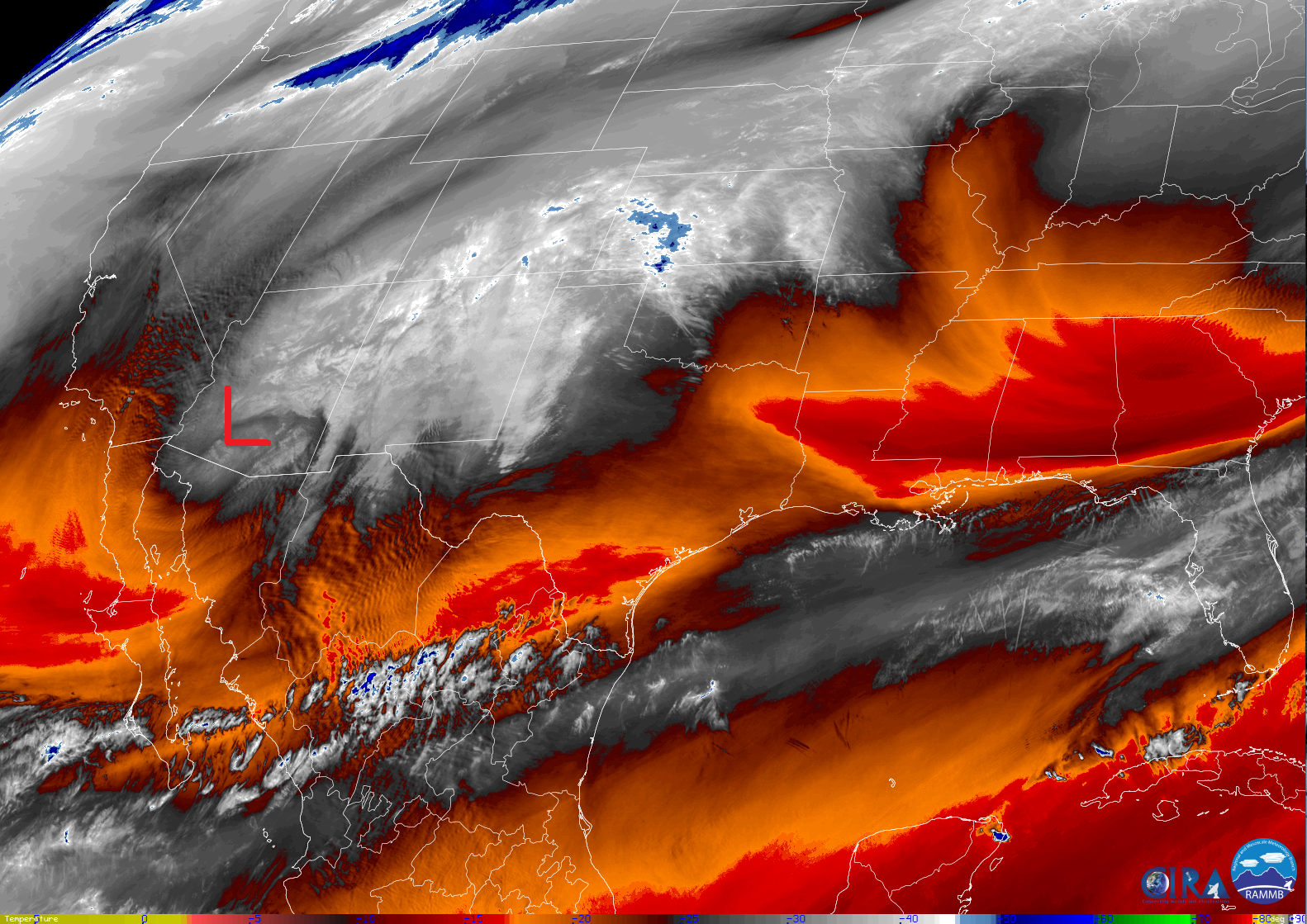

Very Strong Winter Storm Continues Digging South Through Arizona.
An intense closed mid/upper-level low was centered over south-central Arizona this afternoon. As per the Phoenix, Arizona NWS AFD the strength of this storm is near record levels. Looking at the visible and water vapor satellite images above it is easy to pick out the location of this low.
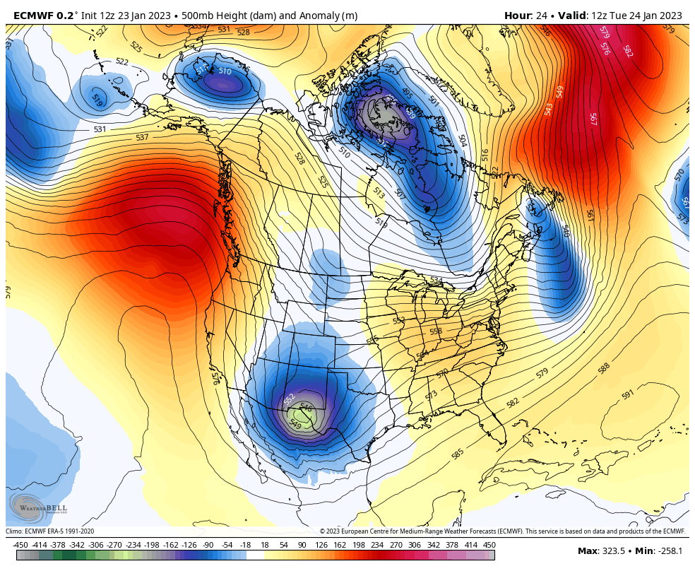
Latest forecast model outputs track the mid/upper-level closed low southeastward tonight sliding south of Tucson, AZ around sunset this evening. By sunrise it should be just south of El Paso. How fast the storm then pulls off to the northeast and east will help determine storm total snowfall amounts for the area. If slower than forecast...more snow for some. If faster than forecast...less snow for some.
Lots of Winter Storm Warnings & Winter Weather Advisories Now In Effect.

Surface Map Forecast.

(Tonight Into Tuesday Morning).

Thunderstorms Late Tonight Into Tuesday Morning.
Low level easterly and southeasterly upslope flow from the Gulf of Mexico will increase tonight as the low-level jet strengthens and advects moisture into the area. As this happens the atmosphere will become unstable enough to support widely scattered thunderstorms across parts of Southeastern New Mexico and West Texas. These will be elevated in nature and will be capable of producing locally heavy rainfall and possibly some localized flash flooding. Mainly across the Permian Basin.
As the intense mid/upper-level closed low to our west approaches late tonight into Tuesday morning the atmosphere will destabilize aiding in the thunderstorm development. Thundersnow will be possible across the area late tonight into early Tuesday morning as rain changes over to snow. Periods of sleet may also occur in some locals which experience a thunderstorm.
At the surface a strong surface low has formed over southwestern New Mexico west of El Paso this afternoon. Southwesterly to westerly winds have already gusted up into the 40+ mph range near this low and it's associated Pacific cold front. East canyon winds have gusted up to near 60 mph today in the Albuquerque Metro area. This front will enter southeastern New Mexico late tonight into early Tuesday morning. Southeasterly winds have gusted up into the 40+ mph range across parts of Eddy and Lea Counties today, and parts of West Texas. These winds will continue tonight shifting around to the west after the frontal passage. Northwest winds sustained at around 15-25 mph will gust up to around 30-40 mph.
Winter Storm Warnings & Winter Weather Advisories.


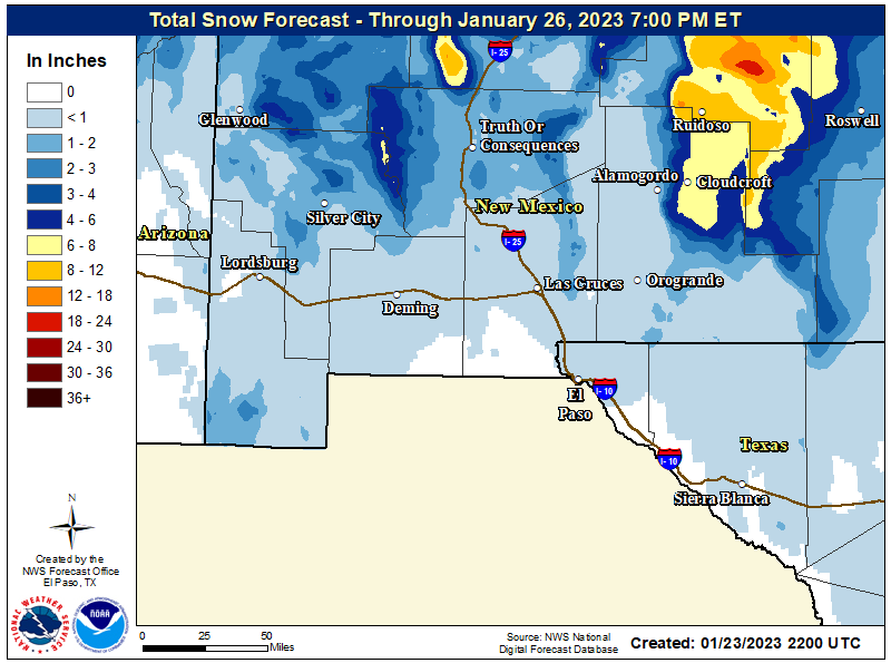


Most of New Mexico and West Texas are under Winter Storm Warnings or Winter Weather Advisories for late this afternoon through Tuesday. Snowfall is forecast to be the heaviest over the Sacramento, Capitan, and Guadalupe Mountains. Snow has started falling in Ruidoso as of 3:45 PM MST with moderate snow falling at Ski Apache.
Current forecast storm total snowfall amounts as of 3:00 PM MST are listed below:
Lower elevations of Lincoln County - 3" to 6" with 6" to 10" in eastern Lincoln County including the Ruidoso area. With 6" to 10" and locally up to 16" in the higher elevations of the northern Sacramento and Capitan Mountains.
Chaves County Plains - Including the Roswell area. 1" to 4". Southwestern Chaves County- 6" to 10" in the Elk area.
Eddy County Plains - Including the Artesia and Carlsbad areas...up to 4".
Guadalupe Mountains of Eddy County - Including the Queen area up to 6" possibly higher.
Lea County - Including the Tatum, Hobbs, and Jal areas. Up to 4" in the Tatum area and 2" in the Hobbs area. Less than an inch in the Jal area.
Otero County/Southern Sacramento Mountains - Including the Sunspot, Cloudcroft, High Rolls/Mountain Park, Apache Summit, Silver Lake, 16 Springs Canyon/Wimsatt, Mayhill, Sacramento/Weed, Pinon, and Timberon areas 6" to 8" with up to 12" possible above 9,000'.
Otero County - Including the Tularosa Basin and the Alamogordo areas 1" to 2".
Otero County - Including the Tularosa Basin and the Alamogordo areas 1" to 2".
Given how deep the mid/upper-level low is I strongly suspect that some areas may end up with a lot more snow than what current forecast models are spitting out. This will be especially true in those locations that experience mesoscale convective banding, underneath the trowel, and during thundersnow bursts.
Travel will become difficult and dangerous in many areas tonight into Tuesday especially across the mountains, and parts of the Eastern and Southeastern Plains. I suspect that we will see some road closures during this event. Areas of blowing and drifting snow will aggravate these conditions.
If the snow is wet and heavy enough we may also see some power lines and tree limbs come down underneath the weight of the heavy snow. Current forecasts call for the winter storm to pull northeastward out of the local area by Tuesday night. Be alert for changing weather conditions and changing local forecasts.
There Are None So Blind As Those Who "Will - Not" To See...107.


Comments
Post a Comment
Your comments, questions, and feedback on this post/web page are welcome.