Fall Weather Is On The Way.
Fall Weather Is On The Way.
European (ECMWF) 500 Millibar (18,000' MSL) Forecast.
European (ECMWF) 500 Millibar (18,000' MSL) Forecast.
Valid At 6 PM MDT Tuesday, Oct 24, 2023.
Remnant Moisture From Former Hurricane Norma Mostly Misses Us.
Remnant Moisture From Former Hurricane Norma Mostly Misses Us.
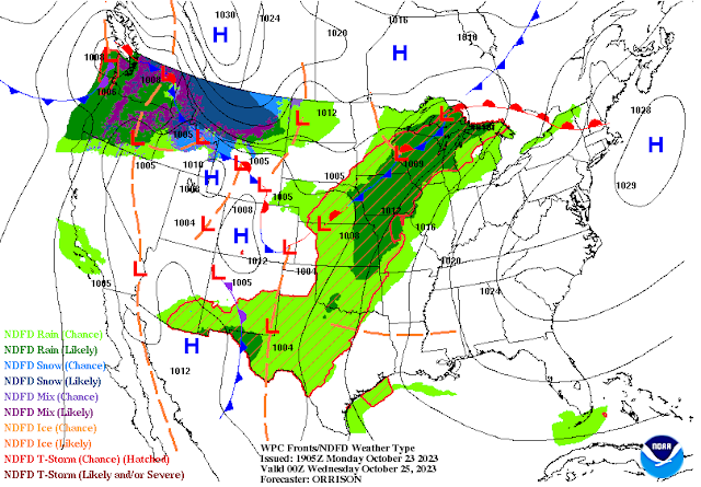
A strong mid-upper level closed low was dropping southward through southern California this afternoon. It will continue to drop south and into northwestern Mexico by around sunset Tuesday evening. Then it slides slowly eastward to near El Paso by noontime Wednesday. After that it lifts northeastward into central Kansas and basically washes out on Thursday.
A Pacific cold front is forecast to slide eastward to a Socorro-Las Cruces-east of El Paso line by sunset Tuesday.
Remnant moisture from former Hurricane Norma that moved inland near the southern tip of Baja, California two days ago is streaming overhead. Radar shows scattered rain showers and a few thunderstorms over far eastern and southeastern Lea County as of 3:30 PM MDT this Monday afternoon. This activity is more widespread and heavier in parts of West Texas.
For all intent and purposes the majority of this tropical moisture will have a limited effect on Southeastern New Mexico's weather. Our chances for measurable rainfall tonight ranges from 20% tonight into Tuesday for the Roswell, Artesia, Carlsbad areas. The Hobbs area has a 30% to 40% of getting wet through Tuesday.
Weather Prediction (WPC) Storm Total Rainfall Forecast.
National Blend Of Models (NBM) Storm Total Rainfall Forecast.
Scattered T-Storms Tuesday - Some Severe!
As the closed mid-upper level low approaches from the southwest Tuesday afternoon and evening scattered thunderstorms are forecast to develop across southern, south-central, southeastern, and parts of eastern New Mexico, as well as parts of West Texas. A few of these will become severe and produce large hail and damaging thunderstorm wind gusts.
Locally heavy rainfall will also produce localized flash flooding.
Our chances for measurable rainfall jump up into the 50% range Tuesday night into Wednesday across the southeastern plains.
Across the Sacramento and Capitan mountains the chances for measurable rainfall increase into the 30%-60% range Tuesday into Wednesday. With highs this week in the 50's for the Cloudcroft area, and the 60's for the Ruidoso area.
Tuesday night into Wednesday the Ski Apache NWS forecast calls for a mix of rain and snow showers with a few thunderstorms mixed in. It is possible that in the Cloudcroft area generally above the 9,000' level you could see a mix of rain and snow briefly Tuesday night.
Our high temps will be in the 70's Tuesday and Wednesday warming back up into the low to mid 80's Friday and Saturday. A strong backdoor cold front is forecast to dive southward down the eastern plains Saturday night and Sunday. The models aren't in total agreement on how cold the airmass will be behind this next front, but the first of next week potentially could only see highs in the 40's and 50's across the southeastern plains.
This morning's run of the Canadian forecast model (GEM) really goes far out on a limb and produces a high temp in Roswell of only 24F on Thursday, Nov 2nd. Yeah that might be a bit of a stretch, and that's way beyond any reasonable time frame to try and say that this is accurate. But you get the idea...colder temps with our first frost/freeze is not that far away so get ready. Typically we see our first freeze by around Halloween.
There Are None So Blind As Those Who "Will - Not" To See...107.


Comments
Post a Comment
Your comments, questions, and feedback on this post/web page are welcome.