Windy & Dusty Friday - Colder This Weekend.
Atoka - 6 Miles South Of Artesia, NM.
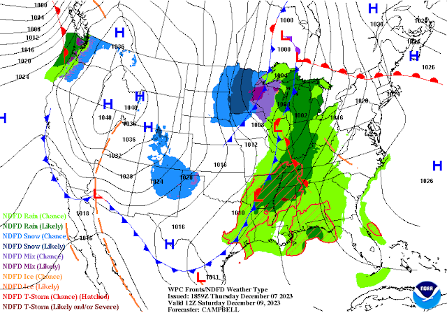
Surface Map Forecast.
Surface Map Forecast.
At 3 PM MST Thursday.
NWS NDFD Forecast High Temperature & Anomalies Thursday.
NWS NDFD Forecast High Temperature & Anomalies Friday.
A cold front will surge southeastward out of the Great Basin and into northern New Mexico by noontime on Friday. It will then plow rapidly southward through the reminder of the state before sunrise Saturday.
After seeing daytime high temps some 10 to 20-degrees above normal today, highs across southeastern New Mexico will be close to today's readings. Highs on Saturday's across the local area will be cooler with highs in the mid 40's to near 50.
Highs in the Sacramento mountains on Saturday will range from the upper 20's to the mid 30's.
Lows Sunday morning will be some of the coldest we've seen this season. In southeastern New Mexico we will see the upper teens to near 20.
In the Sacramento mountains lows Sunday morning will range from near 10 to the mid teens. A few of the normally colder mountain valleys will likely drop down into the single digits.
Lows across much of western and northern New Mexico will be in the 0 to 15-degree range. With the normally colder mountain valley's dropping down as low as 10 below zero.
GFS 500 MB (18,000' MSL) Forecast.
Our next winter storm was developing over the Pacific Northwest Coast west of Seattle and Portland at noon today. It will continue strengthening and diving to the southeast and by Friday around noontime it will be centered over the Great Basin. And by noontime Saturday a strong shortwave trough of low pressure will be pivoting eastward across northeastern and eastern New Mexico.
As the core of this next storm passes north of southeastern New Mexico so that means a windy and dusty day ahead on Friday. Strong mid-level winds aloft combined with strong dry downsloping southwesterly and westerly winds will combine to make for a warm, windy, and dusty day on Friday.
Wind Advisories are in effect for parts of the northern and central mountains, the northeastern and eastern plains. West winds are forecast to become sustained at around 25 to 35 mph with gusts in the 50-55 mph range.
Wind Advisories are in effect for parts of southeastern New Mexico (Eddy County) as well as parts of West Texas on Friday. Westerly winds are forecast to become sustained at 30 to 40 mph with gusts near 50 mph.
Wind Advisories are also in effect on Friday for parts of southern New Mexico (Otero County) and southwestern New Mexico. Westerly winds are forecast to become sustained at 25 to 35 mph with gusts near 55 mph.
A High Wind Warning remains in effect for the Guadalupe mountains of Eddy County and Culberson County through 9 PM MST Friday evening. Westerly winds are forecast to become sustained at around 40 to 50 mph with gusts near 75 mph.
There is the chance that additional Wind Advisories and or High Wind Warnings may be issued for parts of the area on Friday. Depending upon the exact track of the storm. So check you local forecasts often for any updates that may be issued by our local National Weather Service Offices.
Areas of blowing dust will also be possible Friday in the Warning and Advisories areas. Sudden drops in the visibility down to near zero will be possible in some normally dust prone locations such as: Freshly plowed, cultivated, or exposed farm lands, fields, lots, and highway construction sites. Local travel may be impacted in some of these areas so be alert for this if traveling in these affected areas.
This quick hitting winter storm will produce some snowfall across parts of the northern mountains, northeastern, and eastern plains. As of this writing (4:15 PM MST) only light amounts are forecast in these areas. Blowing snow may also occur in some of the heavier snow showers across northeastern New Mexico, especially in the Raton Pass area.
Snow is not currently forecast for the Sacramento mountains. A stronger, colder, and further south winter storm may bring winter weather back to the state next week.
There Are None So Blind As Those Who "Will - Not" To See...107.


Comments
Post a Comment
Your comments, questions, and feedback on this post/web page are welcome.