

T-Storms - Heat - Wind For This Memorial Day Holiday Weekend.
Blog updated at 8:20 PM MDT.

Severe T-Storm Watch #301 Was Issued For NE/E/SE NM
And W TX This Afternoon & Evening. At 8:05 PM MDT
A Line Of T-Storms Stretched Across SE NM. These
T-Storms Were Moving Northeastward At Around
25 MPH.


Today's Severe T-Storm Risk Area.

Today's Damaging Wind & Hail Risk Area.
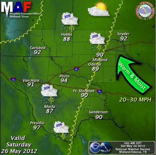
Scattered thunderstorms are forecast to develop along and east of the dryline across southeastern New Mexico and parts of west Texas this afternoon and evening. Most of us have a 20% - 30% chance of seeing measurable rainfall by tonight.
Some of these may become severe and produce large hail, damaging thunderstorm wind gusts in excess of 60 mph, and frequent deadly cloud to ground lightning.
Some of these thunderstorms may develop into Low Precipitating (LP) Supercells this afternoon and early evening across parts of southeastern New Mexico and west Texas. An isolated tornado or two will be possible with any of these LP Supercell thunderstorms.
At this time (10:50 AM MDT) Skywarn Spotter Activation is not currently anticipated across the Midland NWS County Warning Area. However, this could change by this afternoon. All Midland NWS Skywarn Storm Spotters are asked to remain alert to this potential, as well as the possibility of Spotter Activation across parts of the area later today.
A dry Pacific cold front will swing eastward across the state tomorrow. This will sweep the low-level moisture eastward out of southeastern New Mexico by tomorrow afternoon. Southerly winds will gust up to around 30 - 40 mph across the local area this afternoon. These winds will become southwesterly on Sunday and will once again gust up to around 30 - 40 mph.
Our high temperatures this afternoon will range from near 90 to the mid 90's. Similar temperatures are forecast for Sunday. Memorial Day will see afternoon highs in the low 90's. As a ridge of high pressure builds over the area by Tuesday, our afternoon highs will once again climb back up into the upper 90's to near 100.
The Truth Is Stranger Than Fiction!
My Web Page Is Best Viewed With Google Chrome.


Comments
Post a Comment
Your comments, questions, and feedback on this post/web page are welcome.