Badly Needed Rainfall On Its Way!
Click On The Maps To Enlarge Them.
Much Cooler Temperatures.
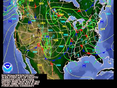
A strong cold front moved southward through the local area overnight. A much cooler airmass is spreading southward across southeastern New Mexico behind the front. Low clouds (stratocumulus) clouds generally between 1,200' and 3,000' AGL) are rapidly filling in behind the front as well. This is an indication of the low-level northeasterly-easterly upslope flow setting up across the area.
Most of us will only see high temperatures today in the 70's, there may be a few 80-degree readings this afternoon in the very southern areas. The Clovis and Portales areas are only forecast to be in the 60's today, so some of our northern areas across southeastern New Mexico may end up being a little cooler than forecast, especially if the low clouds do not burn off this afternoon.
Much cooler temperatures will occur tomorrow with most of southeastern New Mexico struggling to get out of the 60's. Overcast skies with scattered rain showers and thunderstorms are expected throughout most of the day tomorrow. This mornings National Weather Service forecasts keep us in the 70's throughout the rest of the work week. Welcome relief from the 95-100 degree temperatures we have been experiencing of late.
Increasing Chances For Rain Showers & Thunderstorms.
A mid-upper level disturbance is in the process of forming a cutoff low over northwestern Arizona this morning. This feature is forecast to drift southward into the Baja Region, and then eventually eastward towards New Mexico later this week. It will be a slow moving storm which will keep the chances of thunderstorms ongoing across the area this week.
As this mid-upper level storm to our west kicks out disturbances (shortwaves) from time to time this week, scattered rain showers and thunderstorms will break out over the area. The first round of thunderstorms is expected this afternoon across southeastern New Mexico. These thunderstorms are forecast to increase in aerial coverage by tonight. Some of these storms could last well into the night. Its possible that a cluster of thunderstorms, or a mesoscale convective complex (MCS) forms over southeastern New Mexico tonight, and then moves slowly into west Texas by tomorrow morning.
These slow moving thunderstorms are forecast to produce locally heavy amounts of rainfall across a wide swath of the area today into tomorrow. It appears that many of us could see storm total rainfall amounts of 1" - 2" with isolated pockets of higher totals when it is all said and done by the end of this week.
Flash Flood Potential Will Increase This Week!
Given that the area has been plagued by a historic drought for the past two years, and the fact that the ground is hard packed and some cases bare of vegetation, especially over the burn scar areas from last years fires, localized flash flooding will be a possibility this week. Southeastern New Mexico and nearby areas of west Texas is chocked full of normally dry arroyo's. These normally dry arroyo's can turn deadly in a heartbeat when they flood, especially at night.
If you should happen to drive upon one of these arroyo's that is flooded...please do not try and drive across them. You will not know if the roadway has been washed out beneath them or not, nor will you be able to tell accurately how deep the water is, especially at night. It only takes about a foot of fast flowing water to sweep a vehicle away. Remember to- Turn Around, Don't Drown! Please do not let your children play near or in these flooded arroyos either.
Some Thunderstorm May Become Severe Today Into Tomorrow.
There will be a risk of severe thunderstorms across the area today into tomorrow, and at times as well for the rest of the work week. Much will depend upon whether or not our skies can clear enough this afternoon for the atmosphere to destabilize sufficiently enough to severe thunderstorms, and how far south the frontal boundary will push.
There is the possibility of a few supercell thunderstorms across the area, especially this afternoon into tonight. At this time, large hail and damaging thunderstorm wind gusts appear to be the greatest severe weather threats, along with deadly cloud to ground lightning strikes, and localized heavy rainfall that may produce flash flooding. Please remember if you are close enough to the storm to hear the thunder, then you are close enough to be struck by the lightning.
The Truth Is Stranger Than Fiction!
My Web Page Is Best Viewed With Google Chrome.


Comments
Post a Comment
Your comments, questions, and feedback on this post/web page are welcome.