Current Date & Time

Hot Today & Wednesday!

El Capitan Fire Today.
Courtesy of Larry Pardue.


Smoke front the Whitewater-Baldy Complex Fire drifted back into southeastern New Mexico overnight last night and early this morning.

As of this mornings briefing this massive fire had burned 152,012 acres and still remains 0% contained. It is on track to become the largest wildfire in the states history, surpassing even the Las Conchas Fire of last year. There are 1,112 firefighters fighting the fire but hot, dry, windy weather and steep terrain continues to hamper firefighting efforts.

Meanwhile firefighters continue to battle the El Capitan Fire burning near Guadalupe Peak. As of yesterday's noon briefing the fire had burned 200-400 acres. It is burning in very rugged terrain and firefighters are having to hike into the Guadalupe National Park to get to the fire.


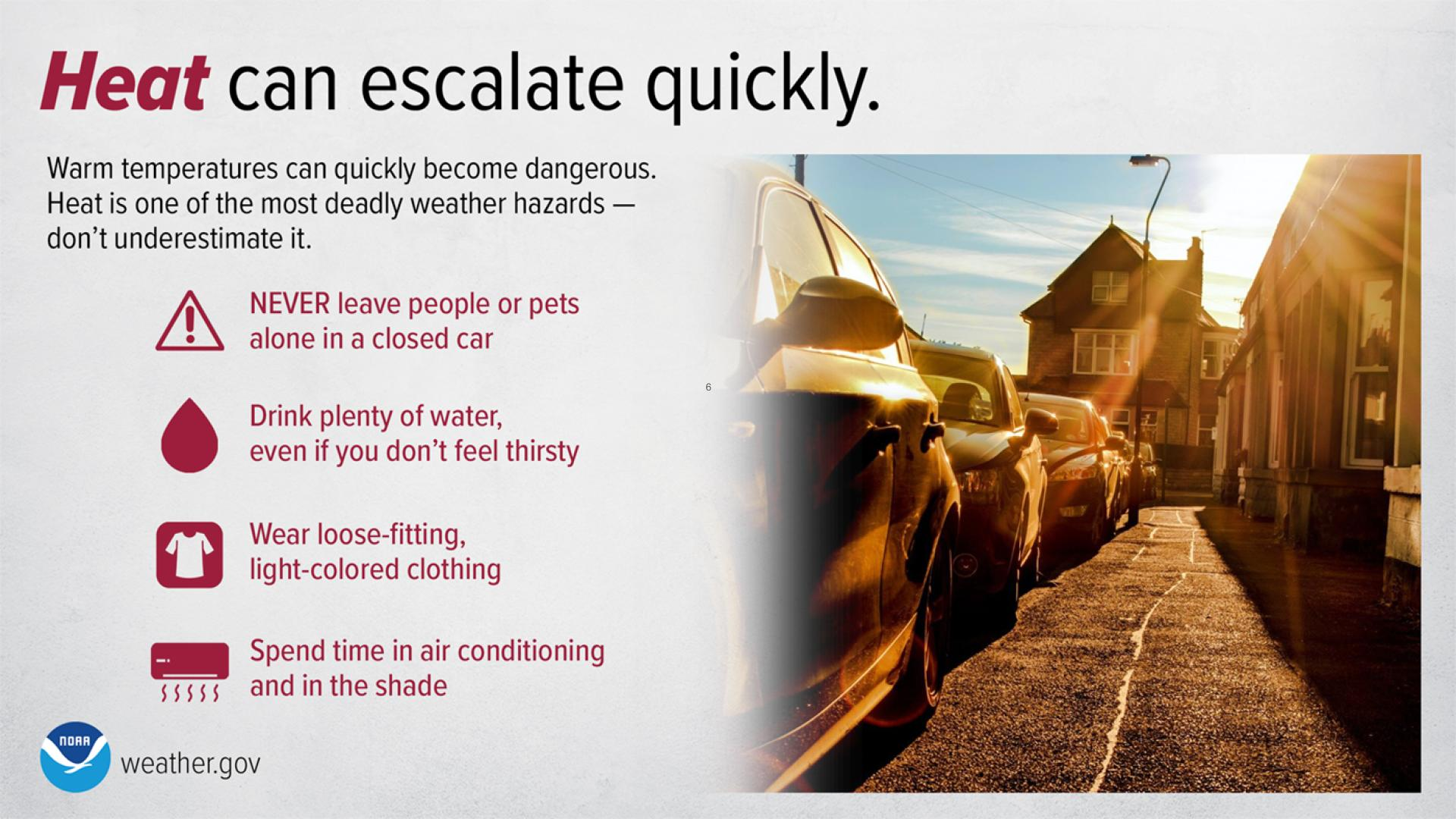
Hot weather is forecast for the local area today and tomorrow as an upper-level ridge of high pressure settles in over northern Mexico. Highs today and tomorrow will range from near 100 to 105.

The Truth Is Stranger Than Fiction!

My Web Page Is Best Viewed With Google Chrome.

Comments

My Blog Archive List (July 2010 - August 2025).

Show more

My Current Weather Conditions

MY CoCoRaHS Precipitation Data

NWS Albuquerque 2026 Winter Outlook (Updated Nov 19th).

NWS Midland Web Page

NWS Midland Web Page
Click On The Map To Open It Up

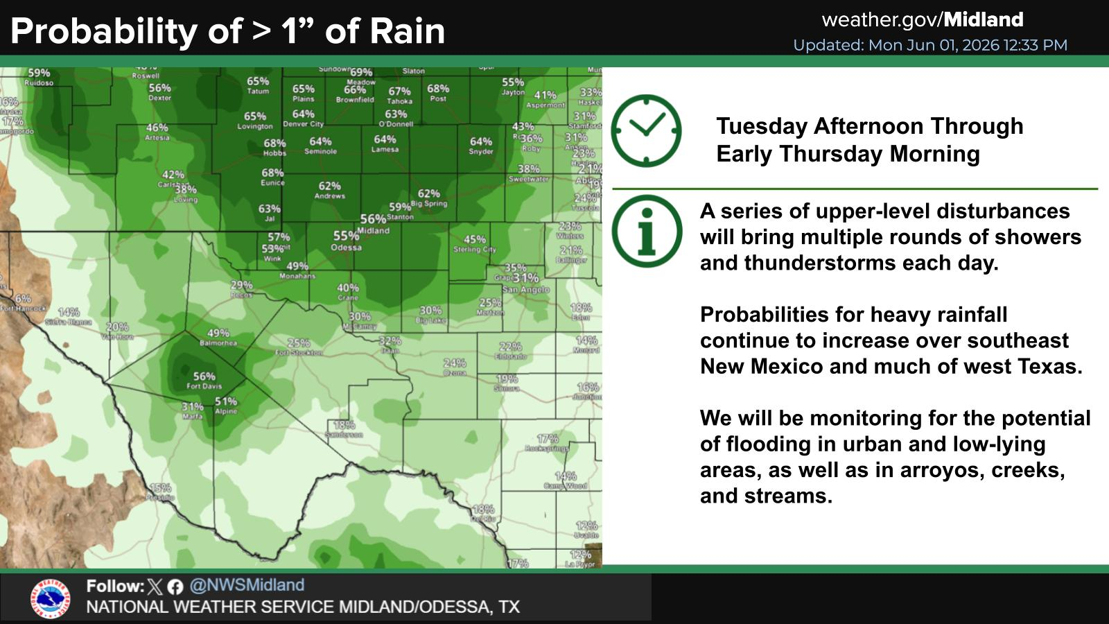
SE New Mexico & West Texas Precipitation Forecasts

Eddy County

Guadalupe Mtns Eddy & Culberson County

Lea County

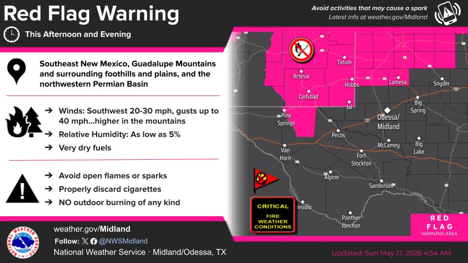
NWS Midland Hazardous Weather Outlook

NWS Midland Hazardous Weather Outlook
Click On The Image To See The Rest Of The Outlooks

NWS Midland Hazardous Weather Outlook

NWS Midland Hazardous Weather Outlook

NWS Midland Hazardous Weather Outlook

NWS Midland Hazardous Weather Outlook
Click On The Image To See The Rest Of The Outlooks

NWS Midland Forecast High Temperatures Today

NWS Midland Forecast Low Temperatures Tonight

NWS Midland Peak Wind Gust Forecast

NWS Midland Graphic Forecast

NWS Midland Graphic Forecast
A Dense Fog Advisory is in effect until 9 AM MST Saturday for the Eddy County Plains, as well as Northern and Central Lea County. When visibility is low, drive slow!

NWS Midland Forecast Graphic

NWS Midland Forecast Graphic
Patches of dense fog are once again expected tonight into Saturday morning, mainly in SE New Mexico, SE Permian Basin, and along portions of the Pecos River Valley. Skies clear and fog dissipates by Saturday afternoon, giving way to a very pleasant Saturday afternoon across the area!

NWS Midland Graphic Forecast

NWS Midland Graphic Forecast
Following a front Saturday evening/Saturday night, temperatures fall below normal across southeast New Mexico and west Texas. Highs stay below normal throughout next week thanks to reinforcing shots of cold air. A few locations (mainly in the northern Permian Basin, SE New Mexico, and in the Davis Mountains) say see their first freeze Monday and/or Wednesday mornings.

NWS Albuquerque Web Page

NWS Albuquerque Web Page
Click On The Map To Open It Up

NWS Albuquerque New Mexico Precipitation Forecasts

New Mexico

Chaves County Plains & Mtn's

Lincoln County

NWS Albuquerque Hazardous Weather Outlook

NWS Albuquerque Hazardous Weather Outlook

NWS Albuquerque Forecast High Temperatures Today

Today's High Temperature Difference From Climatology

NWS Albuquerque Forecast Low Temperatures Tonight

Tonight's Low Temperature Difference From Climatology

NWS Albuquerque Wind Chill Forecast

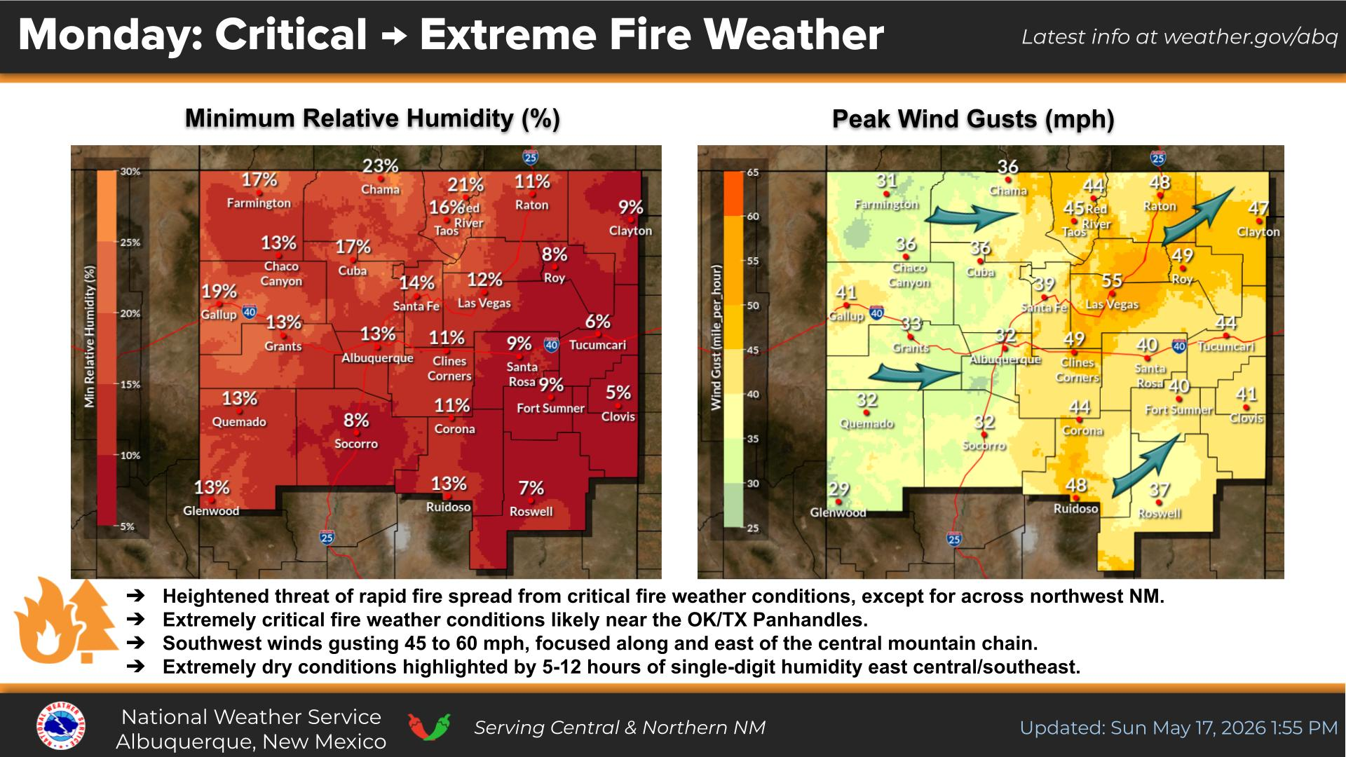
NWS Albuquerque Peak Wind Gust Forecast

NWS Albuquerque Graphic Forecast

NWS Albuquerque Graphic Forecast
Dense Fog is likely to return to areas of east-central and southeastern New Mexico tonight into Saturday morning. Low visibility as low as a quarter mile will impact the morning commute in these areas.

NWS Albuquerque Graphic Forecast

NWS Albuquerque Graphic Forecast
Gusty westerly to northwesterly winds are forecast across much of NM Saturday afternoon. Crosswinds will yield difficult travel conditions on area highways for high profile vehicles.

NWS Albuquerque Graphic Forecast

NWS Albuquerque Graphic Forecast
A cold front brings light snow accumulations to the high terrain of northern NM Saturday afternoon and night. Minor winter travel impacts from slick roads are likely through high mountain passes.

NWS Albuquerque Forecast Grpahics

NWS Albuquerque Forecast Grpahics
Colder temperatures sweep in behind a cold front Saturday night into Sunday morning when many areas are forecast to see a hard freeze.

NWS Albuquerque Graphic Forecast

NWS Albuquerque Graphic Forecast
Colder temperatures stick around into next week with most days starting off near or below freezing over much of New Mexico.

NWS El Paso Web Page

Southern New Mexico & Far West Texas Precipitation Forecasts

Texas

Otero County

NWS El Paso Hazardous Weather Outlook

NWS El Paso Hazardous Weather Outlook
Click On The Image To See The Rest Of The Outlooks

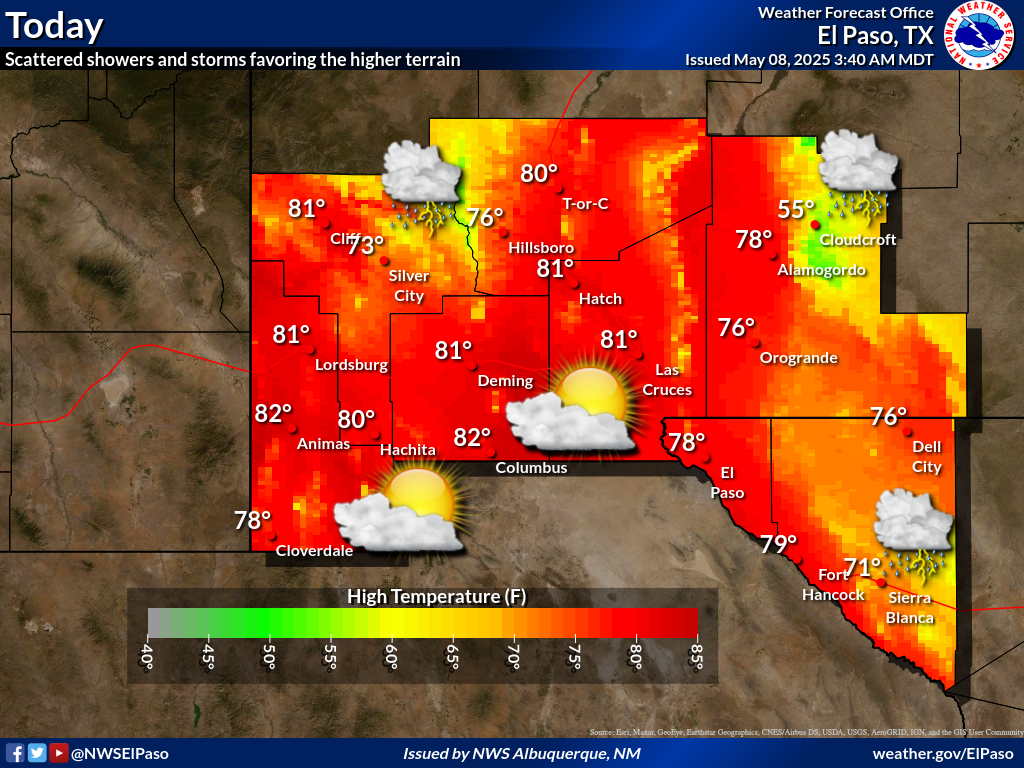
NWS El Paso Forecast High Temperatures Today

NWS El Paso Forecast Low Temperatures Tonight

NWS El Paso Wind Chill Forecast

NWS El Paso Peak Wind Gust Forecast

NWS El Paso Graphic Forecast

NWS El Paso Graphic Forecast
Temperatures for tomorrow will be below average by about 2 to 8 degrees. Skies will be partly cloudy with little chance for rain. Breezy winds at 15 to 25 mph out of the W and NW.

NWS El Paso Graphic Forecast

NWS El Paso Graphic Forecast
Dependent on how early the winds die down Sunday morning, parts of New Mexico could see their first freeze of the season.

NWS Lubbock Web Page

NWS Lubbock Web Page
Click On The Map To Open It Up

NWS Lubbock South Plains Precipitation Forecasts

NWS Lubbock Hazardous Weather Outlook

NWS Lubbock Hazardous Weather Outlook
Click On The Image To See The Rest Of The Outlooks

NWS Lubbock Hazardous Weather Outlook

NWS Lubbock Hazardous Weather Outlook
Click On The Image To See The Rest Of The Outlooks

NWS Lubbock Hazardous Weather Outlook

NWS Lubbock Hi Temperature Forecast Today

NWS Lubbock Low Temperature Forecast Tomight

NWS Lubbock Graphic Forecast

NWS Lubbock Graphic Forecast
Dense fog will impact portions of the Caprock regions this morning, primarily along and west of the I-27 corridor. Fog will linger through the morning, clearing by mid-morning. A Dense Fog Advisory is in effect through 10 AM CST. #lubwx #txwx

NWS Lubbock Graphic Forecast

NWS Lubbock Graphic Forecast
After a muggy start to the morning with areas of dense fog across the Caprock, we will see clearing skies and sunshine through the afternoon with highs in the 60s and mildly breezy southerly winds. #lubwx #txwx

NWS Lubbock Graphic Forecast

NWS Lubbock Graphic Forecast
After a mild start to the weekend with a few showers off the Caprock, much cooler weather arrives Sunday and carries into early week with another chance of rain mid-week.

My Rainfall Totals - 2.1 NNW Downtown Carlsbad

My Rainfall Totals - 2.1 NNW Downtown Carlsbad

My Seasonal Snowfall Totals - 2.1 NNW Downtown Carlsbad

My Seasonal Snowfall Totals - 2.1 NNW Downtown Carlsbad

Disclaimer

This blog and its contents are for informational purposes only! Always have multiple sources of information available to rely upon during severe weather. Do not rely solely on the Internet. Be weather-aware, plan ahead, have a backup plan, and be ready to act before severe weather strikes your location.