


Hot & Windy Midweek.

A Severe Thunderstorm Warning was issued for Central Chaves County at 2:33 AM MDT this morning, by the Albuquerque National Weather Service Office. A Severe Thunderstorm was detected by the Cannon AFB Doppler Radar 13 miles north of Roswell, or 9 miles northwest of the Bitter Lakes Wildlife Refuge, moving south at 10 mph. As of 7 AM MDT this morning, I had not received any severe weather reports in that area from this storm.
Today & This Week.


SPC Day 1 Severe Weather Outlook Issued At 6:41 AM MDT.
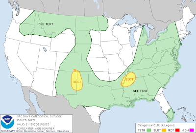 SPC Day 1 Severe Weather Outlook Issued At 10:27 AM MDT.
 Hail Threat.

Damaging Thunderstorm Wind Threat.
 Tornado Threat.
Today's Severe Weather Outlook For NE & E NM Update-
(Updated at 10:55 AM MDT)
Steep mid level lapse rates combined with today's strong afternoon heating, should yield MUCapes of around 1500 j/kg this afternoon across eastern New Mexico. Combined with a northwesterly flow aloft (30-40 kts) on top of a southeasterly flow at the surface...the results will be a few supercell thunderstorms will be possible across northeastern and eastern New Mexico this afternoon. These supercell thunderstorms will be capable of producing large hail and damaging thunderstorm wind gusts in excess of 60 mph. An isolated tornado or two will also be possible.
-----------------------------------------------------------------------


Damaging Thunderstorm Wind Threat.

Today's Severe Weather Outlook For NE & E NM Update-
(Updated at 10:55 AM MDT)
Steep mid level lapse rates combined with today's strong afternoon heating, should yield MUCapes of around 1500 j/kg this afternoon across eastern New Mexico. Combined with a northwesterly flow aloft (30-40 kts) on top of a southeasterly flow at the surface...the results will be a few supercell thunderstorms will be possible across northeastern and eastern New Mexico this afternoon. These supercell thunderstorms will be capable of producing large hail and damaging thunderstorm wind gusts in excess of 60 mph. An isolated tornado or two will also be possible.
-----------------------------------------------------------------------
A few scattered afternoon and evening thunderstorms will once again be possible across the local area. A couple of these may manage to reach severe levels especially across eastern New Mexico and northern portions of southeastern New Mexico. A few clusters of thunderstorms, and perhaps a few supercell thunderstorms will be possible this afternoon and evening, and general storm movement should be to the southeast and south.
Our afternoon high temperatures this afternoon will be a few degrees warmer than yesterday's readings, with most of us seeing the upper 80's. A few spots may reach the 90-degree mark.
An upper-level trough of low pressure is still forecast to swing across southern Colorado and northern New Mexico Wednesday and Thursday. Hot, dry, and windy conditions (blast furnace weather) are forecast to return to southeastern New Mexico Wednesday and Thursday. Critically Dangerous Fire Weather Conditions are forecast to return.
Our afternoon high temperatures are forecast to climb up into the mid-upper 90's on Tuesday, and the upper 90's to around 102 on Wednesday, and near 100 on Thursday.
Hot, very dry downslopping southwesterly winds will rake the area on Wednesday. These winds are forecast to become sustained at around 25 - 30 mph with gusts in the 35 - 45 mph neighborhood. High winds will be possible across the Guadalupe Mountains especially over and near the Guadalupe Pass area.
Late This Week Into The Memorial Day Weekend.
A secondary upper-level trough of low pressure is forecast by the models to dig southward into the Desert Southwest by the end of this week. Its exact location is still questionable, but the models are hinting that it will establish a strong southwesterly flow aloft pattern over the area, and kick out disturbances from time to time. These disturbances, combined with a sharp dryline parked across eastern and southeastern New Mexico late this week into the Memorial Holiday weekend, with give us a shot at scattered thunderstorms, some of which may be severe.
The Truth Is Stranger Than Fiction!
My Web Page Is Best Viewed With Google Chrome.


Comments
Post a Comment
Your comments, questions, and feedback on this post/web page are welcome.