Hot Again Friday - Turning Cooler & Wet This Weekend.
Sunset Over The Guadalupe's. Wednesday, August 17, 2016.
Friday.
Saturday.
Sunday.
Monday.
Valid @ 6 AM MDT Monday, August 22, 2016.
Valid @ 6 PM MDT Thursday, August 25, 2016.
Yet another late summer strong cold front will move southward down the eastern plains of New Mexico on Saturday and into southeastern New Mexico and parts of West Texas by Saturday night. Much cooler temperatures will occur behind the front on Sunday into Monday. Our daytime highs will be some 10 to 20 degrees below normal. A few locations across the lower elevations may only see their daytime highs Sunday in the 70's with most of us around 80-85ºF. Cooler in the higher elevations of the mountains of course. How about 64ºF for a high in Cloudcroft Sunday with a morning low Monday morning around 40ºF?
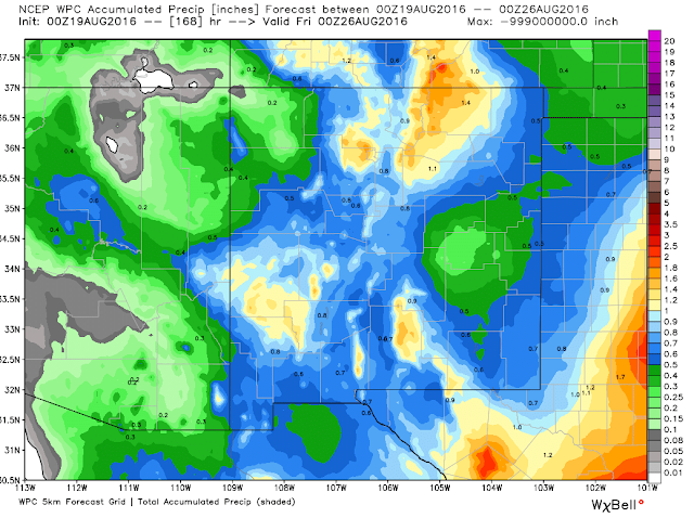
Once again scattered thunderstorms have returned to the local area. Our chances for measurable rainfall, some which again will be locally heavy over the weekend, will ramp up Saturday into Monday. I think that storm total amounts by Monday will be in the 1" to 3" range for some of us. Once again the mountains are favored to see the heaviest rainfall totals.
The Truth Is Stranger Than Fiction!


Comments
Post a Comment
Your comments, questions, and feedback on this post/web page are welcome.