Three To Six Inches Of Rain In Hobbs Overnight - Flash Flood Watch For SE NM & W TX.
Sunday, August 28, 2016.
Looking East Down US Hwy 82 Halfway Between Hope And Artesia, New Mexico.
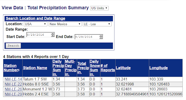
Radar Is Estimating Some Incredible Rainfall Totals From Thunderstorms Yesterday Afternoon And Evening Over The Hobbs Area, Around Seminole, And In Southwestern Lea County. Anywhere From 3" - 6" The Hobbs And Seminole Areas To 10" East Of Seminole And 8" West Of Jal.
Personal Weather Station (PWS) KM5BS Located In North Hobbs Recorded 5.88" Of Rain Overnight.
(As Of 8 AM MDT This Morning).
Another 2" to 4" of rain will fall today into Tuesday morning associated with the stronger slower moving thunderstorms, and those that train over the same areas. Isolated greater totals are also possible. The Flash Flood threat is high given how wet August has been. Most locations in SE NM have recorded 4" or rain or more.
NWS NDFD Storm Total Rainfall Forecast.
Valid @ Noon MDT Wednesday, August 31, 2016.
7-Day WPC Storm Total Rainfall Forecast.
(Valid Monday, September 5, 2016).
WRF Storm Total Rainfall Forecast.
Valid @ 6 PM MDT Wednesday, August 31, 2016.
NAM Storm Total Rainfall Forecast.
Valid @ 6 PM MDT Thursday, September 1, 2016.
Tropical Depression #9.
TROPICAL WEATHER OUTLOOK
NWS NATIONAL HURRICANE CENTER MIAMI FL
800 AM EDT MON AUG 29 2016

For the North Atlantic...Caribbean Sea and the Gulf of Mexico:

The National Hurricane Center is issuing advisories on Hurricane
Gaston, located east of Bermuda, on Tropical Depression Eight,
located southeast of Cape Hatteras, North Carolina, and on Tropical
Depression Nine, located over the extreme southeastern Gulf of
Mexico.

1. A weak trough of low pressure located just offshore of the central
coast of Texas is producing disorganized showers and a few
thunderstorms over the northwestern Gulf of Mexico and adjacent
coastal areas.  Proximity to land and only marginally favorable
upper-level winds are expected to inhibit development while the
system drifts southwestward during the next day or so.  For
additional information on the rainfall associated with this system,
please see products from your local National Weather Service office.
* Formation chance through 48 hours...low...10 percent
* Formation chance through 5 days...low...10 percent

2. A tropical wave is expected to move offshore of the west coast of
Africa later today or tonight.  Conditions are expected to be
favorable for gradual development of this system later this week
while it moves westward at 15 to 20 mph over the tropical Atlantic.
* Formation chance through 48 hours...low...near 0 percent
* Formation chance through 5 days...medium...50 percent

Public Advisories on Tropical Depression Eight are issued under WMO
header WTNT33 KNHC and under AWIPS header MIATCPAT3.
Forecast/Advisories on Tropical Depression Eight are issued under
WMO header WTNT23 KNHC and under AWIPS header MIATCMAT3.

Public Advisories on Tropical Depression Nine are issued under WMO
header WTNT34 KNHC and under AWIPS header MIATCPAT4.
Forecast/Advisories on Tropical Depression Nine are issued under
WMO header WTNT24 KNHC and under AWIPS header MIATCMAT4.

Forecaster Roberts
The Truth Is Stranger Than Fiction!


Comments
Post a Comment
Your comments, questions, and feedback on this post/web page are welcome.