Why Are My Weather Posts Missing From Facebook.

Hello everyone. I just wanted to let you know that my Facebook page was shut down without any warning by Facebook this past Saturday, June 8th. All I was told was that I had violated their community standards. I don't know what triggered that; they didn't tell me. I was told this may be permanent or for six months.
My guess is that it may be because I posted several comments and articles from my Substack page about the riots in LA, and that must have triggered/angered someone, and they complained, thus Facebook shut me down. I don't know this as fact, though. I have appealed this decision, and I'm still waiting for their reply. I have read on X that this has happened to other Facebook users posting about the LA riots as well.
I always share my weather blog posts (that I post here) on my Facebook page and my X page. This included over twelve different New Mexico and West Texas Facebook Community sites. So there are thousands of you out there (based on my views and shares of those posts) who will no longer see those posts. My Facebook page may or may not be restored.
This is another good reason (as the National Weather Service often reminds us) to have multiple ways of receiving severe weather alerts when severe weather threatens your location. My weather web page is one of those ways, and I really appreciate all of you who have and still do use it. Thank you so much!!!
If my Facebook page is restored, I will continue to share my weather blog posts and some of the NWS Watches and Warnings...as I have been doing for years now.

Wednesday Afternoon & Wednesday Nights Local Rainfall Totals.


Estimated Rainfall Totals Wednesday Afternoon.


Holloman AFB Dual Pol Doppler Radar 
Estimated Rainfall Totals Wednesday Afternoon.


Wednesday Afternoon.


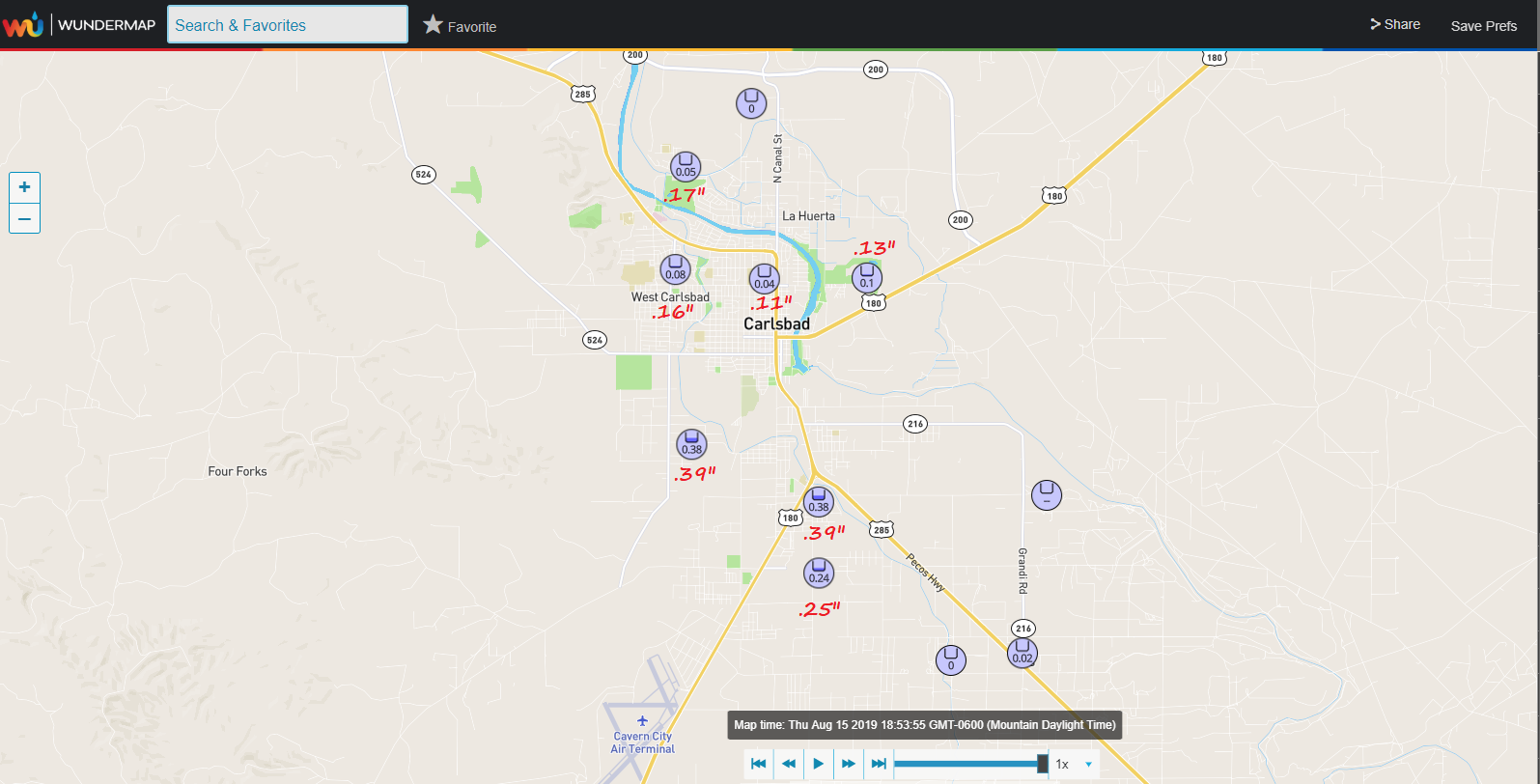
Pecos Valley Rainfall.
Wednesday Night.


In The Northern Sacramento Mountains Wednesday Night.


CoCoRaHS Rainfall Totals.
In The Pecos Valley Wednesday Night.


Rainfall Totals From Wednesday Night.


True to this summers theme rainfall-wise hit and miss thunderstorms Wednesday afternoon dumped 2" to 3" of rain in and close to the Alamogordo area. A CoCoRaHS rainfall observer measured 2.20" in Alamogordo.

Wednesday night saw a complex of thunderstorms roll southward through the Pecos Valley dropping .10" to .60" in and around the Artesia and Atoka areas, and around .50" to 1.80" in the Lakewood and Seven Rivers areas.

Carlsbad on average picked up .10" to .40" from these storms. Hobbs had a thunderstorm Thursday afternoon which left as much as .14" across the northern parts of town.

Cannon AFB Dual Pol Doppler Radar Snapshot.
(7:22 PM MDT Thursday, August 15, 2019).


Early this Thursday evening a small line of strong thunderstorms was located about 15 miles northwest-north of Roswell moving southeastward. So hopefully they will get some rain and then the rest of us in the Pecos Valley will to later tonight. A few other thunderstorms have popped up along the east slopes of the mountains also.

The Truth Is Stranger Than Fiction - And Sometimes It Hurts!

Comments

NWS Albuquerque Burn Scar Matrix

Current National Weather Service Watches/Warnings In Effect.

New Mexico

Chaves County Plains & Mtn's

Eddy County

Culberson County

Lea County

Lincoln County

Otero County

Current US Temps

Current US Wind Chill/Heat Index Temperatures

WPC 7-Day Precipitation Forecast

Roswell Live EarthCam

Ruidoso Live Webcam

Cloudcroft Live Webcam

NWS Midland 3-Day Precipitation Forecast

NWS Midland 3-Precipitation Chances

New Mexico 3-Day Precipitation Forecast

New Mexico Precipitation Chances

NWS El Paso 3-Day Precipitation Forecast

NWS El Paso Precipitation Chances

US 24-Hour Precipitation Forecast

US 3-Day Precipitation Forecast