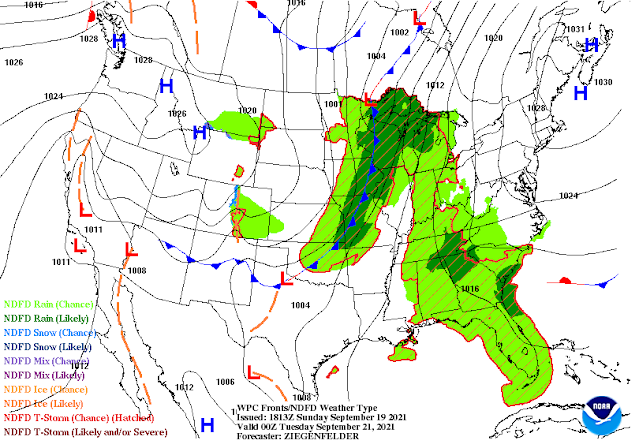
First Fall-like Cold Front Monday Evening.
High Based Thunderstorm NW Of Carlsbad, NM.
First Fall-like Cold Front Monday Evening.
Contential temperatures as of noon this Sunday show 90's across Texas and Southeastern New Mexico. Looking north into Alaska and Canada will find temps in the 30's & 40's, and the 50's in the cooler airmass headed our way.
GFS 700 MB/10,000' Temperature Forecast.
A strong mid-upper level trough of low pressure was located over the Pacific Northwest early this Sunday morning. It is forecast to continue dropping southeastward and into the central Rockies by Monday evening around sunset.
Colder temperatures at the 10,000' level of the atmosphere will work southward with the mid-level trough. By Tuesday around sunset temperatures at this level over southeastern New Mexico and parts of northern West Texas will range from around 37º to 43º.
In response to the southeastward digging mid-upper level trough of low pressure and its associated colder air mass...the season's first fall cold front will move southward through New Mexico Monday into Monday night. Cooler air will settle in over all of the state and region Tuesday and Wednesday.
Our daily high temperatures will cool off to the 70's to near 80 across the Southeastern Plains and parts of West Texas Tuesday and Wednesday. Overnight low temperatures will reflux the cooling better than the daytime highs this week. Across the Southeastern Plains lows will drop down into the 40's to near 50. Lows in the Sacramento mountains will drop down into the 30's and 40's with a few of the higher valley locations possibly seeing their first frost/light freeze for the season.
Our daily high temperatures will cool off to the 70's to near 80 across the Southeastern Plains and parts of West Texas Tuesday and Wednesday. Overnight low temperatures will reflux the cooling better than the daytime highs this week. Across the Southeastern Plains lows will drop down into the 40's to near 50. Lows in the Sacramento mountains will drop down into the 30's and 40's with a few of the higher valley locations possibly seeing their first frost/light freeze for the season.
Low Temps Monday.
High Temps Monday Morning.
Low Temps Tuesday Morning.
High Temps Tuesday.
Low Temps Wednesday Morning.
High Temps Wednesday.
Low Temps Thursday Morning.
Summer continues to hang on as we pass the midpoint of September and head towards the end of the month. Although we will get a brief break from the heat summer-like temps return again Thursday into next weekend.
For all intents and purposes, our annual summer Monsoon has come to an end. A much drier airmass has taken hold of the area and this is forecast to continue into the near future. This does not mean that we can't or won't see more rain this fall or winter but that a pattern change is underway.
(Sept 1st - Sept 16th, 2021).
The Truth Is Stranger Than Fiction!


Comments
Post a Comment
Your comments, questions, and feedback on this post/web page are welcome.