Dangerous Severe Weather Threat Today Into Tonight!
Looking East - Hail Shaft.
Northeast Of Artesia, New Mexico.
Blog Updated At 9:50 AM MDT Friday, May 26, 2023.
Dangerous Severe Weather Threat Today Into Tonight!
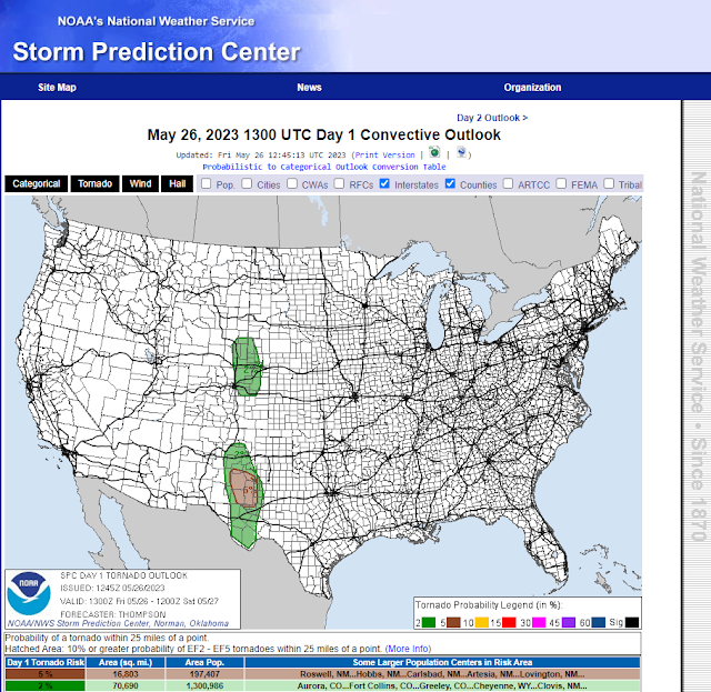
A potentially dangerous day ahead severe weather-wise for parts of eastern and especially southeastern New Mexico. As well as nearby West Texas.
Make sure you stay alert and pay attention to the weather. Have multiple ways to receive severe weather information.
Heads up southeastern New Mexico! Today will be one of those days that you must be weather-aware, especially this afternoon into tonight. The Storm Prediction Center has placed much of eastern and southeastern New Mexico in the "Enhanced" severe weather threat category. This does not happen very often but when it does we usually get clobbered with severe thunderstorms.
Scattered thunderstorms will dot the landscape today into tonight. Some of these will become severe and be capable of producing:
Tornadoes!
Scattered thunderstorms will dot the landscape today into tonight. Some of these will become severe and be capable of producing:
Tornadoes!
Large To Very Large Hail - Apple Size (3" in Diameter).
Damaging Thunderstorm Wind Gusts Of 70 MPH!
Frequent Deadly Cloud To Ground Lightning!
Locally Heavy Rainfall And Flash Flooding!
Splitting supercell thunderstorms will be possible. Typically the storm that splits to the left becomes the prolific "hailer" producing large to very large hail. The storm to the right or the right mover typically is the stronger of the two types, and will be capable of producing all modes of severe weather especially tornadoes.
Any thunderstorm that develops today will have the ability and potential to quickly become severe. Of most concern will be the right moving supercell thunderstorms that will be moving off to the east and southeast. Classic supercell thunderstorms with a few High Precipitation (HP) supercell thunderstorms are expected to develop. Later today; especially this evening into tonight, a large complex of severe thunderstorms called a mesoscale complex system (MCS) may develop and affect a large part of the local area.
Storm Prediction Center (SPC) Day 1 Severe Weather Outlooks.
   Day 1 Convective Outlook
   NWS Storm Prediction Center Norman OK
   0745 AM CDT Fri May 26 2023

   Valid 261300Z - 271200Z

   ...THERE IS AN ENHANCED RISK OF SEVERE THUNDERSTORMS THIS
   AFTERNOON/EVENING ACROSS SOUTHEAST NM AND WEST TX...

   ...THERE IS A SLIGHT RISK OF SEVERE THUNDERSTORMS THIS
   AFTERNOON/EVENING FROM NORTHERN CO TO SOUTHEASTERN MT...

   ...SUMMARY...
   A couple of tornadoes, very large hail to 3 inches in diameter and
   severe thunderstorm winds of 60 to 70 mph are possible this
   afternoon/evening across southeast New Mexico and west Texas.  Large
   hail and a few severe gusts will also be possible from northern
   Colorado to southeastern Montana.

   ...Southeast NM/southwest TX this afternoon/evening...
   A convective cluster is ongoing this morning across the TX South
   Plains. Outflow from this convection will help focus thunderstorm
   development this afternoon/evening, just east of the higher terrain.
    Within the southern stream, an embedded mid-upper speed max will
   move toward southern NM this afternoon, providing somewhat stronger
   deep-layer vertical shear/longer hodographs compared to the previous
   few days.  With boundary-layer dewpoints persisting in the 56-62 F
   range and daytime heating/mixing, MLCAPE will increase to 2000-2500
   J/kg with diminishing convective inhibition.

   The storm environment this afternoon across southeast NM/southwest
   TX will be characterized by strong buoyancy and effective bulk shear
   in excess of 50 kt.  Long hodographs will favor splitting supercells
   capable of producing very large hail up to 3 inches in diameter,
   along with damaging winds.  There will be the potential for a couple
   of tornadoes where boundary-layer dewpoints remain near 60 F,
   especially where low-level hodograph curvature and SRH are greater
   near the modifying outflow boundary later this afternoon/evening.
   Like previous days, there will be some potential for upscale growth
   into an east-southeastward moving cluster with some continuing
   severe hail/wind threat into early tonight across west central TX.
There Are None So Blind As Those Who "Will - Not" To See...107.


Comments
Post a Comment
Your comments, questions, and feedback on this post/web page are welcome.