This Weeks Storm Summary - Another Round Of Severe T-Storms Today Into Tonight!
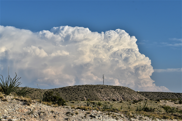
Looking South From 7 Miles Southwest Of Lakewood, NM
At A Severe Thunderstorm Just East Of Guadalupe Pass, TX.
Another Round Of Severe T-Storms Today!
Scattered thunderstorms are once again forecast to develop along the east slopes of the northern-central-south-central mountains then move east and southeast across the northeastern, eastern, and southeastern plains of New Mexico.
Large hail, damaging thunderstorm wind gusts in excess of 58 mph, locally heavy rainfall and flash flooding, and deadly cloud to ground lightning will all be possible with the stronger thunderstorms (supercells). A few tornadoes will also be possible.
A Flood Watch remains in effect through this evening for parts of northeast and east-central New Mexico.
   Day 1 Convective Outlook
   NWS Storm Prediction Center Norman OK
   0742 AM CDT Sat May 27 2023

   Valid 271300Z - 281200Z

   ...THERE IS A SLIGHT RISK OF SEVERE THUNDERSTORMS THIS
   AFTERNOON/EVENING FOR PARTS OF THE SOUTHERN AND NORTHERN HIGH
   PLAINS...

   ...SUMMARY...
   Isolated to scattered severe thunderstorms appear possible across
   much of the High Plains this afternoon and evening.  Large hail and
   severe gusts are the primary hazards.

   ...Synopsis...
   A Rex block persists from the Great Lakes to the Southeast, and as
   part of the blocking pattern, a baroclinic cyclone will drift
   northward toward the SC coast.  The surface warm sector will remain
   offshore until later tonight, at which time the cyclone will be
   slowly weakening.  Given the weakening flow aloft with time and poor
   phasing of stronger low-level shear with greater surface-based
   buoyancy, the threat for surface-based supercells to move inland
   appears low.  Farther west, weak lee troughing will persist across
   the length of the High Plains from eastern NM to eastern MT, as
   subtle/embedded shortwave troughs northeastward and northward across
   the High Plains.

   ...Northern High Plains this afternoon/evening...
   Similar to yesterday, scattered thunderstorms are expected to form
   this afternoon near the lee trough and spread northeastward before
   weakening by late evening.  Moderate buoyancy (MLCAPE of 1000-2000
   J/kg) and effective bulk shear of 25-35 kt will favor a mix of
   multicell clusters and some marginal supercells initially, with
   storms growing upscale into bands during the evening.  Occasional
   large hail and severe outflow gusts of 60-70 mph will be the main
   threats.

   ...Southern High Plains through early tonight...
   A couple of thunderstorm clusters have persisted since last night -
   one is east of Lubbock and the other is along the NM/TX border west
   of Amarillo.  These storms will slowly weaken while moving
   southeastward the remainder of the morning, with residual clouds and
   outflow slowing surface heating from northwest TX into the TX
   Panhandle.  Farther west and southwest, boundary-layer dewpoints in
   the mid 50s to low 60s persist across eastern NM and southwest TX.
   Surface heating in cloud breaks will again result in moderate-strong
   buoyancy (MLCAPE 1500-2500 J/kg), though vertical shear will be a
   little weaker compared to the previous couple of days.  Scattered
   thunderstorms are expected to form along the east slopes of the
   higher terrain, as well as the weak lee trough and any lingering
   outflow boundaries later this afternoon, and spread eastward into
   this evening.  The moisture/buoyancy and modest vertical shear will
   support the potential for some large hail with initial supercells,
   and isolated severe outflow gusts with any upscale growth into
   clusters.

   ..Thompson/Broyles.. 05/27/2023
(As Of 9 AM MDT Saturday, May 27, 2023).
(As Of 9 AM MDT Saturday, May 27, 2023).
(As Of 9 AM MDT Saturday, May 27, 2023).
(As Of 9 AM MDT Saturday, May 27, 2023).
Epic Severe Weather Bust Yesterday!
Yesterday's forecast severe weather outbreak was an epic bust for the southeastern plains. A Tornado Watch was issued for a large area of the eastern one half of the state from 2:20 PM MDT through 10:00 PM MDT. Severe weather did occur in parts of the watch area but overall it was a no go for the southeastern plains.
One severe thunderstorm blew up fast just east of Guadalupe Pass as it raced northeast at 40 mph around 9 PM last night. A Severe T-Storm Warning was issued for the Whites City, Black River Village, Carlsbad, Otis, Loving areas. Within thirty minutes the storm had all but completely collapsed.
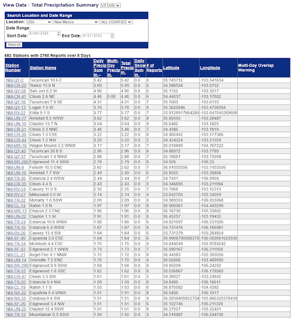
The past three days have been very active as far as severe thunderstorms are concerned across northeastern and eastern New Mexico. Clovis was hit particularly hard Thursday evening with multiple reports of hail hen egg size, along with a severe thunderstorm wind gust of 83 mph measured at the Cannon Air Force Base. Flash flooding has been an issue in some of these areas also.
Looking at the 72-hour rainfall totals from the MRMS site it is very apparent that excessive rainfall has occurred in some of these areas also. Just southeast of Tucumcari rainfall estimates exceed 12". However I don't believe that this is accurate. I think that the hail has contaminated the radar rainfall estimates in that location causing the radar to over estimate the rainfall that fell. From online available reports 4" to 6" totals have been reported in a few spots. The Clovis MesoNet Station is reporting 7.20" of rainfall over the past seven days!
There Are None So Blind As Those Who "Will - Not" To See...107.


Comments
Post a Comment
Your comments, questions, and feedback on this post/web page are welcome.