A Case Of The Haves And The Have Nots.
Wheeler Peak.
New Mexico's Highest Mountain At 13,161'.
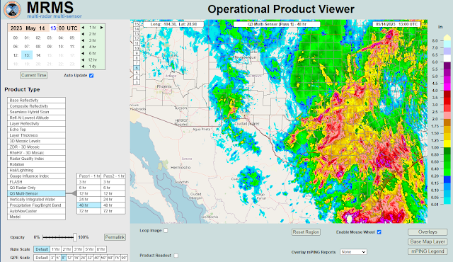
MRMS 48-Hour Rainfall Totals.
A Case Of The Haves And The Have Nots.
Southeastern New Mexico, the Sacramento, Capitan, and Guadalupe mountains pretty much got left out of this first round of showers and thunderstorms. Light rain did fall across the southeastern plains Friday night but all reported totals were less than a tenth of an inch. No measurable rain has been reported in the mountains that I can find.
Southern New Mexico and West Texas were different stories. A CoCoRaHS Station located 11.2 miles south-southeast of Deming measured a 24-hour rainfall total this morning of 2.43". A number of other stations in southwestern New Mexico measured between a half of an inch and an inch and a half of rainfall. Which was somewhat of a suprise...that was supposed to happen across the southeastern plains and mountains but didn't.
Areas generally south and east of a line running roughly from Pecos, Texas to Midland/Odessa to Big Springs picked up 2" to 6" of rainfall Friday afternoon into Saturday morning. Lucky them right?
So now we enter the typical hit and miss type rainfall pattern this upcoming work week. Daily rounds of widely scattered to scattered rain showers and thunderstorms will dot the landscape in the afternoon and evenings. Nothing excessive rainfall-wise is forecast but between today and next weekend there will likely be a few scattered locally heavy rainfall totals.
Another cutoff or closed mid/upper level low is forecast to develop over the Baja Region by mid-week and hang around into next weekend. This combined with another southward moving cold front next Friday will increase our chances for rainfall areawide midweek into next weekend.
There Are None So Blind As Those Who "Will - Not" To See...107.


Comments
Post a Comment
Your comments, questions, and feedback on this post/web page are welcome.