My Blog Archive List (July 2010 - August 2025).

Show more

About

Viewing My Web Page

If you are viewing my web page on your cell phone, then be sure and click on the three white bars located in the top left-hand corner of the page (only visible on your phone). This is the menu bar, and it opens up additional links and graphics. Such as forecast maps, severe weather outlooks, current conditions, radar and satellite links, and more.

Finally It Rained!


May 3, 2023.
Artesia, New Mexico.
Cumulonimbus Mammatus (CBMAM). 

Finally It Rained!

Yesterday I received my first measurable precipitation since Feb 20th when I measured .02". Thus ending my 72-day streak with no measurable precipitation. My last meaningful precipitation was recorded on January 20th with .13" and January 19th with .77".

Other heavier local rainfall totals received from yesterday's storms:


Public 4 Miles S of Artesia (Atoka) .25".
Public Southwest Carlsbad .28" with pea to dime size hail.
Carlsbad Airport ASOS .36"
PWS Haines - East Side of Artesia .38".
Public Ferguson Rd Otis - Southeast of Carlsbad .40".
Public King Rd in Happy Valley - Carlsbad .50".
Public Loving .50".
Guadalupe Pass ASOS .66"


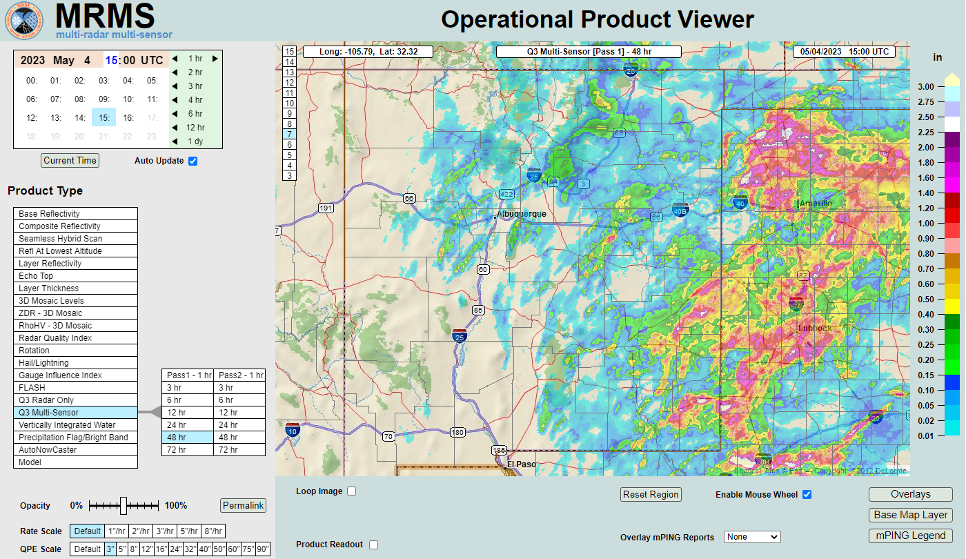
MRMS 48-Hour Rainfall Totals.


New Mexico MesoWest 48-Hour Rainfall Totals.


PRELIMINARY LOCAL STORM REPORT
NATIONAL WEATHER SERVICE MIDLAND/ODESSA TX
706 PM CDT WED MAY 3 2023

..TIME...   ...EVENT...      ...CITY LOCATION...     ...LAT.LON...
..DATE...   ....MAG....      ..COUNTY LOCATION..ST.. ...SOURCE....
            ..REMARKS..

0656 PM     TSTM WND GST     5 WSW OTIS              32.33N 104.25W
05/03/2023  M63 MPH          EDDY               NM   ASOS

            ASOS STATION KCNM CARLSBAD.
PRELIMINARY LOCAL STORM REPORT
NATIONAL WEATHER SERVICE MIDLAND/ODESSA TX
714 PM CDT WED MAY 3 2023

..TIME...   ...EVENT...      ...CITY LOCATION...     ...LAT.LON...
..DATE...   ....MAG....      ..COUNTY LOCATION..ST.. ...SOURCE....
            ..REMARKS..

0709 PM     TSTM WND GST     6 W AVALON              32.50N 104.34W
05/03/2023  M66 MPH          EDDY               NM   TRAINED SPOTTER

            SPOTTER REPORTED SUSTAINED WINDS OF 53 MPH
            WITH GUSTS TO 66 MPH FROM VEHICLE
            ANEMOMETER.
There Are None So Blind As Those Who "Will - Not" To See...107.

Comments

Current US Hazardous Weather Watch/Warning Map

New Mexico

Eddy County

Guadalupe Mtns Eddy & Culberson County

Chaves County Plains & Mtn's

Lea County

Lincoln County

Otero County

Pagosa Springs, Colorado Flooding Oct 12, 2025

Arizona Flooding - Oct 12, 2025

🔴 Live 24/7 National Weather Radar & Alerts, Weather Intensity Score & YallBot!

Ruidoso Live Webcam

Ski Apache Webcam Live Link

Ski Apache Webcam Live Link
Click On The Image To Open It Up

Cloudcroft Live Webcam

Roswell Live EarthCam

New Mexico Weather Tweets

Average Daily High/Low Temperatures & Rainfall/Snowfall

My Rainfall Totals. 2.1 NNW Downtown Carlsbad, NM.

My Top 10 Most Popular Posts

Artesia, NM Mothership Supercell Thunderstorm. 9-17-2016.

Monster Of A Snowstorm Coming This Christmas Weekend?

Powerful Winter Storm Is Hammering New Mexico! Worst Is Yet To Come.

25th Anniversary Of The Carlsbad, NM (May 31, 1991) Tornado Coming Up.

Major Winter Storm May Paralyze/Bury Parts Of NM & Nearby Areas Tonight Into Wednesday!

2011 Skywarn Spotter Training Classes & My Thoughts.

Tonight's GFS Is As Drunk As This Mornings ECMWF. Historic Snowstorm Next Weekend?

Are We Fixing To Go From Drought To Flood In SE NM?

Major Winter Storm To Hammer New Mexico & West Texas Thanksgiving Week!

Cloudcroft & Ruidoso, NM Seasonal Snowfall Totals.

My Favorite Blog List.

Substack

Disclaimer

This blog and its contents are for informational purposes only! Always have multiple sources of information available to rely upon during severe weather. Do not rely solely on the Internet. Be weather-aware, plan ahead, have a backup plan, and be ready to act before severe weather strikes your location.