Severe Thunderstorms Possible Today Into Tonight Across Parts Of E & SE NM!
(Today - Friday, June 2, 2023).
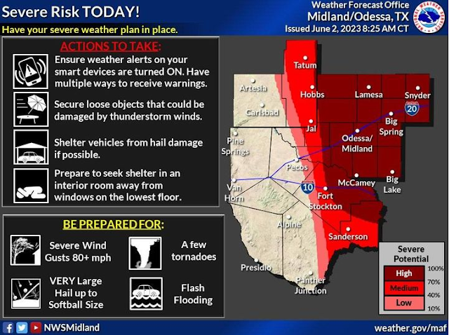
A low (10-30%), medium (40-70%), and high (70-100%) potential for severe storms exist across the Permian Basin, Lower Trans Pecos, Stockton Plateau, and portions of the Rio Grande Valley on Friday.
The highest chances for severe weather are across the Permian Basin, including Midland and Odessa, as well as along I-20 corridor.
All severe weather hazards will be possible, including very large hail, damaging wind, tornadoes, lightning, and heavy rain leading to flash flooding.
The primary threats that are of concern, especially in the area highlighted by the high potential, will be very large hail up to the size of baseballs, very strong winds, and a few tornadoes.
Start preparing now for the severe weather threat for this afternoon and evening. Ensure weather alerts on your smart devices are turned on, have multiple ways to receive warnings, reschedule outdoor plans that may be impacted by severe weather, shelter vehicles where they will not receive hail damage, tie down loose items, and if you live in a mobile home, have a plan in place to shelter in a sturdier building and be prepared to leave your mobile home.
Monitor the forecast leading up to Friday, and have a severe weather plan in place so you know where to go and what to do if severe weather strikes.
NWS Albuquerque Severe Weather Outlook Today.
Somewhat of a difficult outlook as far as severe thunderstorms are forecast to form today in my opinion. Overnight the dryline backed wester ward into southeastern New Mexico. As of 9 AM MDT is was located roughly along a line from west of Carlsbad - Artesia - Roswell. The question of the day is will the dryline mix out to the east of the Pecos Valley later this morning or afternoon?
If it does our chances of seeing severe thunderstorms in Eddy and Chaves County will decrease. If it hangs back to the west of us allowing thunderstorms to start firing up along and east of it anytime around noontime and afterwards, then we will have a higher threat for severe weather.
Current thinking is that Lea County and points eastward have the better chances for more widespread severe thunderstorms. Caution this threat may or may not shift further west. Supercell thunderstorms are expected to develop today. Later this afternoon a line of severe thunderstorms (squall line) may also develop further to our east in Lea County and West Texas. Late this afternoon and into this evening a large complex of thunderstorms called a mesoscale convective complex (MCS) may also develop. Some locations may experience thunderstorms well into the night and some of these may also be severe.
Whomever sees severe thunderstorms today may be in for a rough ride. All modes of severe weather are possible. Including:
Tornadoes.
Large To Very Large Hail - Up To Softball Size.
Damaging T-Storm Wind Gusts Excess of 80 MPH.
Frequent Deadly Cloud To Ground Lightning With Any Thunderstorm.
Very Heavy To Excessive Rainfall Which Will Produce Localized Flash Flooding.
There Are None So Blind As Those Who "Will - Not" To See...107.


Comments
Post a Comment
Your comments, questions, and feedback on this post/web page are welcome.