Why Are My Weather Posts Missing From Facebook.

Hello everyone. I just wanted to let you know that my Facebook page was shut down without any warning by Facebook this past Saturday, June 8th. All I was told was that I had violated their community standards. I don't know what triggered that; they didn't tell me. I was told this may be permanent or for six months.
My guess is that it may be because I posted several comments and articles from my Substack page about the riots in LA, and that must have triggered/angered someone, and they complained, thus Facebook shut me down. I don't know this as fact, though. I have appealed this decision, and I'm still waiting for their reply. I have read on X that this has happened to other Facebook users posting about the LA riots as well.
I always share my weather blog posts (that I post here) on my Facebook page and my X page. This included over twelve different New Mexico and West Texas Facebook Community sites. So there are thousands of you out there (based on my views and shares of those posts) who will no longer see those posts. My Facebook page may or may not be restored.
This is another good reason (as the National Weather Service often reminds us) to have multiple ways of receiving severe weather alerts when severe weather threatens your location. My weather web page is one of those ways, and I really appreciate all of you who have and still do use it. Thank you so much!!!
If my Facebook page is restored, I will continue to share my weather blog posts and some of the NWS Watches and Warnings...as I have been doing for years now.

A Few Got Lucky Concerning Rainfall- Most Of Us Not So Much.

August 2, 2023.
Wet Microburst & Rainfoot.
North Of Dunken, New Mexico.


As Of 9 AM MDT Tuesday, August 15, 2023.


As Of 8 AM MDT Tuesday, August 15, 2023.


As Of 8 AM MDT Tuesday, August 15, 2023.


As Of 8 AM MDT Tuesday, August 15, 2023.

Hit & Miss T-Storms Drop Moderate To Heavy Rainfall.

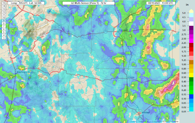
In some ways this was another bust or let down rainfall event. For a few it was not. The automated weather station located 6 miles south-southeast of Artesia at the Ag Science Center measured a 3-day rainfall total of .90". Other Personal Weather Stations (PWS) in the Artesia area measured anywhere from a little of a tenth of an inch to nearly a half of an inch of rainfall over the past three days.

The Queen Raws has recorded a 3-day total of 1.08" and the Bat Draw Raws located at the Carlsbad Caverns Visitor Center has recorded a 3-day total of 1.14". The Dog Canyon Raws has recorded a 3-day total of .56". A Personal Weather Station (PWS) in Lovington has recorded .40", and a PWS in east Alamogordo .30". 

Radar estimated that as much as 2.75" may have fallen south of the Black River Village last night. And as much as 3.80" may have fallen over the past 3-days just east of Maljamar. What looked like a good chance for moderate to heavy rainfall in the mountains over the past three days turned out to be a bust. 

Long Range Outlook. 

Weather Prediction Center (WPC) 7-Day Rainfall Forecast.


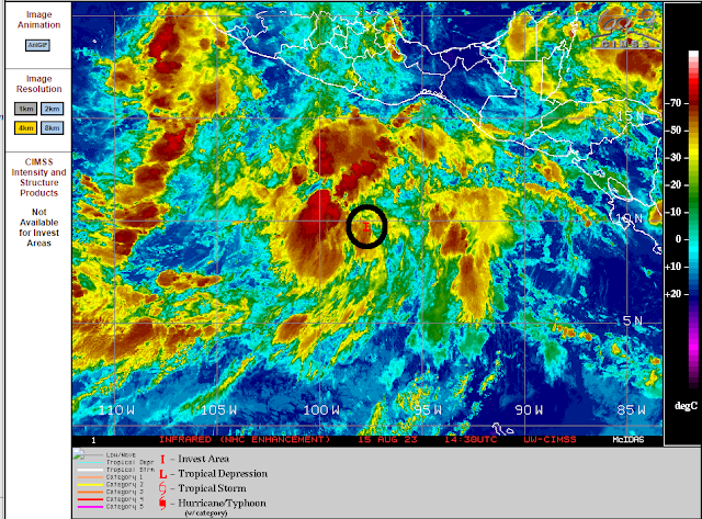
(Invest 90E).
At 8:30 AM MDT Tuesday, August 15, 2023.


This Mornings 6 AM MDT Model Forecast.


Valid At 6 AM MDT Saturday, August 19, 2023.

GFS 500 Millibar (18,000' MSL) Forecast.

Valid At 6 AM MDT Saturday, August 19, 2023.

What Happens Down The Road?

Looking at the long range model forecasts this morning it is apparent that for the near term (next 7-10 days) we aren't going to see any major changes with our local weather. This mornings model runs keep the brunt of the monsoonal moisture with the heaviest rainfall west of New Mexico in Arizona over the next week. The short range forecast keep hit and miss thunderstorms over and near the Sacramento and Capitan mountains today through Thursday. After today the southeastern plains look to remain dry through the upcoming weekend with high temps once again flirting with the century mark. 

A tropical wave is located off the southern coasts of Mexico, Guatemala, and El Salvador this morning. A tropical disturbance is forecast to develop in this area over the next 48 hours. By sunrise Saturday morning the GFS forecast model brings a hurricane northward to southwest of the tip of Baja, California. Current GFS model forecasts take this Hurricane northward to  within some 500 miles or so southwest of the San Diego coastline by next Tuesday. Last night's run of the European model tracks the Hurricane well west of the central Baja Peninsula by this time. Needless to say I don't put a lot of faith in either models forecasts yet since the Hurricane hasn't even formed. So for now this will be something to watch to see if it plays a role in our weather next week...right now early forecasts say no as far as rainfall is concerned.

This is the time of the year that the eastern Pacific starts getting active with tropical storms. Given this is an El Nino year we may see above normal activity in this region. Historically our late summer and fall months can be very wet during El Nino years with a good deal of our local rainfall coming from these Pacific Hurricanes and Tropical Storms that move inland over Mexico and dissipate, sending their remnant moisture northeastward into New Mexico. Will this be one of those wet late summers and falls?

There Are None So Blind As Those Who "Will - Not" To See...107.

Comments

NWS Albuquerque Burn Scar Matrix

Current National Weather Service Watches/Warnings In Effect.

New Mexico

Chaves County Plains & Mtn's

Eddy County

Culberson County

Lea County

Lincoln County

Otero County

Current US Temps

Current US Wind Chill/Heat Index Temperatures

WPC 7-Day Precipitation Forecast

Roswell Live EarthCam

Ruidoso Live Webcam

Cloudcroft Live Webcam

NWS Midland 3-Day Precipitation Forecast

NWS Midland 3-Precipitation Chances

New Mexico 3-Day Precipitation Forecast

New Mexico Precipitation Chances

NWS El Paso 3-Day Precipitation Forecast

NWS El Paso Precipitation Chances

US 24-Hour Precipitation Forecast

US 3-Day Precipitation Forecast