Upper Rio Ruidoso Flash Flooding - Tuesday, August 15, 2023.
GR2Analyst 3.0 Base Velocity Image.
Tuesday, August 15, 2023.
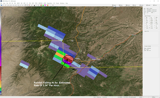
GR2Analyst 3.0 Radar Estimated Rainfall Rates.
At 1:30 PM MDT.
Tuesday, August 15, 2023.
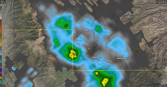
GRLevel3_2.0 Holloman AFB Doppler Radar Estimated Rainfall Totals.
At 8:29 PM MDT.
Tuesday, August 15, 2023.
Wednesday, August 16, 2023.
Tuesday, August 15, 2023.
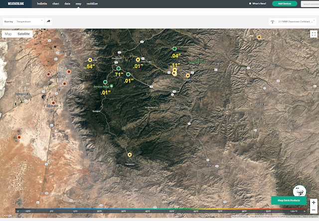
As Of 9:00 PM MDT.
Tuesday, August 15, 2023.
Yesterday I drove up to Ruidoso to shoot some video of thunderstorms developing over the area. The Albuquerque National Weather Service Office (NWS) had issued a Flash Flood Watch for Lincoln County...in particular the McBride Burn Scar and nearby local area. Later a Flash Flood Warning was issued for the Ruidoso area by the Albuquerque NWS Office.
I ran into a thunderstorm producing heavy rain in Ruidoso Downs and southeast Ruidoso around 2:30 PM. I drove up into the Upper Ruidoso Canyon on Main Rd and arrived at the USGS River Flood Gauge site on the Upper Rio Ruidoso River around 3:00 PM.
There I met Eric Queller the Ruidoso Emergency Manager. He is featured in my first photo above. I shot my photo of him from the parking lot, and which shows a lot of debris, and mud that was washed down the mountainside from the heavy rainfall.
A very small and compact thunderstorm produced estimated rainfall rates in excess of 3" per hour as per the El Paso/Santa Teresa National Weather Service Doppler Radar. The Holloman AFB Doppler Radar estimated a storm total of 2.72" of rainfall. Actual measured storm total rainfall amounts include:
The USGS River Flood Gauge On The Upper Rio Ruidoso River recorded 2.62" of rain from this storm. A Personal Weather Station (PWS) located on the north side of the Rio Ruidoso (Far Upper Canyon) nearby recorded 2.29".
The USGS River Flood Gauge On The Upper Rio Ruidoso River recorded 2.62" of rain from this storm. A Personal Weather Station (PWS) located on the north side of the Rio Ruidoso (Far Upper Canyon) nearby recorded 2.29".
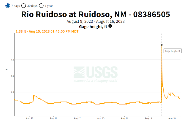
Just down the mountain and in central Ruidoso the NWS Climate Co-Op Station on managed to pick up .39" from this storm. This was an amazingly small but potent thunderstorm that produced highly localized heavy rainfall in a brief time frame...generally in less than an hour. This is a classic example of "hit and miss" type air mass summertime thunderstorms that can, and sometimes do, produce locally heavy rainfall, and localized flash flooding. Thankfully this storm did not produce more widespread heavy rainfall which would have led to a lot more flash flooding than what occurred yesterday afternoon. The Upper Rio Ruidoso briefly rose up 1.2' then receded quickly.
Remnant tropical moisture from former Gulf of Mexico Hurricane Dolly produced some of the most significant widespread flash flooding in the Ruidoso area on July 26th and 27th, 2008. Referenced below are quotes from my blog post published on April 18, 2019.
Remnants Of Hurricane Dolly July 27, 2008.
At the end of July, 2008 Hurricane Dolly moved inland near Brownsville, Texas as a Category 1 Hurricane. Her remnant moisture then moved northwestward up the Rio Grande Valley and into southern New Mexico. During the night of Saturday July 26th into the following day, excessive rainfall fell over the Sacramento Mountains, and the Sierra Blanca Wilderness drainage area west of Ruidoso, New Mexico.
Excerpts From My Blog July 27, 2008-
"As a result, some of the worst flooding in 100 years occurred in Ruidoso, New Mexico late Saturday night into Sunday. The Rio Ruidoso River rose to over 11 feet in Ruidoso, and the Mescalero Lake at the Inn of the Mountain Of Gods rose to within a foot of the spillway. Bonito Lake was overflowing it's spillway.
Many roads in the Ruidoso area were closed including US 70 Saturday and Sunday. Twelve bridges were washed out, with some estimates of 20-25 bridges having gone under water. Some 350-500 homes have been flooded and damaged, at least 25 people have been rescued out of the flood waters. Nearly 900 people stranded by the flood waters had been rescued in and around the Ruidoso area. One 20 year old man who slipped in the flood waters in the upper canyon and drowned was found Monday morning.
200 residents remained stranded in the upper canyon area in west Ruidoso as of Monday due to the bridges and roads being washed out.
US 70 was reopened but 60% of the secondary roads in and around Ruidoso remained closed Monday. Early estimates put the damages in Ruidoso alone at 15-20 million dollars."
Two Day Rainfall Totals From Ruidoso Include-
(July 27- 28, 2008).
2.0 N Ruidoso Spotter 7.00"
1.8 SW Ruidoso 6.76"
Downtown Ruidoso Spotter 6.60"
4.0 N Ruidoso Public 6.30"
1.0 W Ruidoso Fire Dept 4.67"
Capitan Climate 3.93"
24 HR & (2 Day) Storm Total Rainfall Amounts-
(As Of 11 A.M. MDT Sunday Morning).
Lincoln County
Smokey Bear Raws Ruidoso 5.54” (6.76”)
Sierra Blanca Pk Snotel 5.50” (7.30”)
3.9 NNW Ruidoso 3.43" (4.28") 7 AM
Sierra Blanca Regional Arpt 2.39” (2.94”)
Otero County
0.7 N Sunspot 6.58" (6.99") 7 AM
Cosmic Raws Sunspot 6.30”
5.8 ENE La Luz 4.60" (4.70") 7 AM
5.8 WSW Cloudcroft4.56" (4.56") 7 AM
2.1 SSE Alamogordo 4.44" (4.44") 7 AM
1.0 E Tularosa 4.25" (4.53") 7 AM
0.3 SSW Tularosa 3.94" (4.18") 7 AM
16 ESE Cloudcroft 3.73" (4.49") 7 AM
8.5 NE Alamogordo 3.71" (3.92") 7 AM
Mescal Raws Near Mescalero 3.74" (4.48")
Mayhill Raws 3.58” (5.20”) (July 14.69”)
4.0 E Cloudcroft 3.50" (4.09") 7 AM
Ponderosa Pines Golf Course 3.45” (3.46”)
1.5 NE Timberon 3.40" (4.35") 7 AM
5.4 W Cloudcroft 3.37" (3.59") 7 AM
11.8 E Cloudcroft 3.30" (4.44") 7 AM
2.3 NE Alamogordo 3.27” (3.43”) 7 AM
0.4 ESE Cloudcroft 3.08" (3.48") 7 AM
Cloudcroft Fire Stn 2.89” (2.94”)
Dark Ridge Observatory 3.88” (July 11.62”)
Dry Canyon N Wimsatt 2.71’ (2.71”)
High Roll CW5738 2.65” (2.65”)
Holloman AFB 2.17” (2.55”)
Its hard to believe but 11" - 15" of rain fell over the Sacramento Mountains during the month of July! Most of this was attributed to the remnants of former Hurricane Dolly. That's two-three times the normal average. Cloudcroft typically sees on average about 5.50" of rain in July and Ruidoso about 4.50".
The Cloudcroft Climate Coop Station recorded 13.33" for July. A CoCoRaHS Station 16 miles ESE of Cloudcroft recorded 15.82" of rain for July. The Mayhill Raws recorded 15.71" of rain for July. The Cosmic Raws at Sunspot recorded 13.58" for July while the Smokey Bear Raws in Ruidoso recorded 10.87" of rain. The Ruidoso Climate Coop Station recorded 10.57" of rain for July. The Capitan Climate Coop Station recorded 7.15" of rain for July.
Former hurricane Dolly brought tropical moisture into New Mexico, producing heavy precipitation as high as 7 inches around Ruidoso. This rain caused the Rio Ruidoso and Rio Bonito to rise well above flood level and widespread, serious flooding occurred from the upper canyon of the Rio Ruidoso downstream through the towns of Ruidoso, Hollywood and Ruidoso Downs as far east as Fox Caves. Flooding also occurred along the Rio Bonito from the dam at Bonito Lake downstream to State Road 48.
The flooding was extensive in Ruidoso, not only along the Rio Ruidoso, Cedar Creek and other small streams, but also throughout the town. Local rain reports were 6.3 to 7.0 inches. One man was killed when he was swept away by the raging Rio Ruidoso; no substantial injuries were reported. A total of 500 structures, including campers and mobile homes were damaged. Around 200 houses were damaged, some were completely destroyed. At least 13 bridges were washed out and several cars were washed downstream. Several dozen recreational vehicles and campers were damaged at an RV park at Ruidoso Downs. Damages in Lincoln County along were estimated to be $25 million.
The remnants of Hurricane Dolly also impacted areas in south central New Mexico as the circulation associated with the system moved directly over El Paso, TX, then curved north and northeastward into Otero County. Moisture from this system spread over most of southern New Mexico and lingered another 36 hours. Storm totals from early July 26 into the 27th peaked at more than 4 inches in the Santa Teresa Country Club area, with 2.5 to 3.5 inches of rain to southern Dona Ana County. Water was knee deep in Chaparral, and Highway 28 was flooded south of La Union.
There Are None So Blind As Those Who "Will - Not" To See...107.


Comments
Post a Comment
Your comments, questions, and feedback on this post/web page are welcome.