Hit & Miss T-Storms Today Into Thursday As The SE Plains Head Back Into The Broiler!
Northeast Of Carlsbad, New Mexico.
Junction St Hwy 360 & US hwy 62/180.
(As Of 9 AM MDT Wednesday August 2, 2023).
(As Of 9 AM MDT Wednesday August 2, 2023).
(As Of 9 AM MDT Wednesday August 2, 2023).
(National Weather Service Climate Co-Op Stations).
(July 1st - July 30th, 2023).
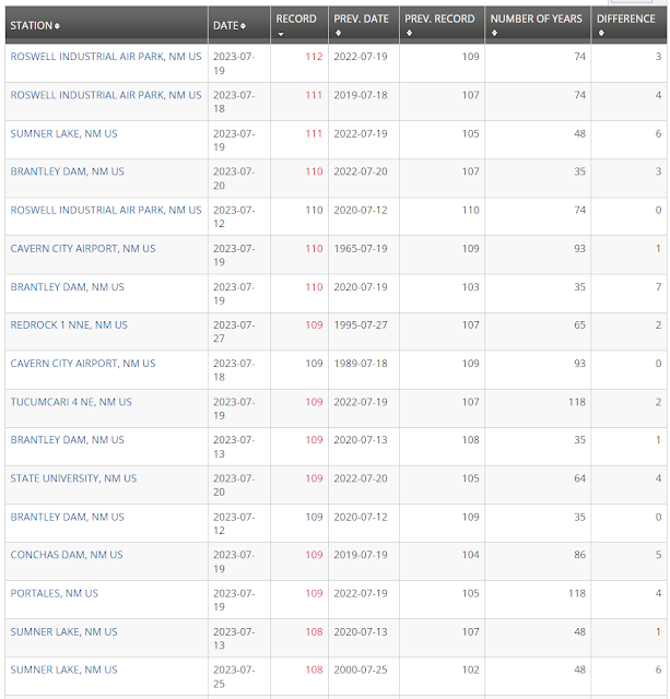
New Mexico.
Click on the link above to view the rest of the records for New Mexico.
Chaves County.
Otero County.
Hit & Miss T-Storms As The SE Plains Broil AGAIN!
Scattered hit and miss thunderstorms remain in our local forecasts today and tomorrow across the southeastern plains. Our chances for measurable rainfall are only in the 20% to 30% range.
A better chance for scattered thunderstorms with isolated locally heavy rainfall possible exists across the Sac's today into the upcoming weekend.
It will continue hot across the southeastern plains with highs today into Friday ranging from 101º to 105º. By the weekend our afternoon highs soar back up close to 107º - 110º.
Long-range forecasts continue to look dismal as far as drought relief is concerned and a much needed break from the brutal summer heat. I'm hoping El Nino will do its thing and cause a pattern change later this month towards cooler and wetter weather but so far I don't see that happening...yet.
Goodbye July & Good Riddance!
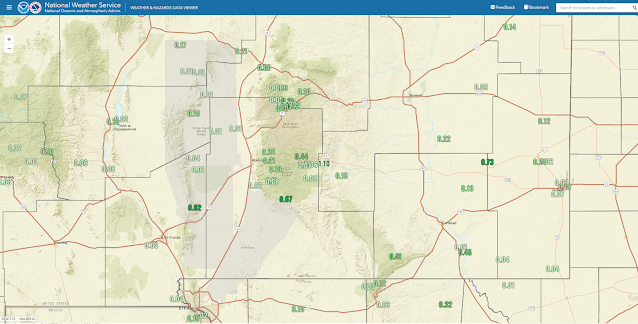
This past July was one of the hottest if not the hottest on record for the area. There were 318 new daily record high temperatures (preliminary) set in New Mexico as of July 30th. Not only was it brutally hot but extremely dry for the southeastern plains. Rainfall was also below average in the Sacramento mountains.
Looking at the CoCoRaHS July rainfall totals 2.99" of rainfall was measured at Ruidoso 1.4 miles south-southwest. 3.07" was measured at Mayhill 2.8 miles west-northwest.
The Carlsbad Airport ASOS measured .11" of rainfall for the month of July. This compares to the long term average (1930 - 2023) of 1.76".
The Artesia Climate Co-Op Station measured .68" of rainfall for the month of July. This compares to the long term average (1905 - 2023) of 1.67".
The Roswell Airport ASOS measured .24" of rainfall for the month of July. This compares to the long term average (1893 - 2023) of 1.82".
The Hobbs Airport AWOS measured .72" of rainfall for the month of July. This compares to the long term average (1941 - 2023) of 1.81".
The Ruidoso Climate Co-Op Station measured .96" of rainfall for the month of July. This compares to the long term average (1941 - 2023) of 4.31".
The Cloudcroft Climate Co-Op Station measured 1.93" of rainfall for the month of July. This compares to the long term average (1987 - 2023) of 5.53".
The Mountain Park Climate Co-Op Station measured 2.19" of rainfall for the month of July. This compares to the long term average (1894 - 2023) of 3.59".
The Alamogordo Airport AWOS measured .09" of rainfall for the month of July. This compares to the long term average (1913- 2009) of 1.62" at the Climate Co-Op Station, which is no longer in service.
There Are None So Blind As Those Who "Will - Not" To See...107.


Comments
Post a Comment
Your comments, questions, and feedback on this post/web page are welcome.