Seasonal Weather Continues.
Right Click On The Maps To Open Them In A Separate Window.
Today's Outlook.
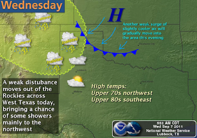
Near seasonal temps along with dry weather are forecast for the Pecos Valley and surrounding areas today. Most of the valley locations will see afternoon highs near 90. A weak cold front will move in tonight, which will knock our daytime highs back down into the low-mid 80's tomorrow and Friday. A warm-up commences this weekend with our highs climbing back up into the 90's, and the mid-upper 90's for the first of next week.
------------------------------------------------------------------------------
Update At 5:30 PM MDT-
Tropical Storm Nate.
Visible Satellite Of Tropical Storm Nate At 4:45 PM MDT.
NHC 5-Day Forecast Track Of Nate.
Tropical Storm Nate formed about 125 miles west of Campeche, Mexico this afternoon. At 3 PM MDT, Nate had sustained winds of 45 mph with higher gusts. His central pressure was down to 1004 millibars, or 29.65 inches of mercury. He is slowly crawling off to the ESE at 2 mph. There is a great deal of uncertainty concerning Nate's future track and strength. He is forecast to gain Hurricane strength by tomorrow afternoon.
----------------------------------------------------------------------------------
Invest 96L
(Nate?)
Valid At 12Z/6 AM MDT Sat Sept 10, 2011.
The NAM wants to develop a strong Hurricane
in the northern Bay of Campeche by sunrise
Saturday. This may or may not happen.
An area of disturbed weather (Invest 96L) in the Bay of Campeche, has the potential to become the next named storm of the 2011 Atlantic Hurricane season. Should this occur then this next potential Tropical Storm would be named Nate. The models are all over the place with Nate's potential forecast track so there is much uncertainty as to what he may do this weekend.
The Truth Is Stranger Than Fiction!


Comments
Post a Comment
Your comments, questions, and feedback on this post/web page are welcome.