Eddy County Flash Flooding - September 12, 2013.
Click On The Photos To Enlarge Them.
Blog updated Sunday, Sept 15, 2013. 7:05 AM MDT.
Blog updated 6:27 AM MDT, Monday, Sept 16, 2013.
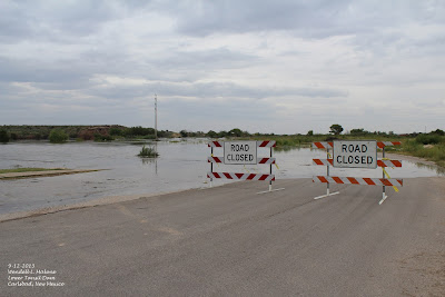
Rocky Arroyo.
St. Hwy 137 - 11 Miles Northwest Of Carlsbad, NM.
Thursday September 12, 2013.
Friday September 13, 2013.
Thursday September 12, 2013.
Friday September 13, 2013.
Friday September 13, 2013.
Flood Waters Flowed With Enough Force To Wash Away The
Cattle Guard Here On Rocky Arroyo.
North Seven Rivers Arroyo.
Lakewood, New Mexico.
Thursday September 12, 2013
Thursday September 12, 2013.
Friday September 13, 2013.
Thursday September 12, 2013.
Thursday September 12, 2013.
Friday September 13, 2013.
The Flood Waters From North Seven Rivers Arroyo Did Come
Onto The Top Of US Hwy 285.
Friday September 13, 2013.
The Fast Flowing Waters Chewed Up The Edge Of The Asphalt.
Friday September 13, 2013.
Meteorologist Jim Deberry From The Midland National Weather
Service Office Inspecting The Flooding On Four Mile Draw One
Day After It Peaked At 10.01' On 9-12-2013.
Pecos River.
Callaway Drive - Carlsbad, New Mexico.
Thursday September 12, 2013.
Thursday September 12, 2013.
Thursday September 12, 2013.
Friday September 13, 2013.
Pecos River.
Beach Area - Carlsbad, New Mexico.
Thursday September 12, 2013.
Thursday September 12, 2013.
Thursday September 12, 2013.
Lower Tansil Dam.
Thursday September 12, 2013.
Lower Tansil Dam.
Thursday September 12, 2013.
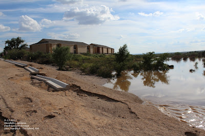
Dark Canyon Arroyo.
Boyd Drive & Radio Blvd.
Carlsbad, New Mexico.
Thursday September 12, 2013.
Thursday September 12, 2013.
Thursday September 12, 2013.
Thursday September 12, 2013.
Friday September 13, 2013.
Dark Canyon Arroyo.
San Jose Blvd - Carlsbad, New Mexico.
Friday September 13, 2013.
Dark Canyon Arroyo.
San Jose Blvd - Carlsbad, New Mexico.
Friday September 13, 2013.
Friday September 13, 2013.
Meteorologist Jim Deberry Inspecting The Flood Damage On San Jose
Blvd In Carlsbad, New Mexico.
Friday September 13, 2013.
Meteorologist Jim Deberry Inspecting The Flood Damage On San Jose
Blvd In Carlsbad, New Mexico.
Friday September 13, 2013.
Friday September 13, 2013.
Friday September 13, 2013.
Dark Canyon Arroyo.
Hidalgo Rd - Carlsbad, New Mexico.
Friday September 13, 2013.
Friday September 13, 2013.
Friday September 13, 2013.
Dark Canyon Arroyo.
Hidalgo Rd - Carlsbad, New Mexico.
Friday September 13, 2013.
SE New Mexico Storm Total Rainfall Amounts From This Event.
A historic rain event for the Guadalupe Mountains from September 9th-13th, 2013. 15.76 inches of rain was recorded during this period at the Pine Springs, GUMO mesonet station near the National Park Visitor Center. 13.62 inches of rain fell on September 11th-12th (most of this in a 12-hour period during the early morning hours of the 12th). Flash flooding occurred in the Dark Canyon, Rocky Arroyo and Black River basins on the 12th with many localized areas of high water along the arroyo's on the north side of the Guadalupe Mountains. An impressive fourteen-foot rise of water on the Dark Canyon when it reached Carlsbad, New Mexico creating some damage in the city to low-lying areas...along with some welcome water in the Pecos River Basin down to Red Bluff Reservoir.
The Truth Is Stranger Than Fiction!
My Web Page Is Best Viewed With Google Chrome.


Comments
Post a Comment
Your comments, questions, and feedback on this post/web page are welcome.