Posts

Showing posts from December, 2020

Major Winter Storm Bearing Down On Us.

Image
Longwave IR Satellite Image. Valid At 4:41 AM MST Wednesday, December 30, 2020. RAP 500 MB (18,000') Analysis. Valid At 4:00 AM MST Wednesday, December 30, 2020. RAP 700 MB (10,000') Analysis. Valid At 4:00 AM MST Wednesday, December 30, 2020. RAP 850 MB (5,000') Analysis. Valid At 4:00 AM MST Wednesday, December 30, 2020. Upper-Air Analysis Of The Storm. A couple of important developments are occurring with our powerful mid-upper level winter storm located to our west early this morning. I've posted an analysis of the storm starting at the 18,000' level with the first map. Interestingly enough a "low" appears to be trying to close off over southwestern New Mexico as of 4 AM. Along with the possibility of a second low developing further south in northern Mexico.  This is important because the storm may be trying to develop further north than what the models have been forecasting. This potentially could mean heavier snow for southern and Southeastern New M...

Our Next Winter Storm Is Getting Stronger & Slowing Down.

Image
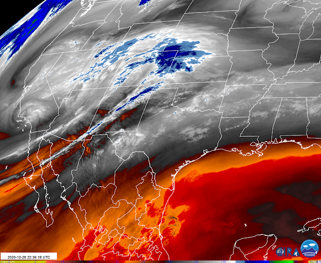
Water Vapor Satellite Image. Snapshot At 3:22 PM MST Monday Afternoon. European (ECMWF) 500 MB (18,000') Forecast. Valid At 5 AM MST New Years Morning. European (ECMWF) Snowfall Forecasts. Surface Map Forecast. Upcoming Weather - Courtesy Of NWS Midland. A Winter Storm Is In The Making. But many questions are still unanswered tonight. Two of the more important questions are how much snow falls, and where? Sorry, I don't have a good answer for this just yet.  A Pacific cold front is forecast to sweep across the area Tuesday afternoon and evening. Ahead of it, a dry line is forecast to develop across Southeastern New Mexico and West Texas Tuesday. Along and ahead of this dry line scattered thunderstorms are forecast to break out. And a few of these may possibly become marginally severe Tuesday night into Wednesday morning. With the best chance of this happening in West Texas.  Low clouds, fog, and patches of light rain or light drizzle are forecast to overspread parts of the loc...

2020 To End Colder With Some Snow For New Mexico.

Image
December 27, 2020. Cloudcroft, NM Ski Area. Sadly another Christmas with no meaningful snow cover on the ground in Cloudcroft, New Mexico (8,751'). I took this photo Sunday afternoon just east of Cloudcroft looking up from the base of the Ski run. Although the ski run is currently closed due to the lack of snow the tubing area is open for business...they are making snow.  GFS 500 MB (18,000') Analysis. Valid At 11 AM MST Sunday Morning. GFS 500 MB (18,000') Forecast. Valid At 5 PM MST Tuesday Afternoon. Surface Map Forecasts. 5 AM MST Monday Morning. 5 PM MST Monday Evening. 5 AM MST Tuesday Morning. 5 PM MST Tuesday Evening. NWS NDFD Snowfall Forecast. Valid Sunday Night - Wednesday Afternoon. NWD Precipitation Forecasts. Valid Sunday Night - Wednesday Afternoon. NWS NDFD High-Temperature Forecasts. Monday. Tuesday. Wednesday. New Year's Eve. New Years Day. NWS NDFD Low-Temperature Forecast. Thursday Morning. Next Winter Storm Taking Aim On NM. Our next inbound winter ...

No White Christmas For SE NM This Year.

Image
Seasonal Snowfall To-Date. (Oct 1 - Dec 20, 2020). NWS NDFD Christmas Week Forecast Temperatures. NWS NDFD Forecast High TemperaturesTuesday. NWS NDFD Forecast High Temperatures  Wednesday. NWS NDFD Forecast Low Temperatures Christmas Eve. NWS NDFD Forecast High Temperatures Christmas Eve. NWS NDFD Forecast High Temperatures Christmas. NWS NDFD Snowfall Forecast. ECMWF 500 MB (18,000' Forecast). Valid At 11 PM MST Wednesday Night. NWS Surface Map Forecast. Valid At 5 AM MST Wednesday Morning. No White Christmas This Year. Christmas this year will not be white for the majority of New Mexico. With the exception of those mountain communities that already have snow on the ground. A mid-upper level short wave trough of low pressure will sweep across New Mexico on Wednesday. This will send a cold front southward into the state Tuesday night into Wednesday. It will also help produce a few light snow showers over the northern mountains and far northeastern plains. At this time generally, l...

Current National Weather Service Watches/Warnings In Effect.

New Mexico

Chaves County Plains & Mtn's

Eddy County

Culberson County

Lea County

Lincoln County

Otero County

Current US Temps

Current US Wind Chill/Heat Index Temperatures

WPC 7-Day Precipitation Forecast

Roswell Live EarthCam

Ruidoso Live Webcam

Cloudcroft Live Webcam

NWS Midland 3-Day Precipitation Forecast

NWS Midland 3-Precipitation Chances

New Mexico 3-Day Precipitation Forecast

New Mexico Precipitation Chances

NWS El Paso 3-Day Precipitation Forecast

NWS El Paso Precipitation Chances

New Mexico 3-Day Snowfall Forecast

New Mexico Snowfall Chances

NWS El Paso 3-Day Snowfall Forecast

NWS El Paso Snowfall Chances

US 24-Hour Precipitation Forecast

US 3-Day Precipitation Forecast

US 24-Hour Snowfall Forecast

US 3-Day Snowfall Forecast