

Sunspot Count Continues To Dwindle.
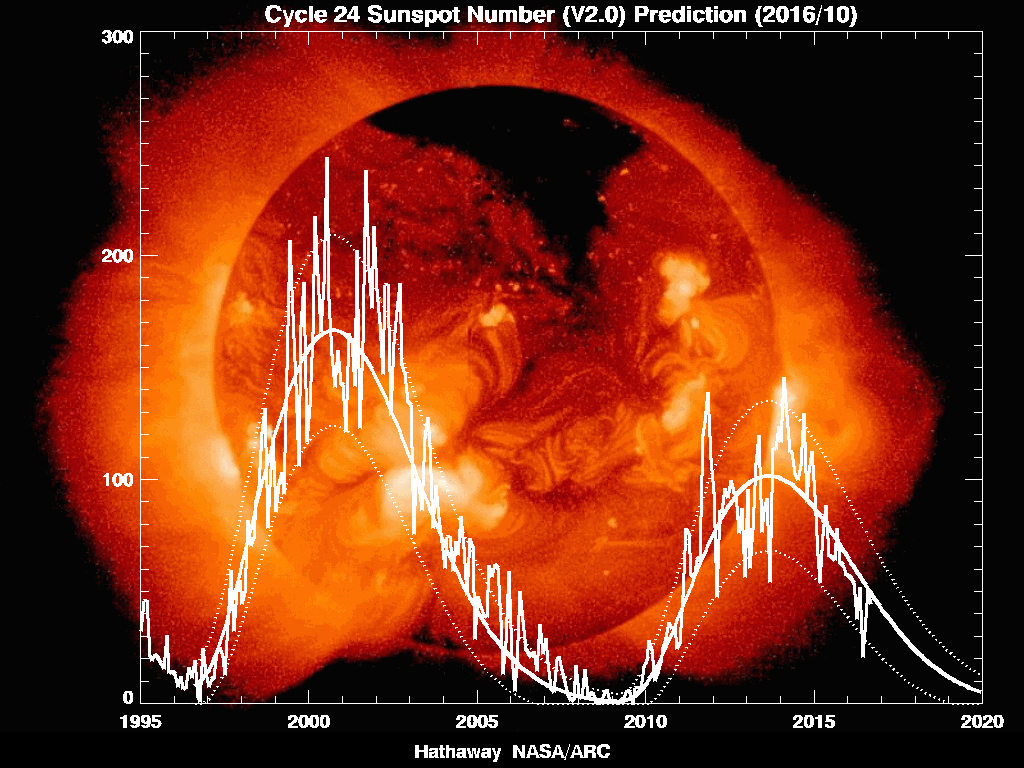
"Current prediction for the next sunspot cycle maximum gives a smoothed sunspot number maximum of about 59 in June/July of 2013. We are currently two years into Cycle 24 and the predicted size continues to fall."
The Maunder Minimum-
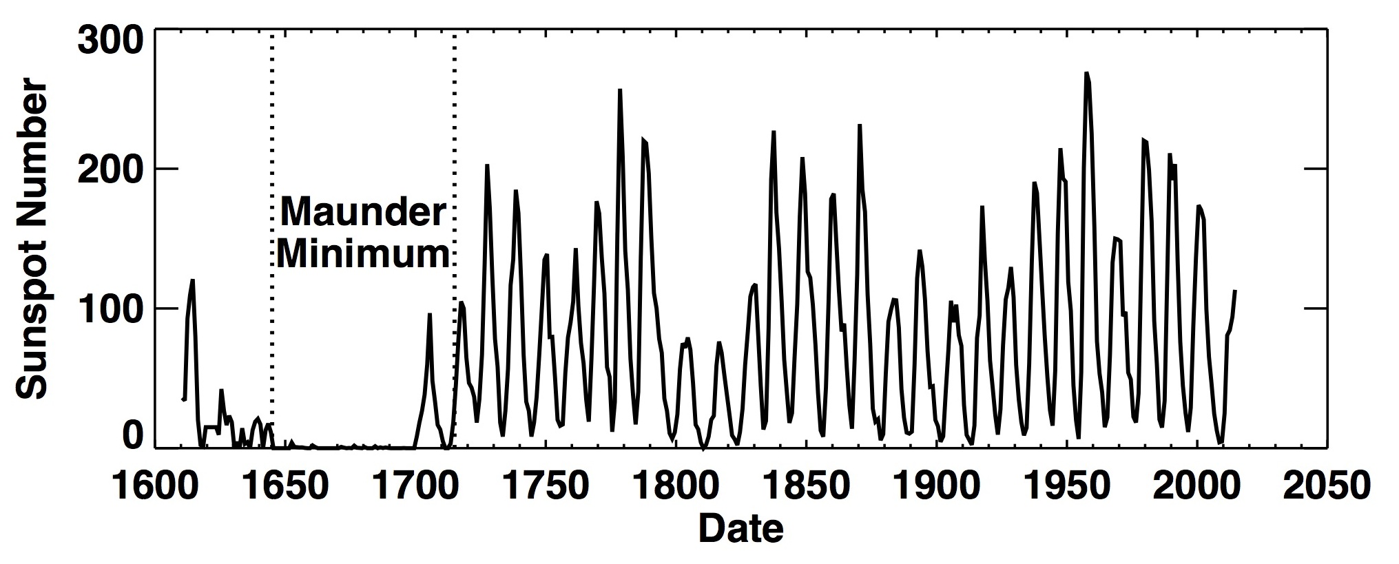
"Early records of sunspots indicate that the Sun went through a period of inactivity in the late 17th century. Very few sunspots were seen on the Sun from about 1645 to 1715 (38 kb JPEG image). Although the observations were not as extensive as in later years, the Sun was in fact well observed during this time and this lack of sunspots is well documented.
---------------------------------------------------------
"WUWT Commenter J Gary Fox writes"-
"The solar cycle 24 predicted sunspot maximum has been reduced again – predicted peak down to 59 Max. (1/3/11) http://solarscience.msfc.nasa.gov/predict.shtml
This will be at the level of the Maunder Minimum of 1675 -1715."
----------------------------------------------------------
----------------------------------------------------------
My Own Thoughts On This-
I have always been fascinated by the sunspot cycle. And as I have stated before, I never bought into the "Global Warming Madness" that has so griped the world recently. I cried foul on this back in the 1980's.
Our sun continues to remain very quiet concerning the current sunspot cycle, and this is getting a lot of peoples attention. There is good reason for this, at least I believe anyway, why it should. Some scientists believe that we will be in another "Mini-Ice Age" or flat out in one, in roughly 30 years or so. So say it may be sooner. Many don't think that this will happen.
AccuWeather Meteorologist Joe Bastardi states in his latest video that he thinks that the next two winters coming up may be colder than this years winter (2010-2011), and last years winter (2009-2010). He still thinks that this may end up being the coldest winter in the US since the 1980's. I think he may be right, it certainly looks like it to me.
A couple of weeks ago, I posted several articles on the potential for an arctic outbreak to "possibly" bring the coldest air we've seen since the 1960's, to southeastern New Mexico. It didn't happen, so I'm sure a lot of you got a good laugh out of that one. That's OK, it doesn't bother me. The models were wrong, and that's just part of the guessing game, especially when trying to figure out our weather a week to ten days in advance. It's not the first time that I have been wrong, nor will it be the last. That's OK too.
What About Our Future Winters?
A cold "PDO" was in place from the 1940's through the 1970's across the Pacific Ocean. Then we entered a warm "PDO" from the late 1970's until a few years ago. Now we are heading back towards another cold "PDO" episode. Please visit this link to learn more about "PDO's."
What happens out over the Pacific Ocean plays a determining role in deciding what happens to New Mexico's Climate. Generally speaking a cold Pacific Ocean tends to steer the jet stream away from the state, as well as it's source of subtropical moisture. Hence drier, and sometimes colder weather overall is experienced in our part of the world. This is pretty generic to say the least, but you get the idea. La Nina's tend to to be more frequent and stronger in cold PDO episodes. Our current La Nina that we are experiencing may be the strongest since 1950.
Combine a cold "PDO" and the current lull in the Sunspot activity, and I think that we are going to see some brutal winters return to the US in the near future. I realize that there are other factors involved, but I think that the handwriting is on the "Sun", and in the "Pacific Ocean".
Southeastern New Mexico has seen some brutally cold winter temperatures in the past. Low temperature readings of -15F to -35F, have happened in 1905, 1933, 1949, 1962 and 1963, 1951, and 1966. I think that we will see these bitterly cold temperatures return...maybe sooner than most think.

The Truth Is Stranger Than Fiction!


Comments
Post a Comment
Your comments, questions, and feedback on this post/web page are welcome.