


Latest On Our Thanksgiving Rain Chances.
SE NM Tonight.

New Mexico Tonight.

New Mexico Thanksgiving.

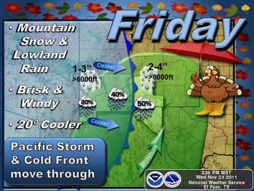
New Mexico Friday.

Southern New Mexico Thanksgiving.

Southern New Mexico Friday.
West Texas Thanksgiving.

West Texas Friday & Saturday.

Rainfall Totals Thanksgiving Into Friday.

Everything still appears on track for our anticipated rain event Thanksgiving night into Friday. Our chances for rain have been boosted up to the 20% to 30% range for tomorrow night. Our chances for rain on Friday have gone up to around 50% to 60%. A few scattered thunderstorms will also be mixed in with this event. Our high temps tomorrow afternoon are still expected to be in the mid 70's across southeastern New Mexico.
Snow levels will be high with this storm due to the tropical nature of the moisture influx associated with the remnant moisture from Hurricane Kenneth. Snow levels should be above 9,000' during the day tomorrow. They will lower with time on Friday down to around 7,000' by the afternoon. Cloudcroft may pick up 2"-4" of the white stuff out this storm. I still think that Ski Apache may do fairly well since its base is at 9,600' and the top of the runs are at 11,400'.
The Truth Is Stranger Than Fiction!


Comments
Post a Comment
Your comments, questions, and feedback on this post/web page are welcome.