

Another Warm & Windy Day.


Unseasonably Warm Overnight.
Our low temperatures were unusually mild across the local area this morning. Downslopping southwesterly winds overnight, and a deck of mid and high level clouds, that continues to stream in from the southwest were responsible for this. A list of some of the warmer readings are noted below.
Carlsbad Airport ASOS 64
Bat Draw Raws - Carlsbad Caverns 61
2.1 NNW Downtown Carlsbad 60
McKittrick Canyon Raws 57
10 Miles ESE Hagerman 56
Paduca Raws 56
Artesia Airport 55
Pinery Raws 55
Guadalupe Pass ASOS 53
2 SW Tatum 53
NW Hobbs - KM5BS 53
Queen Raws 51
Hobbs Airport 50
Dunken Raws 50
Roswell Airport 49
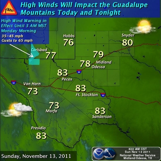
Today will be another unseasonably warm and windy one. Our high temps are forecast to range from 73 in Roswell, 75 in Artesia, to 77 in Carlsbad and Hobbs. Southwesterly-westerly winds will kick up to sustained speeds at around 20-30 mph with gusts this afternoon to near 40 mph.
A High Wind Warning continues in effect for the Guadalupe Mountains until 3 AM tomorrow morning for southwesterly-west winds sustained at around 35-45 mph with gusts to near 65 mph.
Mid and high level clouds will to stream northeastward across the area today into tomorrow as the cutoff upper-level low to our southwest approaches. This upper level storm is forecast to move just to our south by tomorrow night. A few light rain showers and perhaps an isolated thunderstorm or two will be possible over the area tomorrow.
A few high mountain snow showers may also break out over the Sacramento and Capitan mountains today into tomorrow, generally at or above 9,000' today. Snow levels will drop down to between 7,500' and 8,500' late tomorrow afternoon. Overall nothing significant is anticipated from this storm.
High temperatures on Monday and Tuesday are forecast to be in the upper 60's to the mid 70's across SE NM. Cooler air will overspread the area Tuesday night into Thursday. Highs on Wednesday are forecast to be in the mid to upper 50's, with the low to mid 60's expected on Thursday. Friday should see another warm-up commence with highs in the low-mid 70's.
The Truth Is Stranger Than Fiction!


Comments
Post a Comment
Your comments, questions, and feedback on this post/web page are welcome.