


Dense Fog Advisory Until 9 AM MST.
Blog updated at 8:45 AM MST.
Today's Outlook.

This Morning.
for Eddy and Lea Counties in New Mexico, as well as
across parts of West Texas to our east.
Local visibilities may suddenly drop down to less than
one quarter of a mile with little to no advanced
warning this morning. Please drive safely out there.
Rest Of Today.


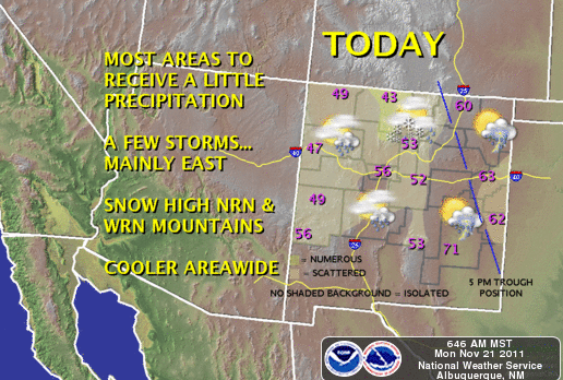

An approaching upper-level storm (depicted above) will sweep
across the state today. This feature combined with low-level moisture
feeding into the area behind a stationary front, will give us a
slight chance for a few scattered thunderstorms today.
Our overall chances are not that great, we only have a 10% - 20%
chance for seeing measurable rainfall. A few of the stronger thunderstorms
may produce small hail, gusty winds, and frequent deadly cloud to ground
lightning strikes. We are looking at highs near 70 today in Eddy and
Chaves Counties, with the low-mid 60's expected in Lea County.
Severe T-Storms Across West Texas Today.


A few severe thunderstorms may break out across parts of
West Texas today. Some of these thunderstorms will be capable
of producing large hail and damaging winds. An isolated tornado
or two cannot be ruled out either.
across parts of the Midland NWS County Warning Area
(Northeastern Permian Basin) by around noon CST today.
Thanksgiving Week Outlook.
Tuesday.

Wednesday.

Thanksgiving.

A mild Thanksgiving is shaping up for southeastern
New Mexico this year. We are still looking at high
temperatures in the 70's. It may turn out to be a
little on the breezy to windy side as another upper-level
storm takes aim on the state. More on this later.
High Temperatures Thanksgiving Day.

The Truth Is Stranger Than Fiction!


Comments
Post a Comment
Your comments, questions, and feedback on this post/web page are welcome.