Howling Winds - Blowing Dust - Snow Tuesday. A Freeze For Many Wednesday Morning.
Valid At Noon MDT Tuesday.
NWS Watches & Warnings In Effect.
As Of 5:30 PM MDT Monday, April 3, 2017.
Late this afternoon a cold upper level storm was dropping south out of the Northern and Central Rockies. By sunrise Tuesday morning it is forecast to be located over the Four Corners Region and by noontime it will be over Northeastern New Mexico and the Texas Panhandle. You know the drill whenever these upper level storms take a track to our north (Southern/Southeastern New Mexico and West Texas) we get side swiped with the wind. And howl it will!
High Wind Warnings and Wind Advisories are now in effect for most of New Mexico on Tuesday. The same applies to West Texas also. Locally High Wind Warnings are in effect for Chaves, Culberson, Eddy, Lea, Lincoln, and Otero Counties. Southwesterly to westerly winds are forecast to increase to sustained speeds of 25-45 mph with gusts up to 50-65 mph across the lower valleys and plains. In the Guadalupe Mountains westerly winds are forecast to become sustained at 40-60 mph with gusts near 80 mph. Across the Sacramento Mountains westerly winds are forecast to gust up to 50-60 mph.
Widespread blowing dust will likely also develop across the area Tuesday reducing the visibility down to 1-3 miles or lower at times. Dust prone locations near open, exposed, or freshly plowed farmlands, fields, lots, and construction sites will experience sudden drops in the visibility down to zero with little to no advanced warning. Brownout conditions will develop over and near these areas on some of our local highways in the stronger wind gusts. Remember the area has a history of multiple vehicle accidents and pileups during our infamous dust storms like the one anticipated on Tuesday. Tragically this sometimes leads to loss of life and injury so please exercise extreme caution on our local roadways Tuesday into Tuesday evening!
Critically Dangerous Fire Weather Conditions are also forecast for the area. Any wildland, rangeland, grass, or forest fires that develops will have the ability to rapidly spread and grow and will prove to be difficult to control or put out in the high winds. Please refrain from any type of outdoor activity that involves the use of sparks or flame especially Tuesday afternoon.
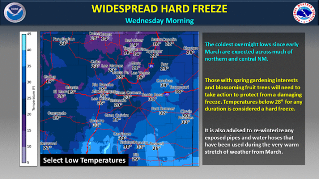
A Freeze Will Be Possible Wednesday Morning.
(Wednesday Morning).
Yea I'm thinking that come Wednesday morning as our skies clear, the dust settles, and a colder air mass moves in behind the departing upper level storm and cold front, some, if not many of us will see a freeze! Sorry about that but protect your pets and plants Tuesday night into Wednesday morning.
More Snow For Western & Northern New Mexico.
The Truth Is Stranger Than Fiction!


Comments
Post a Comment
Your comments, questions, and feedback on this post/web page are welcome.